This year marks the 80th anniversary of the end of a terrible war that affected the entire world.
Brave men and women tried to withstand the horrors in their respective countries by joining the resistance and helping those most at risk to suffer from their oppressors, even at the danger of losing their own lives.
In Malaya, the Japanese occupation was a time of extreme hardship for the people.
Arrests and torture were happening daily, and people lived in fear of the unpredictable actions of the Japanese army, particularly the Kempeitai, under whose terror Sybil Kathigasu suffered physical and mental torture.
Sybil Kathigasu was born Sybil Medan Daly in Medan, Sumatra, on September 3rd,1899. Her father, Joseph Daly, was an Irish-Eurasian planter, and her mother, Beatrice Matilda Martin, was a French-Eurasian midwife.
Sybil Kathigesu (Image from Sybil’s book titled No Dram of Mercy)
Sybil trained as both a midwife and nurse, and her fluency in Cantonese proved invaluable in the medical practice that she and her husband established together.
Sybil’s husband, Dr Arumugam Pillay, was a second-generation Malayan Tamil. To be able to get married in church, Dr Pillay converted and was christened Abdon Clement Kathigasu. They married in Kuala Lumpur on January 7th, 1919, in St John’s Church on Bukit Nanas.
After their first child died only 19 hours after his birth, the couple adopted William, an infant at the time. They later had two daughters of their own, Olga, who was born in 1921, and Dawn in 1936. The family then moved to Ipoh along with Sybil’s mother, where they established their own private practice.
When the Japanese forces, who had advanced from the North, reached Ipoh and started bombing, Sybil decided to move with her children and mother to Papan, a small mining town near Ipoh, while her husband stayed in Ipoh to continue to work in his practice.
Life became harder day by day, and many people in Papan needed Sybil’s help but were quite destitute. Sybil therefore decided to treat those who could not afford much free of charge.
All this while the people of Malaya were quite cut off from any news, as they were not allowed to own any radios or any type of communication with the outside world. Despite this, Sybil managed to get her hands on a shortwave radio to listen to news from the BBC daily. Only her family and a close friend knew about the radio, which she eventually replaced with another two sets. She nicknamed these shortwave radios ‘Josephine’.
They would listen to the radio every evening, after which it would be taken apart and hidden away in a secret compartment under the floorboards to be assembled again the next day. Her family warned her if the Japanese found out about the radios, it would be disastrous.
But she insisted on the need for this sole connection to the world. Her strong faith in God and her belief that the British would soon return to Malaya convinced her to take these risks. Unfortunately, the existence of these radios contributed to Sybil’s arrest.
The Kempeitai immediately arrested anyone who was suspected of committing any crime against the laws they had imposed. Suspects were subjected to various methods of interrogation. Many prisoners endured severe beatings and water torture, leaving them in excruciating pain and barely clinging to life.
Sybil was always very careful not to disclose any of her actions to anyone who was not necessarily involved. She did not want to put them in a situation where they would be forced to give away information under torture.
The area around the town of Papan was where one of the local headquarters for MPAJA (Malayan People’s Anti-Japanese Army) detachments operating in Perak was located.
Despite the dangers, Sybil and her family became increasingly involved in the resistance against the Japanese occupation.
These guerrillas had to hide in the jungle and often needed medical assistance, which was when Sybil was approached to treat them. The sick and wounded guerrillas were brought in through the back entrance of her dispensary, often under the cover of night to avoid detection.
This was extremely dangerous for her and her family, but she strongly believed that it was her duty to help them. The guerrillas trusted her, and she became very close to them, passing on messages and medication.
All this while Sybil was aware of the risk she was taking and was prepared to be captured and put to death by the Kampetei. Her only fear was that anything might happen to her family, and she prayed for their safety daily. Her unwavering faith kept her strong and firm in voicing her opinions and continuing her secret work against the Japanese.
When Sybil was eventually detained by the Japanese police, it was the beginning of two long years of physical and mental torture, but she never gave away any information. Even when her husband and son were arrested, she remained unresponsive to any questioning under torture and kept praying for strength.
Only when Sybil’s youngest daughter Dawn was captured and taken to her in prison did she nearly lose her resolve. The Kempeitai strung the little girl from a tree with a fire burning below while Sybil was forced to watch. The child begged her mother not to give in. After Sybil’s desperate pleading, some Japanese soldiers took pity, cut the rope and freed the child.
Sybil was then sent to Batu Gajah prison, which provided slightly better conditions than the Ipoh Kempeitai facility. At this time, she was already suffering from an injured spine and a broken jaw caused by the boot of a Kempeitai soldier. Sybil eventually lost her ability to walk.
When Sybil, her husband, and son faced trial, she was prepared for the possibility of receiving the death penalty. She was, however, given a life sentence, while her husband was sentenced to 15 years in prison and her son to just 3 years.
On August 15th, 1945, the Japanese capitulated, and the British were back in Malaya. British officers from the military intelligence became aware of Sybil’s experience and offered their help. She asked for her husband and son to be released from Taiping Gaol and for medical treatment for herself.
Sybil was then flown to Britain, where she was treated at the government’s expense. During this time, she began to write her memoirs, “No Dram of Mercy”.
On November 7th, 1947, Sybil Kathigasu was awarded the George Medal by King George VI
at Buckingham Palace for her bravery during the Japanese occupation. She is the only Malayan woman who received this award.
While doctors in Britain treated her for two years, she was eventually able to walk again.
Before she could make a full recovery, septicaemia resulting from her fractured jaw, led to her death in June 1948. She was 49 years old. Sybil was initially buried in Lanark, Scotland. In 1949 her body was returned to Ipoh where she was laid to rest at the cemetery of St. Michael’s Church.
There is very little firsthand knowledge of women’s lives during the Japanese occupation. Sybil Kathigasu’s memoirs are therefore an important source of information. Her remarkable story of strength and courage should not be forgotten.
Sybil Kathigasu died of the injuries inflicted on her by the Japanese Kempeitai. They broke her body, but they could not break her mind.
The House of Sybil Kathigasu in Papan, which housed her clinic, has been turned into a museum and can be visited upon request. Sybil Kathigasu’s story was adapted into a TV drama titled ‘The Price of Peace’ as well as a 10-part miniseries called ‘Apa Dosaku’ starring Sybil’s grandniece Elaine Daly.
Bibliography
No Dram of Mercy, Sybil Kathigasu G.M.
Wong Soak Koon, Trauma and Narrating in Sybil Kathigasu’s No Dram of Mercy
Dr. Saw Chaw Yeh is a Malaysian archaeologist specializing in prehistoric rock art and cultural heritage. She is the author of The Rock Art of Kinta Valley, a comprehensive examination of one of Malaysia’s most significant prehistoric art regions.
Rock art offers a profound glimpse into the lives, beliefs, and artistic ingenuity of ancient communities. According to Dr. Saw, the long-held belief that artistic expression originated in the West has been challenged by discoveries in Southeast Asia, particularly in Indonesia. Caves in Sulawesi and Borneo have revealed animal paintings and hand stencils dating back at least 40,000 years. These findings demonstrate that artistic expression flourished independently in multiple regions, contesting the Eurocentric narrative that art originated in Europe. This shift in perspective underscores Southeast Asia’s vital role in the history of human creativity, further evidenced by the abundance of prehistoric art found in Malaysia.
The Kinta Valley, located in central Perak between the Titiwangsa and Kledang Ranges, is rich in alluvial tin deposits and archaeological treasures. Excavations in its caves and rock shelters have uncovered human remains, stone tools, and pottery shards, indicating human activity spanning at least 10,000 years. Over time, these sites have served diverse purposes for various groups, including the Orang Asli, villagers, traders, and soldiers. Today, some caves have been repurposed as temples, while others face threats from quarrying activities.
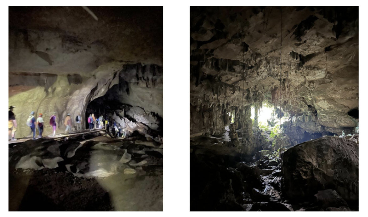
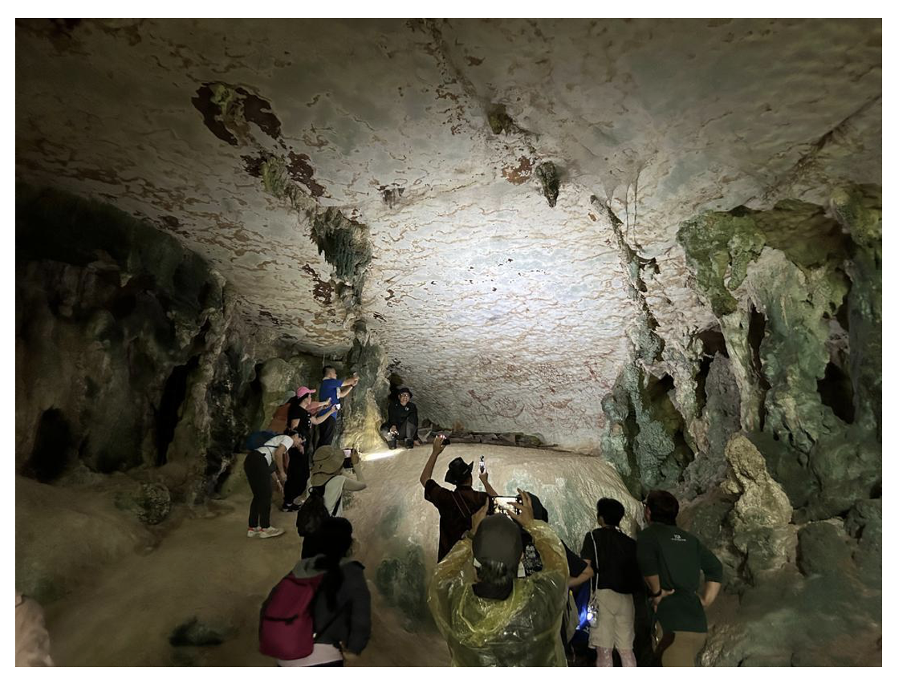
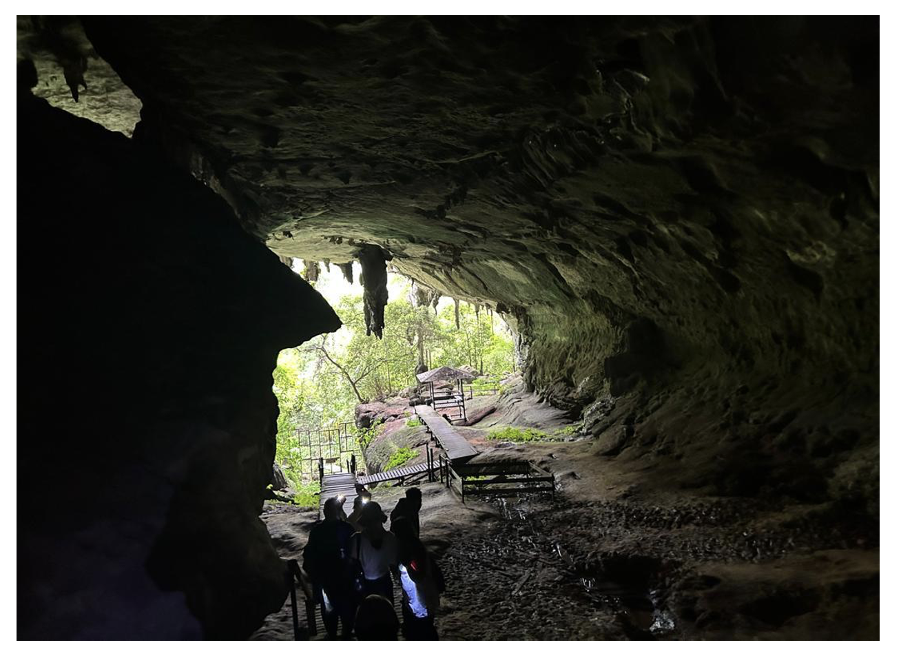
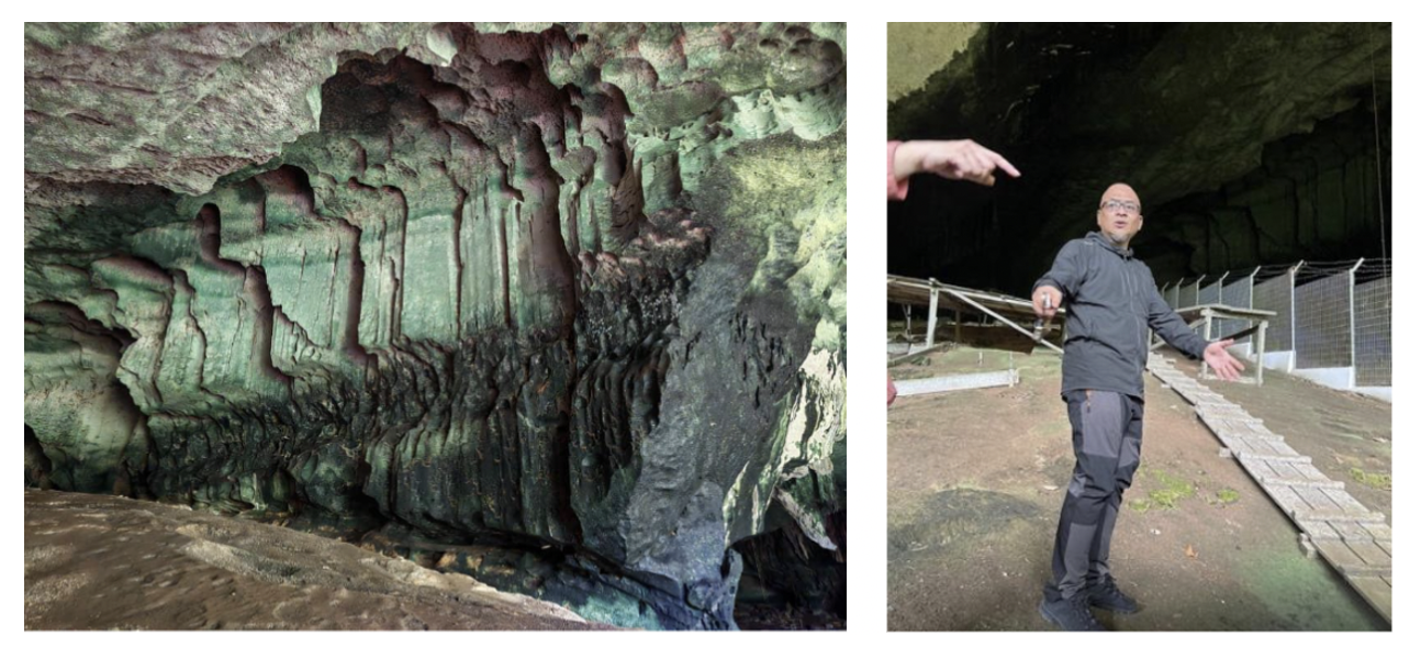
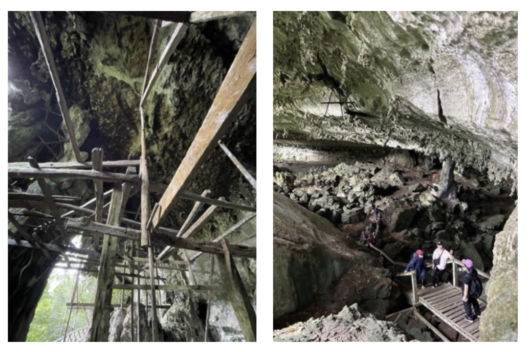
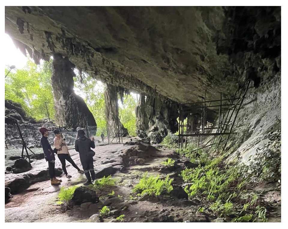
Gua Tambun, a limestone rock shelter perched on a cliff in the Kinta Valley near Ipoh, is among Southeast Asia’s most extraordinary prehistoric rock art sites. It features over 600 paintings, providing a window into the lives and artistic expressions of ancient communities.
The vibrant reddish-orange hues of the paintings, derived from hematite, a natural iron oxide, stand out against the limestone surface. Ancient artisans ground hematite into powder and mixed it with water or organic binders to create durable pigments. The protective overhang of the cliff, combined with the enduring quality of these pigments, has preserved the artwork for millennia. The techniques employed reflect remarkable ingenuity, with fine lines and intricate details suggesting the use of brushes made from plant fibers or animal hair. Broader strokes may have been applied by hand or with pads. The sheer scale and positioning of the paintings, some located at significant heights, imply the use of scaffolding or ladders, indicating a deliberate effort and considerable skill in their creation.
Estimated to date back to the Neolithic period, the Gua Tambun rock art reflects a profound connection to nature and spirituality. The depictions include animals such as deer, tapirs, and fish, often portrayed in dynamic poses suggesting vitality. Human figures, typically shown in ritualistic postures, hint at communal activities or spiritual beliefs. Hand stencils, created by spraying pigment around a hand placed on the rock surface, add a personal dimension, symbolizing identity, community, or spiritual protection. The rare depictions of elephants stand out for their potential symbolic significance. In Southeast Asian traditions, elephants are often associated with power, wisdom, and memory, suggesting these images held special ceremonial or narrative importance.
Other Malaysian sites studied by Dr. Saw further reveal the diversity and complexity of prehistoric rock art. For example, Lumuyu Rock in Sabah, a sandstone outcrop nestled within dense rainforest, features intricate geometric patterns and stylized anthropomorphic figures. These abstract designs, characterized by interlocking lines and symmetrical forms, may carry ritualistic or cosmological meanings. For the local Dusun community and other indigenous groups, Lumuyu Rock remains culturally significant. Beyond its archaeological importance, it symbolizes ancestral heritage, often embedded in oral traditions that preserve community identity and history.
The Niah Caves in Sarawak contain rock art predominantly painted in red hematite, depicting anthropomorphic figures, boats, and abstract motifs. These images resonate with artefacts found within the caves, including boat-shaped coffins and canoe burials, underscoring the cultural and symbolic importance of boats as tools for travel, trade, and spiritual journeys.
Photos of cave art at NIAH CAVES, by courtesy of KAREN LOH
Photo of boat-shaped coffins and cave art at GUA KAIN HITAM, NIAH by courtesy of YUN TENG
The Pengkalan Kempas megaliths in Negeri Sembilan add another dimension to Malaysia’s prehistoric art. These standing stones, adorned with enigmatic carvings, likely served as burial markers or ceremonial artefacts. Their arrangement in clusters suggests a communal purpose, reinforcing their role as focal points of memory and identity. The three-dimensional nature of these carvings offers a contrast to the predominantly two-dimensional imagery of rock art, showcasing the diversity of artistic expression in prehistoric Malaysia.
The choice of specific locations for rock art is deeply rooted in phenomenology, a concept that explores human sensory experiences and interactions with the art, its location and the surrounding landscape. Many sites are near water sources, elevated vantage points, or within naturally sheltered areas, suggesting that their selection was purposeful and symbolic. The acoustics, light, and accessibility of these locations likely enhanced their ceremonial or communal significance. The positioning of Gua Tambun, overlooking the Kinta Valley, imbues it with prominence, likely making it a focal point for community gatherings.
Dating Malaysian rock art presents challenges, particularly in the humid, tropical environment, where organic pigments rarely survive, and weathering accelerates rock surface degradation. Direct dating methods, like radiocarbon analysis, are often impractical, leaving researchers to rely on relative dating techniques. These include stylistic comparisons with other Southeast Asian sites and the analysis of associated artefacts, such as tools or pottery. While current estimates suggest that the rock art at Gua Tambun dates back between 2,500 and 5,000 years, these remain approximations, highlighting the need for advanced, non-invasive dating methods tailored to tropical conditions.
Interpreting prehistoric rock art remains inherently complex. Abstract or ambiguous motifs defy straightforward identification. For instance, some animal depictions lack anatomical precision, prompting debates about whether they represent specific species, imagined creatures, or abstract symbols.
The ambiguity surrounding such depictions underscores a broader challenge in rock art interpretation. Dr. Saw suggests that the artistic choices of prehistoric communities may not have aimed at creating literal representations of their world. Instead, the motifs may have served symbolic, ritualistic, or narrative purposes, conveying meanings that are now largely inaccessible to modern observers.
Dr. Saw’s research identifies parallels between the motifs found in rock art and Orang Asli material culture, hinting at cultural continuity or shared symbolism. However, even these connections are difficult to substantiate fully. According to her, the only direct ethnographic evidence of rock art creators comes from the Lenggong Valley, Perak, where the Lanoh Negrito Orang Asli were historically associated with certain rock art. Dr. Saw deduced that earlier rock art depicting wild animals, large human figures, and geometric shapes aligns with the hunter-gatherer traditions found throughout Southeast Asia. However, determining the creators and meanings of rock art from later periods remains an elusive task .
The Kinta Valley, with its rich history of human occupation, illustrates this complexity. While traditionally inhabited by the Temiar and Semai Orang Asli, direct links between their material culture and the valley’s rock art remain unproven. Unfortunately, modern Orang Asli communities are generally unaware of the origins or meanings of these ancient artworks, reflecting the gradual loss of cultural connections over time.
In addition to these prehistoric examples, some Malaysian rock art sites feature imagery from more recent periods. These include depictions of flags, human figures holding weapons, ships with sails, and individuals with hands on their hips. Such motifs reflect the dynamic and adaptive nature of rock art traditions, capturing moments of cultural contact, conflict, and transformation. Flags may symbolize colonial or national identity, while weapon-bearing figures evoke themes of resistance or dominance. Ships with sails highlight the region’s maritime connections, emphasizing trade, exploration, or migration. The assertive postures of figures with hands on their hips suggest changing social hierarchies or power dynamics.
Dr. Saw emphasizes the urgent need to preserve rock art in the face of environmental and human threats. Malaysia’s tropical climate, with its high humidity and heavy rainfall, accelerates pigment and rock surface degradation. Urban development, quarrying, unregulated tourism, and vandalism further jeopardize these fragile sites.
Photos of GUA BADAK, LENGGONG VALLEY – by courtesy of YEE CHUN WAH
Malaysia’s National Heritage Act provides a legal framework for protecting cultural sites, but enforcement remains inconsistent. Designating rock art sites as protected heritage zones can help shield them from development and exploitation. Enhanced surveillance, stricter penalties for vandalism, and public awareness campaigns can deter damage and promote respect for these cultural treasures.
Digital technologies, including high-resolution imaging, photogrammetry, and 3D scanning, offer invaluable tools for conservation. These methods create detailed records, enabling researchers to monitor changes, explore restoration options, and make rock art accessible through virtual archives.
Effective site management can mitigate environmental damage. Protective shelters, such as canopies or rain-diversion systems, can shield rock art from direct exposure to the elements. Controlling vegetation and water runoff around sites helps minimize erosion and biological growth. Additionally, barriers and designated viewing areas can prevent direct human contact with the artwork.
Indigenous communities, particularly the Orang Asli, are key to effective preservation. Their involvement in monitoring programs, workshops, and educational initiatives fosters a sense of ownership and pride, ensuring sustainable heritage management.
Tourism can be both a threat and an opportunity for rock art preservation. Sustainable tourism models prioritize heritage conservation while offering meaningful engagement for visitors. Visitor centers with digital replicas, guided tours, and interpretive signage provide alternative ways to experience rock art without compromising its physical integrity. Revenue from such initiatives can benefit local communities and fund conservation efforts.
Interdisciplinary collaborations between archaeologists, conservationists, and cultural organizations are vital. Innovative techniques, such as non-invasive graffiti removal, offer promising solutions. International partnerships can bring resources and expertise to address unique challenges in preserving rock art in tropical environments. Although Malaysia’s rock art heritage is in a fragile state, the advent of rapidly advancing technology and wider community involvement offers hope for their protection.
On Saturday 21 December 2024, 30 Museum Volunteers were treated to an educational guided tour of the Malay World Ethnology Museum (MEDM), situated above the Orang Asli Craft Museum and within the vicinity of the National Museum. This museum was officially opened to the public in March 2002 and fun fact, it occupies the first floor of a former Japanese Restaurant, Fima Rantei.
The idea for MEDM was mooted by the first Director General of Museums Malaysia, the late Dato’ Shahrum Yub, following a resolution at the 1989 Malay Civilisation Convention. The architecture of this building is similar to the National Museum. The museum provides visitors with a deeper understanding of Malay arts and culture.
Museum Scope
While the scope of the Malay world encompasses the Nusantara or Malay Archipelago, the MEDM focuses on Malay arts and culture in Malaysia. It:
builds upon and expands the content in Gallery B of the National Museum, offering a detailed exploration of the Malay world artefacts and unique traditions by state.
features and interprets the crafts and traditions depicted on the National Museum’s external West Mural on Malayan Crafts and Craftsmen.
reflects the evolution of the belief systems and practices in the Malay world, transitioning from animism to Hindu-Buddhist influences and finally to Islam, as seen in the essence of the exhibits, its iconography and representations. Islamic elements became the most dominant in shaping the final metamorphosis of Malay thought and culture.
Many Malay customs and traditions have stood the test of time, serving as a source of inspiration for contemporary practices, whether in the original, modernized or evolving form, while preserving their core essence.
Roots of Malaysian Culture
Various governments or Malay Sultanates once occupied the coastal areas of Peninsula Malaysia and to date, there exists nine Malaysian states with a monarchy in place (Perlis, Kedah, Perak, Selangor, Negeri Sembilan, Johor, Pahang, Terengganu and Kelantan).
The Malay people in Malaysia comprise the Kelantan Malays, Kedah Malays, Perak Malays, Sarawak Malays, Kedayan, Jakun and Temuan, as well as other groups originating from other islands in the Archipelago such as the Javanese, Minang, Banjar, Rawa, Bugis, Bawean, Bangkahulu, Kampar and Achenese.
Malaysia is a successor of the Malayo-Polynesian civilisation, and its culture encompasses both physical and spiritual aspects, including tangible creations like buildings, clothing and weapons; and intangible elements like language, literary works and traditions.
Our visit began with a warm welcome from Puan Wan Noazimah Wan Kamal, Director of the MEDM. We were then guided through the museum’s exhibits by Puan Nik Maziela Idura, the Assistant Curator.
Group picture of MVs with the Director, Assistant Curator and MEDM staff
A. The Heart of Malay Culture: A Visual Exploration via Dioramas
There are six dioramas which showcase the importance of traditional crafts and deep-rooted values of family and community.
Diorama 1: Weaving and Traditional Kampung Life
The first diorama takes us to a serene Malay kampung or village, which can be seen in all parts of Malaysia particularly the rural areas. An elderly lady sits on the veranda, skilfully weaving a tikar (mat) from mengkuang leaves, used for sleeping, dining and social gatherings.
The traditional Malay house is raised above the ground to protect from floods especially for the eastern coastal areas. The space beneath the house is used to store boats; vital for transportation in riverside villages.
The kampung house features three main areas:
The Serambi (Verandah or Front Hall) for welcoming guests and family gatherings
The Rumah Ibu (Mother’s Room), the heart of the home
The Dapur (Kitchen) at the rear
This diorama illustrates the architectural heritage and practical design of Malay kampung houses, which exist in harmony with its surroundings.
Diorama 2: The Art of Wau Making
The second diorama exhibits the intricate art of wau (kite) making. A skilled craftsman is seen constructing a wau using strips of bamboo, cut with a carving knife. Cut coloured paper is glued on, with designs that reflect the aesthetics of Malay art.
An important aspect of wau making is in ensuring the frame is symmetrically balanced so the wau will fly gracefully through the sky. With a distinctive head, body and tail, it symbolises a bird in flight and represents freedom and aspirations.
Each state boasts its own unique wau designs, such as the “Wau Kapal” of Selangor and the “Wau Bulan” of Kelantan. For frequent flyers, this Wau Bulan icon would be a familiar feature. Our local carrier, Malaysian Airlines’ iconic logo draws inspiration from the traditional Wau Bulan.
The diorama also features a traditional Singgora roof, originating from Thailand, featuring the cultural exchange that has enriched Malay architecture. These clay tiles are fired and placed on the rooftop to give a natural cooling effect. We see a harmonious integration of traditional building techniques with the natural environment.
Diorama 3: The Magic of Wayang Kulit
The third diorama brings us to the world of Wayang Kulit, a traditional shadow puppet theatre and entertainment. An ensemble of gamelan drums and other musical instruments fill the air as the Tok Dalang, the master puppeteer, weaves a captivating narrative.
Based on ancient Hindu epics of Ramayana and Mahabharata, the stories unfold as the carved leather puppets, mounted on banana trunks, are manipulated against a brightly lit white screen, using a kerosene lamp.
The Tok Dalang is a skilful vocal master who employs at least ten distinct voice tones to bring the diverse characters to life – heroes, villains, kings and even a jester, who adds a touch of comic relief. And this is where the magic begins, with the Tok Dalang bringing each character alive!
The diorama displays three styles of Wayang Kulit:
Kelantanese: Characterised by puppets and manipulated with a single central stick or arm, often depicting the character riding a dragon-like vehicle. The performance begins with a symbolic gesture of waving the Pohon Beringin or Tree of Life, representing a tribute to mother nature, to start the theatrical journey.
Javanese: Influenced by Javanese traditions, these puppets are manipulated with both hands. The character’s eyes provide clues about their nature – good or evil. They are commonly found in Johor, a state in southern Malaysia, located near the island of Java, separated by the Straits of Malacca.
Gedek Talung: Found predominantly in northern states like Perlis and Kedah, this style reflects Siamese influences, employing a Siamese dialect and featuring puppet designs influenced by Thai aesthetics.
While traditional stories remain central, adaptations have emerged, incorporating elements of popular and current culture, such as Star Wars, Musang King and even using contemporary languages like Japanese and Korean, to connect with current audiences.
Diorama 4: A Celebration of Love: A Malay Wedding
The fourth diorama captures the vibrant and colourful atmosphere of a traditional Malay wedding ceremony. The bride and groom, adorned in exquisite songket attire, receive blessings as rose water and potpourri are gently sprinkled upon them.
The exchange of hantaran, or wedding gifts, is a momentous ritual, with the bride typically presenting trays of gifts, reciprocated by the groom at a lesser number, symbolising the greater contribution of the bride to the marriage. The offering of bunga telang flowers with hard-boiled eggs to guests, signifies fertility and good wishes for the newlyweds.
This diorama portrays the significance of customs, tradition and community in celebrating the union of two souls. The hantaran custom continues to be observed, even in modern day weddings today.
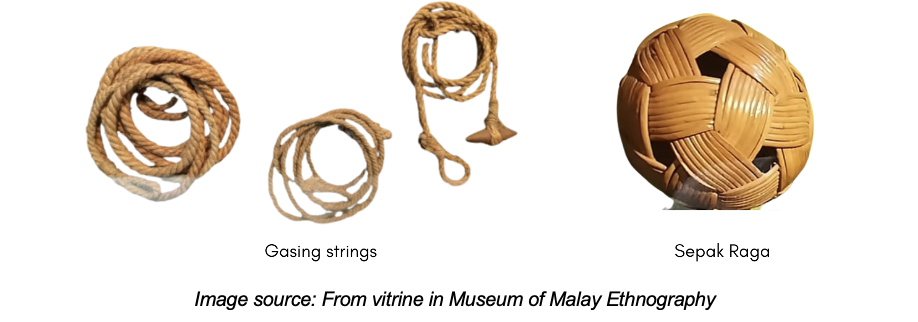
Dioramas 5 and 6: The Game of Congkak and Spinning Gasing
The fifth diorama features the traditional game of congkak. A young woman sits gracefully, her fingers moving as she plays the game on a carved wooden board. Congkak involves two players competing to collect the most seeds or marbles in their respective “homes”. In older times, holes were dug in the ground to create a natural congkak playing board.
The sixth diorama shows a man engaging in the traditional game of spinning the gasing or top spinning. Tops are also made from wood.
These dioramas depict the social and recreational aspects of Malay culture, showing how games like congkak and gasing, have not only been a source of entertainment but social interaction and intellectual stimulation. A pastime that has enriched the lives of communities for generations, it also emphasises the artistry and craftsmanship involved in developing these instruments.
B. The Vitrines: A Window into Malay Culture
Next, we explore the vitrines that showcase key themes of the Malay world.
1. Sailing and Seafaring
The different types of sea vessels
This vitrine explores the profound influence of the sea on Malay culture, evident in the concept of Motherland or Tanah Air – a connection to both land and sea. Skilled navigators, like Panglima Awang, navigated voyages by relying on the water, wind and stars, demonstrating remarkable seafaring skills without relying on compasses.
Malay boatbuilding was a sophisticated art. Vessels ranged from perahu (small fishing boats) to larger boats for deep-sea fishing and jongs capable of carrying hundreds of tons which played a vital role in regional trade. These vessels were meticulously crafted using wooden pegging, showcasing impressive engineering skill. Some of the key ports along their seafaring routes included Aceh, Padang, Palembang and Banten.
The vitrines reveal fascinating details. A wooden box, likely made from cengal or alternatively jackfruit wood, holds hooks, gadgets, knives and even a first aid kit. Carvings of rice grains and flowers adorn the box. Next to it, is a utility box in rectangular shape which also functions as a seat and a food box which is round in shape, possibly designed for the royalty, as it features intricate decorations.
Motifs adorning the vessels
Cultural influences, from early indigenous beliefs to Islamic symbolism, are evident in the ornate carvings and mythical motifs adorning the vessels. We see the heads of boats ornamented with bangau (stork), okok and also makaras (mythical sea creatures). Historical accounts from China and the Netherlands attest to the scale and sophistication of Malay maritime activities.
2. The Sound of Music: Musical Instruments
Musical instruments explained
Musical instruments in the Malay culture were significantly influenced by Arab merchants who arrived in Melaka. These instruments were assimilated and found their place in various ceremonies, including weddings, the coronations of Sultans and Kings and traditional performances.
The gendangis a drum made from animal skin, played with hands or sticks. It comes in various sizes and types, including single-sided and double-sided drums. Gendang are commonly used in ceremonies and cultural events.
The kompang is a drum made from cow skin and was traditionally used to gather local people’s attention to their wares during trade activities.
The rebab is a bowed string instrument, originally from the Middle East but became prominent in Malay music. It is worth noting that the rebab tunes were likely influenced by interactions among traders at various stopovers along a combination of maritime and overland trade routes.
The gambus is a plucked lute from the Middle East, popular in Malaysia. It has 3-12 strings and a distinctive half-pear shape. It’s often used for entertainment, accompanying zapin dances and ghazal singing.
Gong comprises large and small gongs, the integral components of gamelan and Wayang Kulit performances.
The angklung is a traditional Indonesian bamboo instrument that produces sound when pulled and shaken at the bottom and often played in groups, accompanying dances like Kuda Kepang and Barongan.
The serunai or flute is a woodwind instrument with Sumatran roots from Minang immigrants, often played during weddings, pencak silat martial arts and wayang kulit shows.
3. Malay Accessories and Ornaments
Malay Accessories
This section showcases selected elements of traditional Malay accessories and ornaments:
Pending cutam: These are traditional buckles used in Malay attire, with the silver pending featuring ornate floral motifs worn by women, often indicating high social standing. The nielloware pending is used as a buckle for men’s silver belts and are crafted with ornate floral designs and the use of gold.
Artisan Jewellery Brooch: The three-piece brooch holds symbolic or cultural significance, perhaps related to status or lineage.
Caping: A silver protective covering functioning like a modesty cover for genitals worn by young children under the age of three, common among wealthy Malay families on the East Coast. These were associated to fertility beliefs or protection, reflecting religious and cultural practices.
Pillow-End Plates: These decorative items, stitched with silver and gold-plated thread, further highlight the emphasis on aesthetics and wealth within the upper classes.
These accessories, along with their intricate designs, reflect the social stratification of the time, where access to fine clothing and adornments were often reserved for the wealthy.
4. Traditional Costumes
MVs adorning their creation after a demonstration and successful hands-on session on folding a Dendam Tak Sudah tengkolok/destar
Malay attire reflects trade and cultural exchange, evident in the use of fabrics like Chinese Silk and Indian Petola. Songket, a prestigious woven fabric with intricate gold or silver threads, is particularly prominent in Kelantan and Terengganu.
Various traditional clothing styles, including Kebaya Labuh, Cik Siti Wan Kembang, Baju Kurung Teluk Belanga and Cekak Musang, each have unique characteristics and regional associations. Overall, Malay attire showcases the enduring influence of cultural traditions and craftsmanship.
5. Weaponry: Malay Arms and Armour
This exhibit showcases the martial traditions of Malay society through a display of weaponry, including cannons, short weapons and long weapons.
Cannons: Originally from Sumatra, these weapons were designed for portability and warfare. Smaller versions were even used as wedding gifts in Brunei.
Short Weapons: The most notable is the Keris, a traditional dagger with a head, body and sheath. It served as a status symbol and weapon
Long Weapons: The exhibit includes the tombak and the lembing, both types of spears used in warfare.
The Palace’s strict monitoring of weapons’ production highlights the importance of controlling weaponry within the royal court to maintain social order.
6. Utensils
Traditional Malay utensils
Traditional Malay utensils, often crafted from metals like silver and brass, are adorned with niello, a technique of inlaying metal. These functional pieces such as moulds for putu, bahulu and kuih kapit or love letters, hold cultural significance and evoke nostalgic childhood memories.
7. Pottery
Pottery is a traditional Malay craft with key production centres in Kelantan, Kuala Kangsar, Pahang and Sarawak. One of the better-known pottery products is the Labu Sayong, used to store cool drinking water. It’s made from processed clay, shaped and fired to increase its durability and water resistance. The design of pottery often reflects its intended function.
8. Brassware
Malay brassware, a testament to skilled artisans, particularly in Terengganu, plays a vital role in Malay culture. From ornate ceremonial pieces used in royal courts such as betel leaf boxes, trays and tiered serving dishes, to functional household items like kettles, pots and decorative lamps, brassware reflects the rich Malay heritage and artistic traditions.
9. Nielloware
Nielloware, a luxurious silverware from southern Thailand, was traditionally used by royalty. Crafted from silver alloy often with gold, it features elaborate designs. It is common especially in Kedah, Kelantan, Perak and Pattani. Nielloware items include bowls, jars and accessories.
10. Silverware
Malay silversmithing, with a history rooted in royal patronage, produced exquisite items for both ceremonial and everyday use. From ornate royal regalia like sceptres and crowns to functional household items such as betel containers, trays, teapots and even decorative items like jewellery and hairpins, these silverwares often feature refined designs, reflecting the wealth and status of their owners.
11. Woodcarving
Malay woodcarving is a significant cultural art form, characterised by delicate designs inspired by nature, religion and philosophy. Skilled artisans utilise techniques such as ukiran timbul (raised carving) and ukiran tebuk tembus (perforated carving) to create stunning works of art.
These carvings adorn palaces, homes and religious structures, often featuring motifs like floral patterns, calligraphy and geometric shapes. Examples include ornate door panels, intricately carved window frames and decorative elements on furniture and household items.
Summary
The Malay World Ethnology Museum offers a captivating journey through the heart of Malay culture, providing valuable insights into the rich heritage, traditions and artistic expressions that define this vibrant civilisation. Through a combination of dioramas, artefacts and informative displays, the museum effectively communicates the legacy of Malay culture.
Visitors are encouraged to visit and immerse themselves in the museum’s diverse exhibits. This allows them to connect with the past, link to the present, and reflect on their own experiences, to gain a deeper understanding and appreciation of Malay values and traditions.
The surrender of British forces to the Imperial Japanese Army on 15 February 1942 was more than a military defeat, it was a shattering of colonial dominance in Southeast Asia. In his compelling talk, Zafrani Amran explores the calculated strategies, critical oversights, and unforeseen events that led to this seismic event.
Japan’s Rise to Power and Expansionist Ambitions From the Meiji Restoration in 1868 to the early 20th century, Japan transformed from a feudal society to a formidable industrial power. This modernisation fuelled its ambitions for regional dominance, culminating in its aggressive expansion across Asia. The slogan “Fukoku Kyohei” (Rich Country, Strong Army) guided the nation’s transformation.
By the late 1930s, Japan faced crippling resource shortages due to international embargoes, particularly on oil and rubber. These pressures drove its decision to secure Southeast Asia’s rich resources, making Malaya a critical target.
Key milestones in Japan’s rise include:
Event
Year
Significance
Meiji Restoration
1868
Japan begins its modernisation process.Formation of the Imperial Japanese Army and Navy
Treaty of Ganghwa
1876
Opening Korea to Japanese influence
First Sino-Japanese War
1894-1895
Japan defeats China, gaining control of Taiwan and Korea.
Anglo Japanese Alliance
1902-1923
Japanese forces provided military support as part of this alliance, a role evident during the Singapore Mutiny of 1915.
Russo-Japanese War
1904-1905
Japan defeats Russia, emerging as a major power in Asia.
Annexation of Korea
1910
Japan formally annexes Korea.
Invasion of Manchuria
1931
Japan seizes control of Manchuria.
Second Sino-Japanese War
1937-1945
Japan invades China. (Marco Polo bridge incident)
Tripartite Pact,
September 27, 1940
a military alliance between Germany, Italy, and Japan, aimed to deter U.S. intervention in World War II
Occupied French Indochina
July 1941
To secure its supply lines and further isolate China.
Capture of Lashio and closure of the Burma Road
April 1942
To further isolate China, Japan closed the Burma Road, a key supply route for Western aid.
Japan’s Road To Conquest Japan’s prolonged war with China drained its resources. To secure vital supplies and cut off Chinese access to foreign aid, Japan occupied French Indochina, a move facilitated by the Vichy French regime (a pro-German regime).
Faced with a crippling U.S. oil embargo, Japan sought alternative resources in Southeast Asia, particularly the oil-rich Dutch East Indies. Despite attempts at negotiation, the Dutch, backed by the U.S., refused to meet Japan’s demands. Recognising the intransigence of the Dutch and the urgency of its resource needs, Japan concluded that military force was the only viable option. To secure these resources and neutralise potential threats, Japan launched a bold military campaign. The attack on Pearl Harbor and the invasion of Malaya were crucial steps in this strategy, by neutralising the U.S. Pacific Fleet and capturing key British military bases, Japan aimed to create a defensive perimeter in the Pacific and secure its resource supply lines.
The desire for natural resources, particularly oil, and the pursuit of a “Greater East Asia Co-Prosperity Sphere” propelled Japan towards a fateful confrontation with the Western powers.
Preparation for War: The Malayan Campaign To prepare for the invasion of Malaya, the Japanese military undertook a series of strategic initiatives:
● Establishing a Research Section: The “Taiwan Army Research Section,” led by Colonel Masataro Tsuji, was established to develop specialised tactics and doctrine for jungle warfare.
● Intensive Training: The Japanese military conducted extensive training exercises in Taiwan and Hainan Island, focusing on beach landings, rapid advances, and combined arms operations in jungle terrain.
● Intelligence Gathering: A network of spies (referred to as a “fifth column), including Major Kunitake, was deployed to gather critical intelligence on Malaya’s terrain, infrastructure, and British defences. ○ Major Kunitake, stationed as an assistant Japanese consul in Singapore, identified over 250 bridges crucial for military operations, enabling the Japanese to pre-plan rapid repair efforts in the event of British sabotage.
● Developing a Comprehensive Guidebook: Colonel Tsuji’s tactical manual, aptly titled “Read This Alone, And The War Can Be Won,” (これだけ読めば戦は勝てる) equipped Japanese troops with jungle warfare expertise.
By meticulously planning and preparing for the invasion, the Japanese were able to exploit the weaknesses in British defences and achieve a swift victory.
Singapore Naval Base The Singapore Naval Base was a monumental engineering feat and a symbol of British naval power in the Far East. Constructed over a period of nearly 15 years, the base was intended to serve as an impregnable fortress, safeguarding British interests in the region.
The decision to establish the base was driven by growing concerns about Japanese expansionism. As Japan emerged as a regional power, the British recognised the need for a strong naval presence in Southeast Asia. The base was strategically located to protect British trade routes and to deter potential aggression from Japan.
The construction of the Singapore Naval Base began in 1923, but progress was interrupted due to political changes in Britain. The Conservative Party, which initially pushed for the construction, was replaced by the Labour Party in 1924, which halted the project due to economic concerns. Work resumed, and after nearly 15 years, the base was officially opened in 1936, featuring state-of-the-art facilities, including the world’s third-largest floating dry dock. The base’s construction was funded in part by local contributions, with the Federated Malay States and the Sultan of Johore (Sultan Ibrahim Ismail) providing significant financial support. In recognition of the Sultan’s generosity, one of the coastal defence batteries was named the Johore Battery. The base was equipped with powerful coastal defences and protected by the Royal Air Force, making it a formidable fortress.
To safeguard the naval base, the British established fixed defences organised into two Fire Commands:
Fire Command:
Changi
Faber
Location:
Protected the routes leading to the naval base at Seletar.
Protected the approaches to Keppel Harbour and the western channel of the Johore Straits.
Armament:
Each Fire Command was equipped with:One 15-inch batteryOne 9.2-inch batterySeveral 6-inch batteries
The Japanese devised a two-pronged strategy to circumvent Singapore’s formidable defences. Instead of a direct frontal assault, they opted for a flanking manoeuvre, attacking from the Malayan Peninsula.
A World Awakened While the attack on Pearl Harbor (December 8, 1941) captured global attention, another battle was unfolding in Malaya. The Battle of Kota Bharu marked the beginning of Japan’s rapid advance, exploiting British vulnerabilities with surgical precision.
On the night of December 4th, the Japanese Imperial Army had set sail from Samah Harbour in Hainan Island, their destination: the Malayan Peninsula. Meanwhile, in Singapore, a sense of security prevailed. The arrival of the powerful Royal Navy battleships, Prince of Wales and Repulse, had bolstered British confidence. These formidable warships were seen as an impenetrable shield against any potential threat.
However, the Japanese had a different plan. On December 6th, Royal Australian Air Force (RAAF) Hudson aircraft spotted the Japanese convoy stealthily manoeuvring south of Cape Cambodia. The British were alerted, but the dense monsoon clouds provided the invading force with a veil of concealment. Operation Matador was considered. This plan involved a preemptive strike into southern Thailand to disrupt Japanese landing plans. However, the British Minister in Bangkok, Joseph Crofty, strongly advised against this course of action, fearing it would provoke a wider conflict. Operation Matador was ultimately cancelled.
The following day, December 7th, the Japanese fleet appeared on the radar screens, 110 miles north of Kota Bharu. The British, caught off guard, scrambled to respond. But the thick, impenetrable fog provided the Japanese with a crucial advantage, allowing them to close in undetected. As the fog lifted, the full scale of the Japanese invasion became apparent. The British, despite their valiant efforts, were ill-prepared to counter the swift and decisive Japanese advance.
The Battle of Kota Bharu A lone soldier, silhouetted stark against the lightning sky, pointed a trembling hand out to sea. There, riding low in the water, a dark armada materialised from the mist. Japanese warships, led by the ominous Awajisan Maru, were disgorging a terrifying wave of soldiers into landing craft.
The deafening roar of Japanese bombers pounded the airfields at Kota Bharu, Machang, and Gong Kedak. Explosions rocked the nearby airfield, the once-proud defenders of Kota Bharu were now a scattering of panicked men, their dreams of a valiant stand shattered by the overwhelming force of the enemy. Meanwhile, the Japanese naval escort, facing heavy losses from RAAF air attacks, considered withdrawing. However, Major General Takumi, determined to secure the beachhead, overruled the decision.
With air superiority lost and the ground defences crumbling, Brigadier Key ordered a retreat to the southern outskirts of Kota Bharu. The Japanese, under the cover of darkness, launched a final assault on the airfield, capturing it by midnight. The Dogra Regiment, though outnumbered and outgunned, fought with courage and determination. Lieutenant Close, led his men in a desperate last stand, but the relentless Japanese onslaught proved too much to bear. The fall of Kota Bharu marked the beginning of a long and painful retreat for the British forces in Malaya, a defeat that would reverberate through the annals of history.
Lone Bomber While the Japanese 5th Division stormed the beaches of southern Thailand, another drama unfolded on the other side of the Malay Peninsula. At the battered Butterworth airfield, a lone figure emerged: Squadron Leader Arthur Stewart King Scarf. A pilot of extraordinary courage, he was the last hope for the beleaguered British forces.
As the Japanese air force rained destruction upon the airfield, Scarf defied the odds. In his battered Bristol Blenheim, he took to the skies, his mission was audacious: to strike at the heart of the Japanese invasion, targeting the enemy airfield at Singgora.
With enemy fighters hot on his tail, Scarf pressed on, his plane a mere speck against the vast expanse of the sky. Undeterred, he unleashed a torrent of bombs, sowing chaos among the Japanese forces. But the cost was high, his plane, riddled with bullet holes, began to falter.
Wounded and weakened, Scarf struggled to regain control. With a final act of defiance, he attempted to land at Alor Setar airfield. However, his injuries proved too severe, he succumbed to his wounds. Squadron Leader Scarf’s bravery earned him the highest military honour, the Victoria Cross.
A Self-Inflicted Wound The morning of December 8th, 1941, dawned with a false sense of security. The mighty HMS Prince of Wales, a symbol of British naval might, sailed out of Singapore Harbor towards the South China Sea, little did they know, their fate was sealed.
Winston Churchill’s public declaration of the Prince of Wales’s mission proved to be a fatal mistake. The British Prime Minister, in a moment of hubris, had inadvertently tipped his hand to the Japanese. Admiral Isoroku Yamamoto, the mastermind behind the attack on Pearl Harbor, seized the opportunity. He dispatched a wave of Mitsubishi G4M bombers to reinforce the already formidable air power in the region. These bombers, specially trained for ship-killing operations, were capable of launching torpedo attacks at extremely low altitudes.
The British mistook an Australian auxiliary plane for a Japanese threat, causing the Prince of Wales to turn back towards Singapore. Meanwhile, a Japanese submarine had detected the ship and dispatched its own bombers to deliver the killing blow. The Japanese attack was swift and decisive. Torpedoes tore through its hull, sending the once-mighty warship to the depths of the ocean. The sinking of the Prince of Wales and its sister ship, the battlecruiser HMS Repulse, marked a turning point in naval warfare, demonstrating the vulnerability of capital ships to air power.
Image source: Encyclopedia of Malaysia: Government and Politics (1940-2006), Page 22
Battle of Jitra Jitra, a sleepy hollow in northern Malaya, was about to become a battleground. As the Japanese juggernaut from the Seiki Detachment advanced southwards, a sense of dread settled over the British defenders.
The British plan was simple: hold the line with two brigades, the 15th Indian Brigade on the right and the 6th Indian Brigade on the left. A makeshift bunker at Changlun Timah, a roadblock hastily constructed, was meant to slow the Japanese advance. Several bridges were to be blown up along the Trunk Road and the main bridge over the Sungei Bata. However, the Japanese, with their characteristic ruthlessness and efficiency, had other plans.
The Japanese, on the other hand, were a well-oiled machine, having repaired damaged bridges, bypassed the British defences and launched a surprise attack on the Changlun Timah outpost. The defenders, caught off guard, were overwhelmed. The Japanese tanks, relentless and unstoppable, tore through the British lines, leaving chaos and destruction in their wake.
Meanwhile, a miscalculation by the British further compounded their woes. Mistaking a friendly force for the enemy, they destroyed a vital bridge at Manggoi River, cutting off vital supply lines. The Japanese, seizing the opportunity, exploited the confusion and pushed deeper into British territory.
British Order of Battle at Jitra, 11th Indian Division (Major General D. M. Murray-Lyon)
28th Indian Brigade (Brigadier W. St. J. Carpendale)
3 Gurkha Battalions
Divisional Reserve
155th Field Regiment
Artillery Support
22nd Mountain Regiment
Artillery Support
80th Anti-Tank Regiment
Artillery Support
As the British retreated, the 28th Brigade was tasked with reinforcing the beleaguered 15th Brigade. The 28th Brigade, led by a determined commander, managed to halt the Japanese advance in several key engagements. However, the overall situation remained grim. The British, outnumbered and outgunned, were struggling to contain the relentless Japanese onslaught. The British retired in disorder towards Gurun, 30 miles along the Trunk Road to the south. The fate of Malaya hung in the balance.
Battle of Kampar After the disastrous defeat at Jitra, the British forces retreated to the Kampar line, a defensive position that offered some natural advantages. Brigadier A.C.M. Paris, temporarily commanding the 11th Indian Division, hoped to hold the line and buy time for reinforcements to arrive. However, the Japanese 5th Division, led by Lieutenant General Matsui Takuro, was relentless. The Japanese launched a series of attacks, but the British defenders, though outnumbered and outgunned, fought with courage and determination.
The Japanese, however, were not to be denied. They launched a flanking manoeuvre, landing troops at Hutan Melintang. This move threatened to cut off the British supply lines and outflank their positions. Faced with this imminent threat, Brigadier Paris was forced to order a withdrawal. The Battle of Kampar, though a valiant effort, marked another significant setback for the British forces in Malaya.
Battle of Kuantan The coastal town of Kuantan became the next battleground, with the 22nd Brigade tasked with defending the vital airfield. The British had fortified the beaches with pillboxes and barbed wire. The Japanese, ever relentless, launched a two-pronged attack on Kuantan. The Takumi Detachment advanced directly towards the town, aiming to capture the vital airfield. Simultaneously, another Japanese force attacked from behind, infiltrating through the rugged terrain of the Jabor Valley.
The fighting was fierce, with both sides suffering heavy casualties. Lieutenant Colonel Cumming, leading the 2/12th Frontier Force Regiment, displayed extraordinary courage in the face of overwhelming odds. Despite being wounded twice, he led his men in a desperate counterattack, buying precious time for the British forces to withdraw. His heroic actions earned him the Victoria Cross.
The fall of Kuantan marked another significant setback for the British. The loss of the airfield deprived the Allied forces of a vital airbase, further weakening their ability to resist the Japanese advance. As the British retreated, the shadow of defeat loomed large over Malaya.
Battle of Slim River The battered British forces, reeling from the defeat at Kampar, retreated to the Slim River line. The dense jungle on either side of the road and railway track offered a semblance of security.
The Japanese, relentless as ever, launched a surprise attack in the early hours of the morning. Tanks rumbled through the jungle, their tracks tearing through the dense undergrowth. The British, caught off guard, were overwhelmed by the sheer force of the Japanese assault. Communication lines were down, and units were isolated, struggling to coordinate their defences. The British, unable to coordinate an effective defence, were forced to retreat.
The Fall of Kuala Lumpur The relentless Japanese advance continued, and soon the heart of Malaya was within their grasp. Kuala Lumpur, the bustling capital city, fell to the invaders on January 11, 1942. The Japanese, utilising bicycles to swiftly maneuver through the dense jungle, outmaneuvered and overwhelmed the British defenders.
Battle of Gemas The final chapter of the Malayan Campaign unfolded in the southernmost state of Johor. The Australian forces, now tasked with defending the beleaguered peninsula, faced a daunting challenge. The Battle of Gemas was a desperate attempt to slow the Japanese advance. Australian troops, under the command of General Bennett, planned an ambush to inflict heavy casualties on the enemy. However, a series of tactical errors and logistical failures undermined the plan. The retreat from Muar, a crucial defensive position, further weakened the British defenses. The surviving troops were forced to withdraw to Parit Sulong, where they faced another brutal battle.
As the Japanese closed in on Johor Bahru, the British were forced to make a difficult decision. To deny the enemy a vital bridgehead, they destroyed the Johor Causeway, severing the land link between Malaya and Singapore. With the fall of Johore, the British were forced to abandon Malaya and retreat to the island fortress of Singapore.
And then a hero comes along… The fall of Singapore was a devastating blow to the British Empire. However, even in the darkest hours, acts of extraordinary bravery emerged. One such act was the heroic last stand of Lieutenant Adnan Saidi and his men at Pasir Panjang.
Adnan, a young Malay officer, led his troops in a desperate defense against the invading Japanese forces. Outnumbered and outgunned, they fought with courage and determination, holding off the enemy for days. The battle at Pasir Panjang became a symbol of resistance and sacrifice, inspiring generations of Malaysians.
Adnan, a true patriot, paid the ultimate price for his bravery. He was captured and executed by the Japanese, but his legacy lives on. He is remembered as a national hero, a symbol of courage and sacrifice.
The Japanese, with a formidable force of approximately 70,000 troops, needed just 68 days to conquer the Malay Peninsula and Singapore—one of the most decisive victories of World War II. Following this swift campaign, northern Borneo succumbed shortly after, with Sarawak and British North Borneo falling under Japanese control by the end of January 1942, facing minimal resistance.
The fall of Malaya was a turning point that reshaped Southeast Asia’s political and military landscape. It exposed the vulnerabilities of colonial powers and the impact of underestimating an adversary. Zafrani Amran’s analysis highlights the complexities of this campaign, reminding us that history’s lessons are as vital today as they were then.
About the speaker Zafrani Amran hails from Kota Bharu, Kelantan, a place rich in history and significant as the site of the Japanese landing during World War II. Growing up, Zafrani often visited the beach, where he saw the pillbox and heard harrowing tales of Indian soldiers, chained inside, forced to fight against the Japanese. His father, who grew up during the Japanese occupation, also shared vivid accounts of life during that time. These stories sparked his curiosity and ignited a lifelong passion for uncovering and preserving stories from the Japanese occupation of Malaya.
A group of Museum Volunteers (MV) gathered bright and early on a Tuesday morning, 19 November 2024, to explore the National Textile Museum’s special exhibit, Telepuk: The Art of Gold Leaf (Pesona Telepuk: Seni Perada Emas). Adding to the buzz of the day, a telepuk-making workshop was in full swing, with our very own MV’s Hani and Farah, rolling up their sleeves and getting hands-on with the craft.
MV group photo, taken by Kulwant Kaur
Puan Salmiah ushered us to Gallery Saindera, where the textile exhibit is being showcased from 28 October to 31 December 2024. It’s divided into five segments, showcasing a whopping 183 collections. Among these, you’ll find 49 stunning examples of telepuk textiles, 130 intricately designed telepuk stamps, and a handful of manuscripts and publications that tie it all together.
In ancient Malay literary texts, telepuk originally referred to a type of lotus, the nymphaea stellata. Over time, the word became closely tied to the textile itself. Some believe it refers to the floral stamps used in the process, while others think it describes the shimmering golden patterns on the fabric, reminiscent of sunlit lotuses glistening on a calm lake. (https://telepuk.com/history/)
The first segment focused on the history of telepuk. This traditional technique involves creating motifs and designs on fabric, especially woven cloth, using a stamping technique with gold leaf. Artisans stamp Arabic gum onto the forearm, followed by the telepuk stamp carved with motifs. The gum acts as an adhesive for the gold leaf, which is then pressed onto the fabric. Kulwant asked why the forearm is used, and Puan Salmiah explained that its temperature is ideal for stamping. If the forearm isn’t used, the thigh is the alternative.
The table below highlights the diverse names and practices of telepuk in Malaysia, Indonesia, and Korea, emphasising its royal connections and the use of gold leaf in textile decoration.
Country
Name
Details
Malaysia
Telepuk / Kain Serasah
Uses 24k gold leaf (often imported from Thailand) and is applied on woven fabrics like limar and satin, but not songket, as the latter already incorporates gold threads, making the combination visually excessive. Note:Gold leaf is imported from Thailand for its superior quality. It is produced in Thailand because it is traditionally used in the royal attire of the King of Thailand.
Indonesia
Perada
Shares similarities with telepuk; the exact application and materials may vary.
Korea
Gyumbak
Reserved for royalty (Joseon Period, 1392~1910), often adorning fine textiles with gold leaf or foil.
Sri Lanka
Use gold water instead of gold leaf
India
Varak
In Rajasthan, particularly in Jaipur, Sanganer, Jodhpur, Sawai Madhopur, and parts of Gujarat, artisans practise a technique called varak, where delicate sheets of gold leaf, known as patra, are adhered to textiles. This is done using a special glue called safeda or saresh, made from powdered resin. A later variation, known as khari, uses gold powder instead of leaf, giving the textiles a slightly different but equally striking effect.
Among the displays was Sultan Abdul Hamid’s baju sikap, an outer garment worn over bajumelayu, adorned with telepuk and featuring five gold buttons, typically a baju sikap has only one button. This piece was worn during King George V’s installation ceremony in 1911. Another was a baju sikap decorated with telepuk, belonging to Sultan Abdul Samad, the fourth Sultan of Selangor. Estimated to be 170 years old, this garment was also featured in a photo of his grandchild wearing it. Sultan Iskandar of Perak was also known to wear a headdress made of telepuk, while the late Sultan Hishamuddin of Selangor donned a baju layang, a cape-like garment that forms part of Selangor’s royal dress code.
We learned that telepuk was especially prominent in states like Selangor, Pahang, Terengganu, Perak, and Johor. Its historical significance is captured in Malay manuscripts such as Syair Siti Zubaidah Perang Chik, where it is referred to as perada.
The exhibits also included a fascinating reference to The Malays: A Cultural History by R.O. Winstedt, which documented telepuk production in Pahang and Pattani. The book describes the process as practised in these regions, as well as in Selangor, noting its similarities to a technique from the state of Punjab, India. (excerpt from book: Patani, Pahang and Selangor produce cloths (kain telepuk) guided by a technique practised also in the Punjab. Cotton with a small pattern on a dark green or dark blue ground is polished (with cowry shells), stamped with armed wooden blocks that have been smeared with gum, and then covered with gold leaf that adheres to the gummy pattern.)
Twentieth Century Impressions of British Malaya: A historical reference capturing the art of telepuk, offering a glimpse into its cultural significance.
We now moved on to view collections, starting with one from Selangor. This piece stood out with its motifs of flora, fauna, and calligraphy. There’s even a section featuring the mirror image of a calligraphy inscription saying Bismillah ir Rahma ir Rahim (In the name of God, the Most Gracious, the Most Merciful), as well as Allah Muhammad, in a mirrored script. The designs aren’t just limited to nature and words, cosmic and geometric patterns also make appearances.
Kain telepuk with a mirror image of a calligraphy inscription saying Bismillah ir Rahma ir Rahim. Image source: www.https://tangankraf.com/
Baimi asked about the function of kain setangan, and Puan Salmiah explained that it’s folded into a headpiece for men, known as a tengkolok or tanjak. Kulwant chimed in, remarking how each wooden carving of the motifs is painstakingly detailed – definitely a lot of craftsmanship and precision goes into making these pieces!
A piece of sarong cloth from the collection of the late Tan Sri Mubin Sheppard was on display, donated by his wife to the legendary craftsperson Norhaiza Nordin. Each kain sarong is usually split into three parts:
Kepala (head of the cloth), often placed at one end of the sarong. It serves as a focal point when the cloth is worn or displayed. For the sarong cloth below this is where the motif is made up of two types of pucuk rebung (bamboo shoot): one with bamboo shoots, the other floral.
Tepi hati tengah (middle of the cloth), this central section connects the kepala and kaki kain. It usually contains repeating patterns or simpler motifs to complement the boldness of the kepala.The sarong below features scattered flowers and a mangosteen motif.
Kaki kain (end of the cloth), this is the bottom or border of the fabric. It often features a band of more intricate or bold designs, framing the entire sarong.
From the collection of the late Tan Sri Mubin Sheppard
The MVs were further amused to learn that where you place the kepala kain on a woman’s attire actually symbolises her marital status! If it’s at the back, she’s married. In the front means she’s single, to the left is a divorcee (janda), and to the right is a widow (balu). The same idea applies to the samping worn with the baju Melayu: below the knee means the wearer is married, while above the knee signals they’re single.
Moving on, we took a look at the stamps used to create the motifs. The main design we saw was a scattered flower pattern, and the stamps are typically made from kayu jelutong or kayu celah wood. Hani pointed out that some of the stamps had a metal-like top, which Puan Salmiah explained is a unique feature of a few stamps, but traditionally, they’re carved entirely from wood. The stamps on display, provided by the Department of Museums Malaysia, included both traditional ones and some whose origins could not be traced to a specific state.
Gold leaf is applied on these stamps to create the telepuk effect. The second vitrine featured stamps used for the kepala kain, often showcasing the pucuk rebung (bamboo shoot) design. We were all amazed by the intricacy of these carvings—each one carefully polished and varnished to a gleam. Next, we saw stamps for the tepi hati tengah section of the cloth, featuring a flower-in-a-box design. There were also stamps for bunga inti, smaller flowers placed between the pucuk rebung.
Continuing, we found stamps for the borders and kaki kain, known as sikat kain (comb stamps). These had more geometric, fence-like motifs (pagar istana) and some featuring awan larat (cloud patterns), ombak ombak (waves), and ulam raja (herbs).
One particularly special vitrine had double sided stamps, making it easier for the craftsman to switch from one side to the other when working on the telepuk design. This collection used both metal and wood.
MV Kulwant asked if these materials are still available for sale, and Puan Salmiah mentioned that Adiguru Norhaiza Nordin in Besut, Terengganu, would have some pieces for sale, as well as Gerakan Langkasuka.
We then explored the kebaya, where the gold leaf motif featured bunga kamunting cina. There was also a kain lepas(unstitched cloth) on display, typically used as a shawl or to cover one’s head. This was an example of wrap ikat (ikat tenun loseng) that incorporated telepuk. We also saw weft ikat pieces, like ikats limar, kebaya, and kain sarong (which didn’t include the tepi hati tengah motif).
One of the highlights was a pantaloon decorated with gold leaf. Then, we came across a 19th-century baju kurung cekak musang, covered in a full floral pattern. It’s said that it takes anywhere from 6 months to a year to complete the full telepuk pattern on such a piece. Most of the collection is about 100 years old because telepuk production stopped after WWII, making this craft a dying art. But now, with efforts from the Gerakan Langkasuka, Yayasan Hassanah, and collaborations with the National Textile Museum, there are workshops and knowledge-sharing sessions to revive it.
Baju kurung cekak musang
Hani shared an interesting piece of history—back in the day, artisans would view their fabric printing as an offering to God. It wasn’t just a craft; it was a gift, a present that was made with deep care. This heart and soul commitment resulted in pieces that were beautifully straight and exquisitely crafted.
We also checked out the tools of the trade. There was a sample of the wood block used to carve telepuk stamps, made from cengal or jelutong wood. We saw a carving knife, as well as sketches by AdiguruNorhaiza Nordin and collections from the Department of Museums Malaysia.
We then looked at a Bugis cloth from Indonesia, which had a distinctive chequered pattern. The shiny finish comes from a calendering process known as gerus. Along with that, there were several examples of kain setangan featuring both calligraphy and floral motifs.
The third segment focused on the calendering process, with a detailed step-by-step explanation. A key element of this process is the use of siput bintang (cowry shells) as gerus. An exhibit demonstrated how the woven cloth is placed along a stick, with the bottom of the stick covered in cowry shells. The stick is then glided across the fabric, polishing it, enhancing its durability, and compressing the weaving yarns. Typically, one cowry shell can be used to calendar 2 to 3 pieces of cloth, each about 4 metres in length.
Before the gerus process begins, the woven cloth is washed with soap nuts (buah kerang) for pest control. The cloth is then dried, and a layer of wax is applied before the calendering process starts. This process can take up to a week, depending on the length of the cloth, after which the telepuk process can begin.
The telepuk process involves several materials: gold leaf, woven cloth, telepuk stamps, Arabic glue, and bamboo spatulas (used on the forearms). The process starts with applying Arabic glue to the forearms. Once the glue is in place, the telepuk stamp is pressed onto the forearm and then transferred to the fabric. After leaving it for a short while, the gold leaf is applied, and any excess is carefully brushed away with a fine brush.
We went upstairs for a showcase of carefully-selected collections from the Department of Museums Malaysia and exhibition partners consisting of state museums and individuals. Among them are collections of telepuk from the Terengganu Museum Board, Kedah Museum Board, Selangor Malay Customs and Heritage Corporation (PADAT), Johor Heritage Foundation and Mr. Norhaiza Noordin.
The final segment focuses on the sustainability of telepuk, featuring the latest creation: a long kebaya worn by Tengku Permaisuri Selangor, Tengku Permaisuri Hajah Norashikin, during her husband’s (9th Sultan of Selangor, Sultan Sharafuddin Idris Shah Alhaj) birthday in 2021. Recognising Selangor as one of the states renowned for telepuk, the Tengku Permaisuri is committed to uplifting and reviving this heritage in Selangor.
Our last insight highlights the traditional method of caring for textiles, known as wukuk kain. This special technique, akin to dry cleaning, involves placing the cloth over a basket, with a pot of incense burning beneath it. Pandan leaves, flowers, and sugar cane are added to the incense, emitting a fragrance that is transferred to the telepuk fabric. This process helps preserve the fabric’s colour and acts as a natural pest control measure.
As we concluded our exploration of the art of telepuk, we would like to express our heartfelt gratitude to Puan Salmiah for her invaluable insights and detailed explanations, which deepened our understanding of this traditional craft. A special thank you to all the artisans and curators who preserve and share these rich cultural legacies.
We left with a deeper appreciation for the artistry, history, and ongoing efforts to keep these traditions alive.
One Thursday morning, more than 20 MV’s gathered at the lobby of the Bank Negara Museum (BNM). I’ve often heard many good things about the museum and was incredibly grateful to be able to join this tour. Visitors were greeted by the grand spiral staircase in the middle of the museum’s hallway and by 10a.m., it was packed with tourists and buses of school children.
The tour was divided into 3 galleries: the Economics Gallery, the BNM Numismatic Gallery, and the latest gallery Masih Ada Waktu.
It kicked off with the first gallery led by En Nazran; the gallery’s definitely a boon for any economics’ enthusiast or those curious about Malaysia’s trading history. Immediately it became clear why there were so many school children in the museum. The interactive exhibits were an essential part of the museum, bringing life to the serious numbers and statistics all over the wall. En Nazran noted that the interactivity is key in the museum, which allows communicating with visitors more efficiently so they won’t have to rely wholly on a museum guide.
The history of Malaysia’s economic growth started with Malaysia’s natural resources, a history of which parallels that in Gallery C of Muzium Negara. It then transitions to Malaysia’s modern-day economics, displaying a switch from a resource-mixed economy to a financial information sector.
Another standout display was the history of trading currency used in the Malay archipelago following the arrival of international traders from Spain, Holland, Portugal and Great Britain to the East Indies in the 16th century. Here, Encik Nazran shared the etymology of the word ‘ringgit’, which came from the jagged edge of a coin or in Bahasa Malaysia, ‘beringgit’.
The last 3 exhibits focused mainly on the nation’s modern economy, from Malaysia’s financial sectors’ development e.g. the prestigious institutions of Maybank, RHB, to the Asian financial crisis and a quick skim of the past governors at the helm during the crisis. The penultimate display was a history of all recorded world economic crises up to the last 2020 Covid crisis. Encik Nazran pointed out the arguably most interesting one: the tulip and bulb craze in the 1630s, where people would go so far as to sell 12 acres of their land for just one bulb of tulip. This led to a tulip and bulb bubble, which wasn’t sustainable and short-lived.
Next came the highlight gallery of the museum: the BNM Numismatic Gallery. Located on the second floor, this tour was guided by Puan Ilyana. It opened with the golden era of the Malay archipelago as the strategic centre of trade, a piece of history familiar to the MVs. There was a wall decorated with a reimagination illustration of Melaka as a trading centre and beside it, an exciting simulation game teaching on the barter trade system.
The next exhibit featured currencies found during the old Malay kingdoms. Displayed in a glass case, as well as its information projected on to the screen above it, many coins were on display in the dark room, giving it an important atmosphere. This flow, Puan Ilyana informed us, was inspired by the Malaccan river, where some of those very coins were discovered. This part of the gallery was a little narrow for the 20 or so of us museum volunteers but the screen was a welcome visual aid for those who weren’t able to catch a peek of the coins. The main attraction in the numismatic exhibit was the Kelantanese coin from the 17th-18th century used during the reign of legend Che Siti Wan Kembang. It was of a kijang emas (deer) which is now emblazoned as Bank Negara Malaysia’s corporate logo –– the first gold coin from Kelantan. Given its gold content, the coin is also valued at current gold prices.
Pn Ilyana took the time to answer each and every question from us. One interesting fact shared by her was that animal tokens, as seen in Gallery C of Muzium Negara of Muzium Negara, were not for transactional use. Instead, it was used as symbolic tokens for belief. For example, a trader would carry around the tortoise token with the belief for longevity.
The walls in the numatic gallery were lined with even more interactive games, bringing the history of coins to life. A personal favourite was one interactive wall featuring historic currencies used in the Malay archipelago, where we match the comically large token to its facts. Not only do we learn these interesting facts, we also get to admire the different currency designs from the different states. One that came to mind is the Johor currency during Sultan Sulaiman Badrul Alam Shah’s reign – it had a doughnut hole in the middle reminiscent of modern Danish currency 1 krone.
Another exhibit that stuck out was the wall of commemorative currency displaying the huge RM600 bill created in conjunction with the 60th anniversary of the signing of the Federation of Malaya Independence Agreement. According to the Guiness World Records, this was the world’s largest legal banknote in production.
The creation process of the ringgit also was featured, where it involved blending a special mix including polymer and cotton. Pn Ilyana pointed out that’s why the ringgit doesn’t get destroyed in the wash! Interestingly, the raw material blend were available as souvenir pens in their BNM Giftshop at the ground floor.
The numismatic gallery ended with a feature of international currency notes, arranged in alphabetical order. Here, Pn Ilyana shared how any Malaysian ringgit with a scratch on the Agong’s face is considered damaged and holds zero value.
The final exhibit was BNM’s temporary exhibit, Masih Ada Waktu: Sediakan Payung Sebelum Hujan (‘There’s Still Time’), an exhibit aimed to encourage young ones to save. This tour was led by one of the exhibit’s curators, Ms Gabrielle. Walking in was a huge contrast to the previous gallery: unlike the numismatic gallery’s dark and serious atmosphere, this one was brightly coloured and felt incredibly welcoming to children. Ms Gabrielle explained that due to the heavy nature of the content, the exhibit was divided into 4 sections: history of saving boxes, Malaysia’s history of saving, the kids corner featuring tips and tricks for daily savings, and lastly the technical details of saving.
In the first part of the exhibit, we learnt about the piggy bank –– specifically, the ‘celengan’ or the Javanese piggy bank. Most of these piggy banks were originally found in the capital of Majapahit and in the shape of a pig, a symbol of strength and prosperity.
The most interesting thing in the Masih Ada Waktu exhibit, personally, was Malaysia’s history of saving, showing the government’s efforts in encouraging saving nationwide, especially in rural areas. Saving stamps were used at post offices to make saving more convenient for folks staying in the outskirts as banks were located too far away in the city. Interestingly, banking books all over the peninsular differed in design by states. Majority of MVs were also excited at the mention of kootu funds, especially when Ms Gabrielle pointed out that it was illegal when more than 10 contribute or the ibu kutu (leader of the kootu funds) charges interest. It then trails to other collaborations with individuals such as Malaysia’s beloved illustrator Dato’ Lat in the saving campaign, as well as smaller artists selling money banks up to RM2,000.
Finally, the campaign ends with a poppy coloured lifesized snakes-and-ladders game for children to learn as they play about saving habits and even debt. Overall it’s an exhibit that should not be missed, especially for parents, teachers and guardians of young ones. Ms Gabrielle, who also is part of the BNM Marketing team, proudly notes that other central banks visit BNM for guidance on how to make their museums more engaging such as those from Czech Republic and Pakistan. BNM has also several international museum awards under their belt, as well as Accessibility Sejagat award by DBKL. The tour was a highly recommended experience and would definitely be paying another visit to the BNM museum very soon.
This year, we commemorate our 67th Independence Day with the theme ‘Malaysia Madani : Jiwa Merdeka”. And we took full advantage of the extended public holiday to visit the state of Perak, which incidentally is embarking to boost and revitalize its tourism sector by promoting the “Visit Perak Year 2024” campaign.
We took off early in the morning and exited Bukit Lanjan to join E1, the North South Expressway – Northern Route. Together with E2 which heads the Southern Route, it forms a section of the Asian Highway 2 (AH2) that connects Denpasar in Indonesia, through Singapore, Malaysia, Thailand, Myanmar, India, Bangladesh, Nepal, Pakistan and finally ends at Khosravi in Iran. We made a stop at Bidor for breakfast. The town’s claim to fame can be pinpointed to the discovery of the standing statue of the eight-armed Bodhisattva Avalokiteshvara which is permanently on display at the National Museum. The statue was found in a tin mine belonging to the Anglo Oriental company in 1936 and one of the arms was already broken when it was found. The bronze statue stands at 93 cm and weighs 63 kilograms. It is believed to date back to the 8th – 9th CE during the period of the Gangga Negara, a Hindu kingdom which was centered at Beruas. This artifact has been categorized as an Important Object among the 173 heritage items (and counting) declared as National Heritage in our country.
From Bidor, we travelled about 43 km west to the town of Teluk Intan, the administrative centre for the Hilir Perak district and the largest town in the south of Perak. Navigating through the town, we can use the Teluk Intan Fun Map as our guide to explore the key historical sites and landmarks. Each landmark is numbered based on the Fun Map, making it easy to follow along as we discover each location. The area was first explored at around the beginning of the 19th CE by a Mandailing trader by the name of Mak Intan who subsequently named the settlement Pekan Mak Intan. After the signing of the Pangkor Treaty in 1874, the town was made the administrative center and base for the British. Later, when Hugh Low was the British Resident of Perak, he requested for the creation of a new administrative town. General Sir Archibald Edward Harbord Anson took the task and drew up plans for its expansion. He was then made the First District Officer. When he retired in 1882, the town was named after him, Teluk Anson (Anson Bay). Next came the railway service. Despite an initial dispute on the route, it was finally settled after the construction of a bridge across Bidor River (No.10) that reduced travelling time from Teluk Anson to Tapah Road. With a total length of 550 ft (168 metres), the railway bridge was the longest ever constructed at that time. The line was opened in May 1893, linking the town to the network to the north and south of the peninsula. A year later, on 17 September 1894, a night mail train was derailed after a bull elephant charged at it while defending its herd(No.12). Meanwhile, Teluk Anson continued to develop into a busy port, so much so that it was the second most important port after Port Klang (Port Swettenham) from 1934 to 1940. It was also used as a processed oil storage terminal for Shell after the port overhauls in 1947. At the centenary celebration of the town’s establishment in 1982, Sultan Idris Shah renamed it back to Teluk Intan (Diamond Bay).
Today, one can visit the numerous historical sites located around the town – some are well preserved, some in need of restoration and others are missing or lost.
Talking of the latter, the railway service ended its run in 1991 due to the shortage of passengers and the train station is repurposed into a driving academy. The old railway gate can still be seen in the town (No.11). The railway bridge across Bidor River has been converted for pedestrian and motorcycle use and Shell has relocated its processed oil storage operations to Lumut. The skull of the elephant that rammed into the train in 1894 is currently on display at the Perak Museum in Taiping.
Of the many tangible heritage sites in the town, the Leaning Tower of Teluk Intan (No.1) must surely be the most iconic. Originally built as a water tower in 1885 by a local contractor by the name of Leong Choon Cheong, it started to tilt four years after its completion due to an underground stream. In July 1941, a decision was made to demolish the tower ahead of the impending war but two months later, the decision was reversed and it survived through the war. Now it serves as a clock tower. The first clock installed in 1894 was bought from the world famous clockmaker, James Wilson Benson of Ludgate Hill, London. The adjacent street (Jalan Ah Cheong) is named after the contractor in honour of his contribution to the town. The tower was declared a National Heritage Building by the Malaysian Heritage Department in September 2015.
Leaning Tower of Teluk Intan / Photo : Eric Lim
Also situated at the town centre, is the War Memorial(No.9) which is in the form of a boulder that sits on top of a base made of solid stone. It was unveiled to commemorate former residents of Hilir Perak district who fell in the Great War of 1914 – 1918 (World War 1).
The building of Teluk Intan’s old Courthouse(No.8) was completed in 1893 and besides providing judicial functions for the district, it was also used as a church for the Anglican Christians community on every Sunday for their weekly prayer service. It lasted until 1912 when a new church, Church of Saint Luke the Evangelist was inaugurated. It was a small wooden building until it was renovated in 2001. Other places of worship that stood the test of time are –
St. Anthony Of Padua (No.5) which was originally built in 1894 but it was destroyed in a fire in 1914. The current church was built in 1922 and was consecrated by Bishop Jean Marie Merel the following year.
Hock Soon Keong Temple(No.4) was built in 1883 on a piece of land that was offered by General Sir Archibald Edward Harbord Anson when he was still in office. The generous offer was a sign of appreciation to the community when he made a miraculous recovery from his serious illness. The temple was built according to architectural concepts from Southern China.
The Sri Thendayuthapani Temple (No.6) was built in the late 1890s with contribution from the local Chettiar community. They brought in the finest teak wood from Myanmar to be used for the foundation of the temple and also a silver chariot from India in 1932 for their annual festival.
Also located in the town is the Indian Muslim Mosque which is believed to be built in the late 19th CE or early 20th CE. It is the oldest mosque built in Teluk Intan.
These sites continue to play an important role in the local community. However, the following two sites are currently in need of restoration:
Old Police Station (No.7). Built in 1882, the building was initially used as a tax collection center and customs office. Later it was changed to a police station. During the war, the Japanese Military Police turned it into an interrogation centre..
The Old Palace of the Young Raja of Perak (Istana Lama Raja Muda Perak) was built in 1924 at a cost of $24,000. The first Raja Muda of Perak to reside here was the late Sultan Abdul Aziz who became the 31st Sultan of Perak while the last was the late Raja Muda Ahmad Siffuddin Ibni Almarhum Sultan Iskandar who died in 1987.The current Sultan of Perak, Sultan Nazrin Shah was due to stay here but he stayed at the palace in Ipoh instead. While the palace was in use, Teluk Intan was known as a Royal Town.
Besides the heritage sites, Pulau Bangau (No.2) or Stork Island, in Sungai Perak is a new attraction. Currently home to more than 30,000 birds of various species and amongst them, there are ten species of stork (shorebirds) like Bangau Besar (Great Egret), Bangau Batu (Pacific reef Egret), Bangau Bakau (Great billed Heron), Banbau Cina (Chinese Egret), Bangau Kecil (Little Egret), Bangau Kendi (Medium Egret), Bangau Kerbau (Cattle Egret), Bangau Paya (Purple Heron), Asian openbill heron and Striated Heron. There are also other interesting locations to explore like the shipyards, fish breeding farms, furnace of a sunken ship, just to name a few.
For those who take the evening cruise, an added attraction is to watch fireflies light up the night with a display of flashing lights. The Pulau Bangau fireflies are of the Pteroptyx tener variety.
After the river cruise, we drove to Bagan Datuk (previously Bagan Datoh). Bagan Datuk was upgraded into a full district in 2016, the 12th district in the state of Perak. It was once a major coconut producer around the end of the 19th CE until the middle of the 20th CE. We made a brief photo stop at Dataran Bagan Datuk. And located within walking distance from the square is the Tuminah Mosque Complex. This floating mosque concept on the banks of the Perak River is the latest and unique attraction in the district. It is the third floating mosque in Perak.
It was another 10 km drive from Bagan Datuk to our resort at Sungai Burung, located on the coast. As it was still early after our check-in, we decided to visit the Sunflower Garden. This garden was established in 2020 and since its inception, has garnered a lot of interest through social media. Some commented that they do not have to go abroad to look at the sunflowers as there is one in our very own backyard. The owners have also decorated the garden with many visually appealing props that made the place very instagrammable. Some interesting fun facts about sunflower –
*The binomial name for the common sunflower is helianthus annuus, and it is indigenous to Mexico, central and eastern North America. It was brought to Europe by the Portuguese in the 16th century and by the 19th century, commercialization of the plant took place in Russia, Ukraine and South east Europe until today. The sunflower is the national flower of Ukraine.
*Sunflowers can remove toxic elements from soil like lead and uranium, and have been used in clean up operations at both Chernobyl and Fukushima.
*Sunflowers have developed an internal clock in their system where they track the sun movement akin to humans with the circadian rhythm. At dawn, sunflowers face east to greet the first rays and continue to move with the sun until sunset in the west. Overnight it swings back to the east. This movement is called heliotropism, but it only happens when sunflowers are still young. A matured sunflower (when it blooms) will remain steadfast facing the east. This is to promote pollination.
Later, we were offered buggy rides to visit the small fishing village of Sungai Burung. Then it was time for dinner where we had a wide variety to choose for our D.I.Y seafood steamboat. As it was a public holiday, the restaurant was filled to the brim with tourists. Happily, we had filled our tummies and were all set for the next item on our itinerary i.e the Blue Tears tour (it is mentioned as Blue Sand tour in the pamphlet). We were taken out to sea and after a while, the boat was kept in an idle state, and suddenly, as if by magic, the guide scooped flashing sand out of the water using a net. Yes, it was stunning to see that the sand was flashing blue lights however not for long, as soon as it touched the deck, the lights just faded out.
The Blue Tears is a natural phenomenon caused by Dinoflagellates, a type of plankton (microscopic marine organism) and they are traditionally classified as algae. They have characteristics of both animals and plants, and live near the water surface where there is sufficient light to support photosynthesis. The blue light glow by dinoflagellates is a result of it being bioluminescence. Bioluminescence is light emitted by living things through chemical reactions in their bodies. Luciferin is the compound that actually produces light and dinoflagellates produce it on its own through photosynthesis. Dinoflagellates bioluminesce in a bluish-green colour. When the water becomes fertile, the algae will reproduce and will result in a rapid and excessive growth of plankton population known as algal bloom. The algal bloom will cause the surface of the ocean to illuminate at night (Blue Tears). Fireflies are also bioluminescent organisms and they glow in the yellow spectrum.
Though we were quite disappointed not able to experience the maximum impact of the Blue Tears, the main highlight was still ahead, just under twelve hours away. The next morning, we were advised to wear vibrant, multi-coloured outfits. After a hearty breakfast and a cup or two of ‘kopi’, we relaxed in the sea breeze before heading out to the Straits of Malacca to experience and enjoy the Sky Mirror.
The Sky Mirroris simply a large, flat area with water that reflects the sky. The concept of Sky was inspired by Bolivia’s Salar de Uyuni, the world’s largest salt flat, which spans 4,000 square miles. At 3,656 metres above sea level, the flat holds 10 billion tons of salt, and beneath it lies 70% of the world’s lithium reserves, used in batteries for electric cars and mobile devices. Visitors flock to capture the striking mirror effects and perspective photos.
The introduction of Sky Mirror as a tourist destination in our country started less than ten years ago in Selangor. Since then, it has garnered a huge following thanks to the uploading of ‘crazy photos’ on social media. In our case, the mirror effect takes place in the Straits of Malacca, on a seabed that appears above sea level at low tide thus exposing vast sand flat for a few hours in the morning. Here are some ‘crazy photos’ that we took during our trip. If you do not want to miss these fun activities, you know where to go. Now, you do not have to travel halfway around the globe to do it, just do the ‘cuti cuti Malaysia’ way.
In October, 21 MVs made their way to Miri for the much-anticipated visit to Gua Niah National Park in Sarawak.
Niah National Park was established in 1974 within the Bukit Subis Protected Forest that was established under the Forest Ordinance in 1951. It is protected by the National Parks and Nature Reserves Ordinance and the Wildlife Protection Ordinance of 1988. At the state level, the property is protected by the Sarawak Heritage Ordinance 2019. The Sarawak Forestry Corporation takes the lead in managing the park in collaboration with the Sarawak Museum Department, who is responsible for the conservation of the cultural heritage. The management system is supported and advised by the Special Park Committee for Niah National Park.
A chartered bus ride of an hour plus long brought us to the park headquarters from our hotel in Miri town. Together with Assistant Curator of the Sarawak Museum, Mohd Sherman Sauffi and 3 Sarawak forest rangers, we set out with a slightly anxious albeit enjoyable 3-minute boat ride across the croc-infested Niah River to the start of the trail. Careful to limit each trip to 10 persons so as not to capsize the boat!
Pleasantly traipsing on hardwood raised boardwalks and cement paths in alternation, resting briefly at the Tangap Community Craft Stalls and Washrooms, we soon arrived at the Traders Cave. Like eager little beavers, we pushed on towards the Great Cave Complex, leaving this for later.
Moon Cave
The Great Cave Complex was really very dark. Within it was the Moon Cave (Lobang Bulan) one of the darkest caves in Niah, which was surveyed in 2014-2015. Millions of years ago it was underwater, evidenced by the salt residue, seashells and an ancient riverbed.
The prehistoric people knew how to select the right spots to settle and this was not one of them. They preferred rock shelters and cave openings. This was however the main cave for the collection of edible birds nests, made from the saliva of swiftlets high up in the roof and walls of the cave. The incessant chirping and squeaking of swiftlets and bats (apparently there are 7 or 8 kinds here!) accompanied us as we laboured up and down multiple flights of steps through the cave at an elevation of 3000+m. Here and there were metres-long ropes, wooden/bamboo poles and flimsy-looking ladders extending from eye level to the roof erected by the birds’ nest collectors. It was a sight to see! And to spare a moment for those who lost their lives pursuing this profession in the dead of night.
Before arriving at the Painted Cave, we passed by Gan Kira (no one knows the origin of this name) where the soil/clay is harvested to make the prehistoric pottery found in this area. Adjacent is where Barbara Harrisson discovered the mysterious headless skeletal remains of a prehistoric female, hence the name Murder Cave.
Painted Cave
A few more kilometres after that we arrived at the Painted Cave (Gua Kain Hitam), the furthest point today. The famous murals of the Niah Caves were discovered here, featuring images of the ships of death, which serves as a prominent drawing on the cave wall. The remains of the ships of death (boat-like coffins that were used to contain the bodies of the dead) have been transferred to the Sarawak Museum.
Sherman produced the magic key and we felt great privilege entering the fenced off area, eyes eagerly scanning the walls for the red ochre (hematite) drawings we had seen many times in Gallery A, at the National Museum. He then directed us to the back of the cave and when he shone his torch on the wall, there was a collective gasp as we saw many drawings there in greater clarity! The 45m long wall is divided into 4 sections, 3 and 4 being the furthest in. 1 and 2 being on the outer part of the cave more exposed to the elements, hence the drawings are comparatively less clear there.
122 drawings, dating from 1800 to 800 years old, were catalogued by Barbara Harrisson in 1959 but in 2016-2017, using a spectrum camera, archaeologists re-catalogued a total of 164. Encompassing anthropomorphic, zoomorphic and geometry, there were drawings of boats (Ships of Death), symbolising the journey to the afterlife, animals, a shaman, a symbol of the universe to name a few. We are currently restricted from sharing any photos of these drawings due to the ongoing research and analysis that has yet to be completed.
A number of wooden coffins were also found here used in the practice of secondary burials. There were three sizes : sub-adult, teenager, and adult. The body is first laid there upon death where the holes at the ends allow bodily fluids to flow out. After a few years the bones are collected and buried in another place. A joint team led by Associate Professor Stephen Chia in 2007-2008 discovered 6 Neolithic skeletal remains nearby, dating 2000 – 3000 years old, beyond the fence, in an area referred to as Cave B. They were buried within a depth of 1-1.5m. Why were they not buried in the Painted Cave? Because it was primarily a dwelling as the soil layer was only 5-7cm deep, after which one would hit bedrock, thus not suitable for burials.
An unusual watermark is seen on the ceiling of the Painted Cave. Researchers hypothesise that it could be due to the mist, moisture, humidity, air circulation, temperature fluctuations, the wet and dry seasons coming from the opening of the cave.
The Great Cave
We then headed back to the dark Great Cave, through the ups and downs again, to enter another locked area at the West Mouth (Lobang Kuala) of the cave. Here, Sherman had to bring us 5 at a time due to the fragility of the walking planks, sharing with us in detail the discovery of the 40,000 year old Deep Skull in Hell Trench below a few metres of guano. Deep Skull is a fragment of a skull discovered in February 1958 in the first Niah excavation led by Tom and Barbara Harrisson after a tip-off from the locals. This area near the mouth is pre-Neolithic.
Further in is the excavation of a Neolithic ‘cemetery’ dating from 2800 to 1200 years ago, showing their awareness of the differentiation between the living and the dead. 200 individuals were found in 7 different burial methods/positions, namely, flexed, seated, cremated, mutilated, burnt, layered and supine. Some even had different hand positions. The many variations of mortuary treatments represent one of the Outstanding Universal Values (OUV) of The Archaeological Heritage of Niah National Park’s Caves Complex that accorded it its UNESCO World Heritage Status on 1st August 2024.
Another unique find was a jade earring (lingling-o) which was excavated on 29 March 1977 by Dato Professor Zuraina from a burial. Recent analysis showed that its mineralogical characteristics resemble those of Fengtian nephrite from eastern Taiwan, about 2500 km to the north. Similar earrings were found in Batanes and Palawan in the Philippines where it could have been manufactured and then traded in Borneo.
With evidence of long-term human habitation and near continuous occupation from 40,000 – 2,000 years ago, Niah is among the most important sites in Southeast Asia. Meanwhile, MVs waiting their turn were in stitches regaled by Kulwant with stories from the Milo Chronicles!!
Traders Cave
Finally we made it back to the Traders Cave, previously known as the Small Cave, but renamed for the traders of guano and birds nests who conducted their business here in the 1950s. Their lashed-lug (pasak) stalls were constructed with ironwood (belian). Excavations were carried out here in 2017 and 2019 with the University of New South Wales. 14 trenches were dug, 6 layers identified. Hitherto findings are roughly illustrated in the following table.
Traders Cave, Niah Caves Complex : Archaeological Findings and Age Estimates
Layer Depth
Age Range (Years Ago)
Findings
Significance
Top Layer (10 cm)
40,000
–
Surface layer, recent deposits
Lower Layer
55,000 – 65,000
– Human tooth
Indicates early human presence
– Human skull piece
Important for understanding mortality and health
Layer 3
75,000 – 85,000
– Seashells
Evidence of marine environment
– Fish bones
Signifies dietary practices
– Crocodile back plate
Adds to knowledge of local fauna
Layer 4 (2.5m down)
120,000
– Bedrock
Indicates the base of the site
Oyster Layer
75,000 – 85,000
– Oyster remains
Shows that the area was underwater
– Microlithic tools
Suggests human tool-making activity
These findings are under peer review and research is still ongoing. Hopefully in the near future, researchers will be able to piece together the story of the ancient settlements here.
Therein lies Niah’s main Outstanding Universal Value (OUV) – the continuity of the prehistoric occupation, the longest-known records of human interaction with rainforests within a colossal complex of caverns and caves of the Integrated Niah Cave Complex. With evidence dating as far as 65,000 years, extending to a more recent period of activity just 800 years ago. Who knows what will be discovered in the future. For certain, we were all privileged to have visited it.
Melentur buluh biarlah daripada rebungnya (bend a bamboo while it is still a shoot)
This proverb, rooted in Malaysian culture, speaks to the importance of nurturing skills and traditions from a young age. In the world of Malaysian crafts, this wisdom holds true, as artisans have passed down their expertise in fibre weaving through generations. Just as a bamboo is shaped when it is still a tender shoot, so too are the hands of young artisans guided to transform natural fibres into works of art that embody both utility and heritage.
Plaited Art
Nestled in Malaysia’s lush rainforests, lies a heritage rich in natural resources. These landscapes provide the raw materials that have shaped centuries-old fibre crafting traditions. Skilled artisans harness these natural fibres, weaving them into objects that are both functional and imbued with cultural significance.
The legend of Madame Pele, the volcano goddess of Hawaii, adds a touch of mystique to the story of pandanus, a key material in local craft. When Madame Pele initially arrived, the branches of the pandanus tree entangled her canoe. In her rage, she tore the tree to shreds and scattered the pieces across the earth. Wherever they landed, they took root, providing people with a vital source for basket-making materials. Though this tale hails from afar, it highlights the widespread importance of pandanus and its role in crafting.
In Malaysia, particularly in states like Sabah and Terengganu, pandanus is prized for its use in plaiting mats and other delicate objects. The flexibility of its fibres, which bear a resemblance to palm fibre, makes it ideal for creating both practical and decorative items.
The table below summarises the variety of plant materials that are the lifeblood of Malaysian fibre crafts, alongside the objects crafted from them:
Types of Fibres
Crafts
Description
Pandanus (pandan & mengkuang)
Baskets, Mats
Shorter, finer pandan leaves for delicate baskets and high-quality mats. Broader, longer mengkuang leaves for sturdier mats and woven objects.
Rattan & Bamboo
Baskets, Mats, Furniture, Hats
Strong and versatile. Rattan (more durable) and bamboo (split into strips) used for intricate baskets, sturdy mats, furniture, and even hats. Careful harvesting and treatment is crucial for bamboo longevity. Bamboo’s versatility extends beyond hats. It finds uses in: Musical instruments (flutes, mouth organs like the Sabah sompoton)Animal traps (various designs, made from bamboo and rattan) Decorative containers with incised designs (quivers, tobacco pouches)
Plants (bundusan, bemban, ferns)
Baskets, Mats, Containers
Bundusan (aquatic plant) for sleeping mats and drying pads. Bemban (similar to bamboo) for mats, hats, and baskets. Fern fibres for small baskets, containers, and decorative accents when combined with rattan or bamboo.
Palms (sago, coconut, nipa, bertam, silad, polod)
Baskets, Mats, Hats, Tools
Sago palms, coconut trees offer materials for household items and decorations. Nipa and coconut leaves for baskets and serving containers. Bertam and silad leaves for hats and baskets. Polod palm for tools and implements.
The museum’s collection offers a starting point into the world of fibre crafts. By studying the materials and stories behind these objects, we gain a deeper appreciation of the relationship between art, environment, and cultural identity.
As we transition to the Museum of Malay Ethnography, we are transported to a scene reminiscent of traditional kampung life. Here, a woman’s focused expression reveals the artistry involved as she skilfully weaves strips of pandanus into a beautifully crafted mat (tikar).
Mats were among the earliest surface coverings, serving as a barrier between people and the earth during the Neolithic period. For the indigenous people of Sarawak, the forest provided essentials – reeds, creepers, and leaves for mats and baskets. A longhouse family’s room was traditionally furnished with mats for sitting and sleeping and baskets for storage, transport, and rituals. Common sleeping mats, woven from pandan leaves, are soft but not durable. Stronger mats are made from bemban canes, often with self-coloured motifs. The most resilient, crafted from split rattan and bark fibre, are used to cover and strengthen longhouse floors during festivals.
Aside from mats, the scene includes various other crafts made using natural fibres. Hanging at the edge of the veranda roof is a birdcage, crafted from bamboo or similar reed-like materials. The design of these cages varies according to the species of birds they are intended for, such as zebra doves (burung merbok) or white-rumped shamas (murai batu). While some choose to display these cages empty as a statement against keeping birds in confinement, the craft itself remains a noteworthy example of intricate handiwork.
Nearby, positioned next to the entrance door, is a barrel-shaped fish trap (bubu), also made of bamboo and secured with rattan rings. This trap, wider at one end and tapering into a cone at the other, is fitted with a separate funnel at the mouth, allowing fish to enter in one direction. These traps are particularly efficient, as they require minimal attention once set up along the riverbanks, enabling multiple traps to be placed simultaneously.
Along the left side of the kampung scene, an upside-down basket known as a bamboo chicken cage (serkap ayam buluh) is displayed. This round basket, traditionally used for trapping chickens, is crafted from bamboo, rattan, or bemban.
Rounding the corner, you are greeted by a display panel featuring five distinct trays (dulang) and baskets (bakul). The craft on display here is part of a lineage that reaches back to the very origins of weaving in nature itself.
Just as Mother Nature is the first basketmaker – consider how a bird intricately constructs its nest using only its beak—so too have human hands continued this legacy, crafting objects of both utility and beauty. The winnowing tray, a vital household tool, exemplifies this perfect blend of form and function. These shallow, pear-shaped, or round baskets were traditionally used to separate the paddy chaff from the grain.
Artisans would weave them from a combination of plant fibres, with bamboo, rattan, or bemban forming the surface and rim, all securely bound with sturdy rattan twine or other resilient fibres. Yet, like the natural fibres themselves, the craft faces an uncertain future as deforestation threatens the very plants essential to its practice. The decline of these materials risks not only the loss of an art form but also the cultural knowledge embedded in their creation.
Close to the exit, a section dedicated to traditional games draws your attention, featuring a display of spinning tops (gasing). Historically, the strings for these tops were crafted from the bark of the bebaru tree, along with yarn and terap rope, showcasing the resourcefulness of utilising forest materials. However, in recent times, these natural fibres have been largely replaced by nylon, highlighting the broader shifts affecting traditional practices. To the right of the vitrine display is the sepak raga, a game where “sepak” in Malay means “kick” and “raga” refers to the rattan ball used. In this game, players form a circle and keep the ball in the air by skilfully kicking it with their feet, knees, and heads.
Orang Asli Craft Museum
To gain a broader perspective on fibre crafts, a visit to the Orang Asli Craft Museum is invaluable. While their focus extends beyond mats and basketry to include a variety of intricate fibre-based handicrafts, the museum offers insights into the diverse applications and cultural significance of these arts across different communities.
One standout example is the Bunga Moyang, a remarkable display of Mah Meri craftsmanship. These delicate ornaments, woven from palm leaves, hold significant spiritual value and are used in important rituals such as the Hari Moyang (Ancestor Day) festival and wedding ceremonies.
The palm leaf folding technique is evidence of the expertise of Mah Meri women. With over 30 distinct folds inspired by nature, these creations hold profound spiritual meaning, providing insight into the cultural traditions of this indigenous group.
Orang Asli traditional clothing, made from the bark of the Terap or Ipoh tree, reflects their deep resourcefulness and close bond with nature. Today, these garments are mainly worn for ceremonial events.
The Orang Asli’s accessories reflect their deep connection with nature and their creative ingenuity. Crafted from natural fibres like bamboo and tapioca stalks, these accessories are not only decorative but also serve as talismans believed to protect the wearer from natural disasters and malevolent spirits. The intricate designs of chains, bracelets, and other adornments highlight the community’s artistic expression and cultural heritage.
Weave Type
Weaving patterns play a crucial role in the functionality and aesthetics of forest-fibre crafts. A notable weave from Southeast Asia is the “mad weave” (anyam gila), or triaxial (hex) weaving, which involves weaving strips of material in three directions to create complex patterns. While I won’t explore the technical details here, let me share a fascinating tale behind this pattern:
Legend speaks of Sang Kelembai, a goblin who, troubled by humanity’s growth, tried to flee to the sky. After burning his belongings and disappearing, his woven baskets were examined by human folk who struggled to replicate the designs. Eventually, a fairy appeared, teaching them the intricate process, and thus the “mad weave” was born. The name reflects the pattern’s complexity, which demands great skill and perseverance. This story highlights how art and legend are intertwined, adding depth to the craft.
Patterns and Motifs
In the world of mat weaving, patterns are built from a series of motifs, each with its own story and significance. Commonly used motifs among the East Coast Malays are inspired by familiar flora and fauna, such as bamboo shoot, frangipani, clove blossom, and durian flower.
For the Iban, their monochrome sleeping mats tell tales of legendary heroes (e.g., Kumang), with designs like ‘leopard claw stealing fruit’ and ‘bird’s nest fern.’ The Penan, known for their tightly woven rattan mats, often incorporate motifs that reflect their close relationship with nature, such as fish and palm shoots.
Tools of trade
Creating these patterns requires more than just imagination; it demands the skilled use of traditional tools. The tools of the trade are as vital to the craft as the materials and motifs themselves. From simple knives and awls to more specialised instruments like bamboo splitters.
As we move from examining these patterns and motifs to understanding the tools that bring them to life, it’s essential to remember that these crafts begin with the earth itself. Natural fibres, whether they come from the forests, fields, or rivers, are the lifeblood of this art. They are shaped by skilled hands into objects of beauty and function, carrying with them stories of the land and its people. But as these materials face threats from environmental change, the future of these crafts hangs in the balance.
Finding Art in the Everyday Weaves
In our daily lives, we are often surrounded by these weavings without even realising it. Consider the checker weave on a ketupat, woven from tender coconut leaves to the thoranam decorations at Hindu temples, and even the traditional Chinese bakul sia – woven baskets used for various purposes – these everyday weavings are more than mere decorations; they are a part of our cultural fabric. So, which other hidden patterns and stories might you uncover in your daily life? Keep an eye out, and you may find that art and tradition are woven into more aspects of our world than you ever imagined.
To learn more about craft work from Orang Asli communities in Malaysia:
Mrs. Bland. “A few notes on the “Anyam Gila” Basket Making at Tanjong Kling, Malacca” Journal of the Straits Branch of the Royal Asiatic Society No. 46 (December, 1906), pp. 1-8. https://www.jstor.org/stable/41561637
Do you know Johor is the first state in the Malay Peninsula to introduce the constitutional monarchy system through the Constitution? Through this law, it was decided that the Sultan of Johor should be a descendant of Sultan Abu Bakar and the heir to the throne of Johor with the title of Tunku Mahkota. This law also touches on the appointment of magistrates, ministers and government meetings.
The law that we are speaking about is the Johor State Constitution, which was promulgated on 4 April 1895. It is a written law that has become the basic constitution to explain the government system in the state of Johor. This law was enacted by Sultan Abu Bakar together with state officials at Istana Besar Johor. It is written in Jawi by a law firm called Messrs Rodyk and Davidson in Singapore.
Biography of His Majesty Sultan Ibrahim, King of Malaysia
His Majesty Sultan Ibrahim was born on November 22, 1958, at the Sultanah Aminah Hospital, Johor Bahru. He is the eldest son and third child among four children of Almarhum Sultan Iskandar Sultan Ismail and Almarhum Enche’ Besar Khalsom Abdullah.
Sultan Ibrahim began his basic education at the Tunku Ampuan Mariam Children’s Education Centre, Johor Bahru before starting his primary education at Temenggong Abdul Rahman(1) Primary School, Johor Bahru. He then attended Trinity Grammar School in Melbourne, Australia from 1968 to 1970. Subsequently, he continued his secondary studies at English College (Maktab Sultan Abu Bakar) from 1971 to 1975. He also received religious education at Ayer Molek Religious School, Johor Bahru.
After finishing secondary school, the young prince began military training at the Army Training Centre (PULADA), Kota Tinggi and was appointed as a platoon commander before attending military training for young officers at Fort Benning, Georgia, USA.
His Majesty also underwent Airborne and Ranger training for infantry officers, and continued American Special Forces and Pathfinder training. He has made 19 parachute jumps, eight of them at night. He was then selected and recognised with wings, subsequently gaining recognition as a commando.
Sultan Ibrahim is also recognised as a member of the SEAL team (army, sea and air). His Majesty has also performed several dives in Bandung Indonesia before being recognised as an honorary member of the Special Forces Command (KOPASSUS), Indonesia. He has also undergone helicopter pilot training with the Royal Malaysian Air Force and was given wings on April 26, 1982 from Almarhum Sultan Iskandar. He also underwent naval training at the Royal Malaysian Navy Base in Lumut, Perak. His Majesty is thus rightly a land sea and air force officer.
Upon His Majesty’s return from the United States, he was appointed as the Deputy Commander of Askar Timbalan Setia Negeri Johor (ATSN), which is the Johor Military Force. He underwent helicopter flight training at RMAF Kluang, and then went to Fort Whacker United States for further training at the Advanced Helicopter Flying School.
His Majesty then continued his studies at the Fletcher School of Law and Diplomacy in Boston, Massachusetts, United States by completing two courses, namely the Southeast Asian Strategic Studies course and the International Law of the Seas course.
His Majesty had also served with the Johor state government and was placed in various departments to learn aspects of management and state administration. On July 3 1981, the then young prince was proclaimed Tunku Mahkota Johor. On September 22 1982, he married a princess from the state of Perak, Raja Zarith Sofiah Almarhum Sultan Idris Shah. They are blessed with five sons and one daughter.
From April 25, 1984 to April 25, 1989, His Majesty was appointed as the Regent of Johor when his father, the late Sultan Mahmood Iskandar, was appointed as Yang di-Pertuan Agong VIII. He was proclaimed the Sultan of Johor on January 23, 2010 after his father’s demise. His Majesty’s coronation ceremony was held on March 23, 2015 at Istana Besar Johor.
Passions and Interests
Sultan Ibrahim has keen interest in sports, especially polo, which has led him to participate in various tournaments up to the international level. His Majesty is also interested in tennis, water surfing, shooting, driving sports cars, and parachuting. His Majesty has also created history and received recognition from the Malaysia Book of Records (MBOR) by obtaining a Class 26 Train Driving License after completing an 86-tonne locomotive turning event using a turntable on June 29, 2010 at the Gemas Train Station. He is also a qualified and licensed pilot for rotary, fixed-wing and jet aircrafts.
Biography of Her Majesty Raja Zarith Sofiah, Queen of Malaysia
Her Majesty Raja Zarith Sofiah was born on August 14, 1959 at the Batu Gajah Hospital, Perak. She is the second daughter and third child of Almarhum Sultan of Perak, Paduka Seri Sultan Idris Shah II and Almarhum Raja Perempuan Muzwin Almarhum Raja Dato’ Sri Arif Shah.
Raja Zarith Sofiah received her early education at Datin Khadijah National School, Kuala Kangsar, and then continued her secondary education at Raja Perempuan Kalsom Girls’ National School, also in Kuala Kangsar, Perak. In September 1972, she continued her studies at the Chaltenham Ladies College in England, and then pursued her undergraduate studies at Somerville College, University of Oxford, England in 1979.
Her Majesty is also known as a linguist, having studied several languages such as French, Italian and Mandarin. She was awarded the degree of Bachelor of Arts with Honors in Chinese Studies on November 26, 1983.
Her Majesty was betrothed to His Majesty Sultan Ibrahim and wedded on September 22, 1982. Their Majesties are blessed with five sons and one daughter.
Passions and Interests
Raja Zarith Sofiah also inherited her late father’s artistic interest and talent, especially in painting. Her Majesty has been involved in several art exhibitions, such as the Johor Heritage Foundation Art Gallery in 2003 and an art exhibition organised by Maybank Kuala Lumpur in 2004, which paid tribute to three generations of Johor artists.
Her Majesty is also a prolific writer who had her own column in major newspapers, and written various children’s story books. In 1995, Her Majesty authored and published four children’s books.
Her book entitled On Common Ground:A Collection of Articles, was launched in October 2013 by Seri Baginda Yang di-Pertuan Agong XIV. It is a collection of Her Majesty’s articles in the column ‘On Common Ground’ and ‘Mind Matters’ that were published in newspapers like New Straits Times and The Sunday Star from 2000 to 2011.
Pictures
Pix 1: His Majesty playing polo at Istana Pasir Pelangi.
Pix 2: Tiger-striped Harley Davidson Motorcycle – This tiger-striped Harley Davidson motorcycle is a personal collection of His Majesty and was often used in the Kembara Mahkota Johor tour series and Malaysian Motor Week programme.
Pix 3: The Morgan Three Wheeler – This British-made Morgan Three Wheeler was specially designed in conjunction with KMJ 2017, according to His Majesty’s specifications, and it became an attraction for the public and the people of Johor throughout the four-day programme that crossed several districts. Featuring green in colour, it has no doors or roof, and the coat of arms of Sultan Ibrahim is displayed on its body.
Pix 4: A storybook on Puteri Gunung Ledang by Raja Permaisuri Agong.
Pix 5: An abstract painting of three sad women by Raja Permaisuri Agong.
Pix 6: His Majesty Sultan Ibrahim and Her Majesty Raja Zarith Sofia after the Crowning Ceremony on March 23, 2015.
References
1. Commemorative book for Pameran Raja Kita (2024) in conjunction with the installation of Kebawah Duli Yang Maha Mulia Seri Paduka Baginda Yang Di-Pertuan Agong Ke-17, Sultan Ibrahim.
2. Image source: Commemorative book from Raja Kita exhibition, 2024.

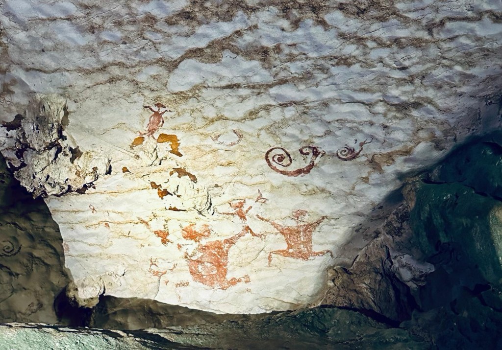
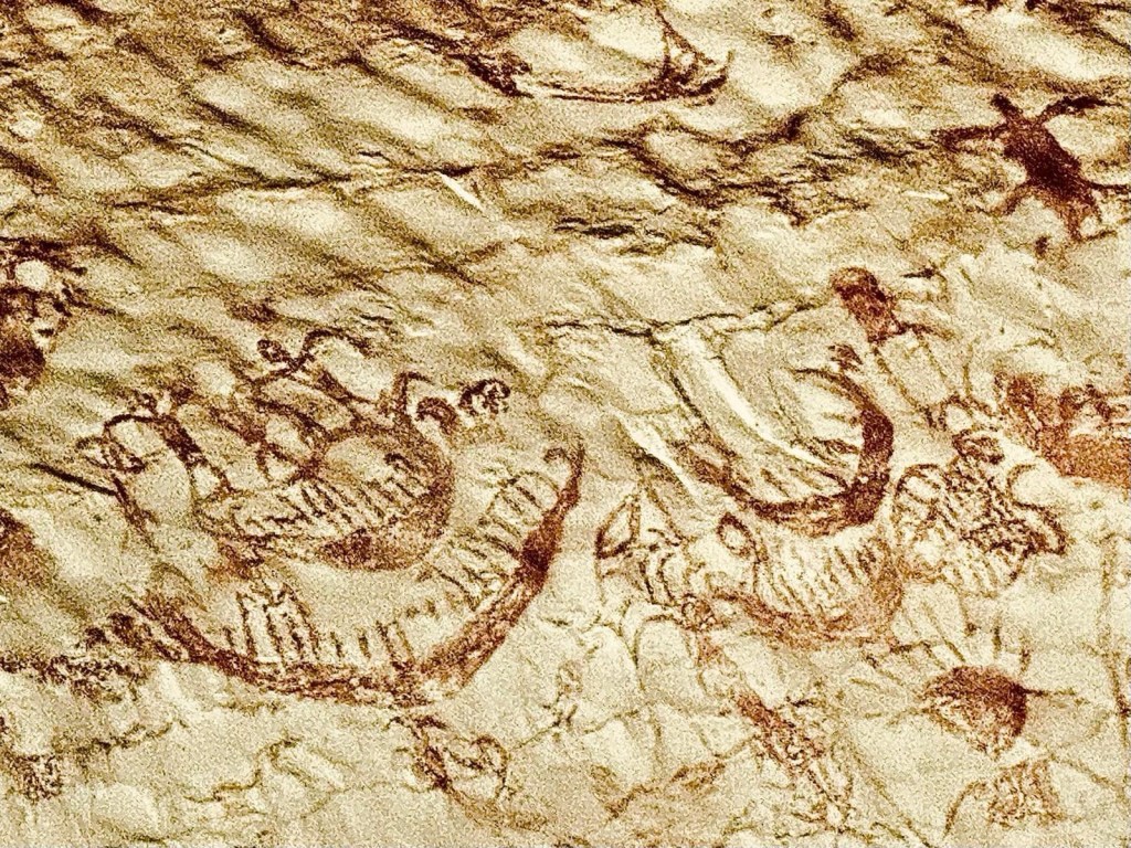
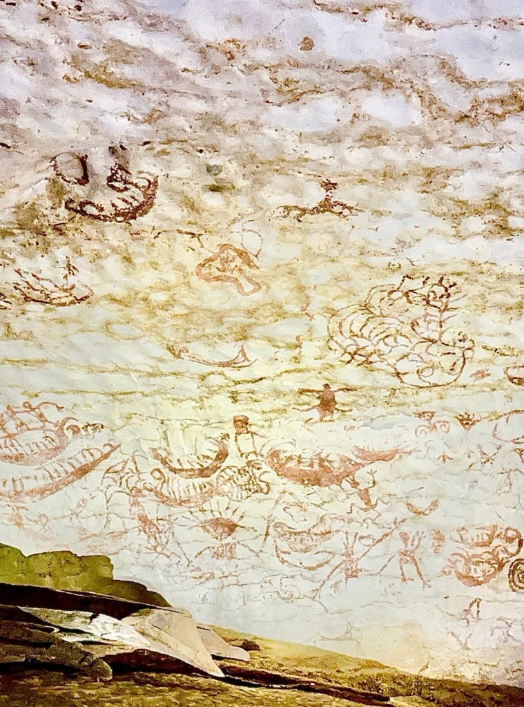
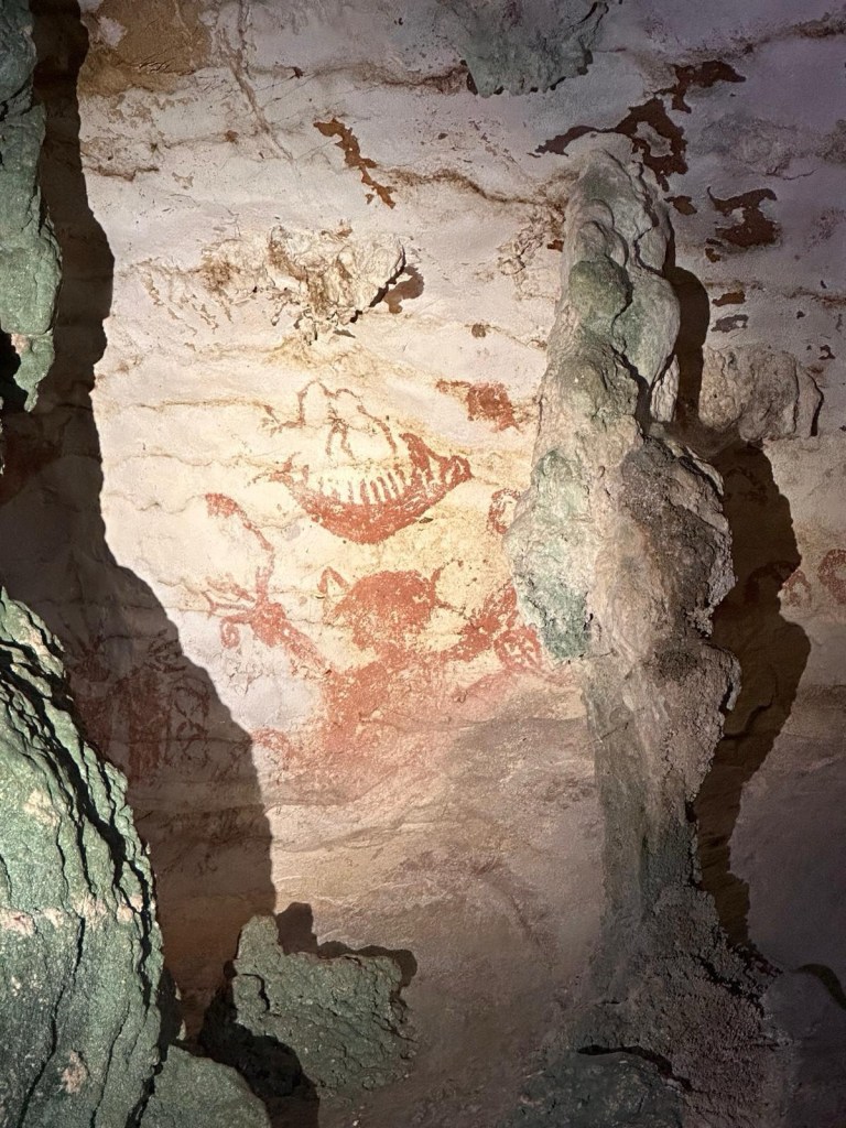
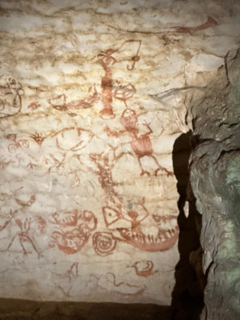
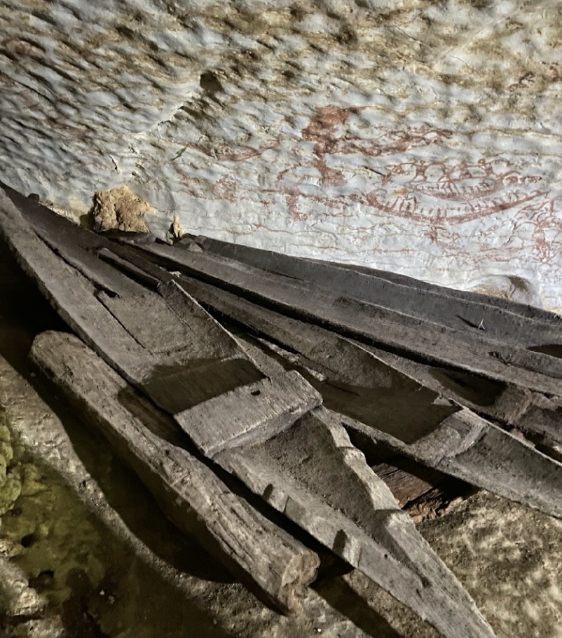
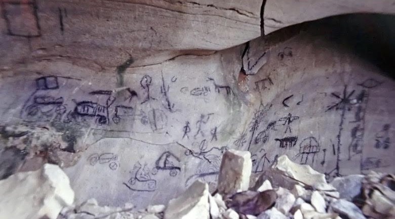
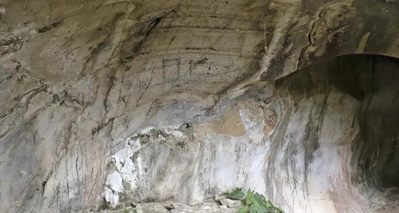
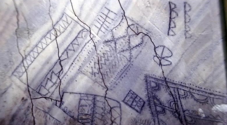
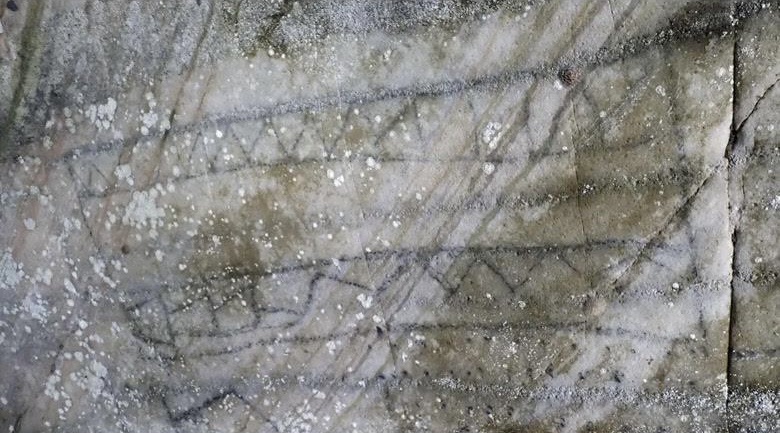
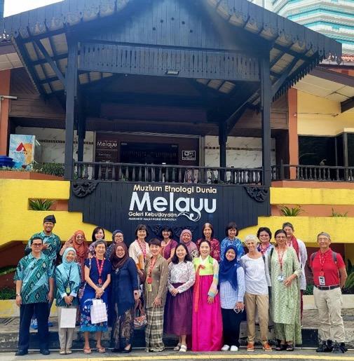
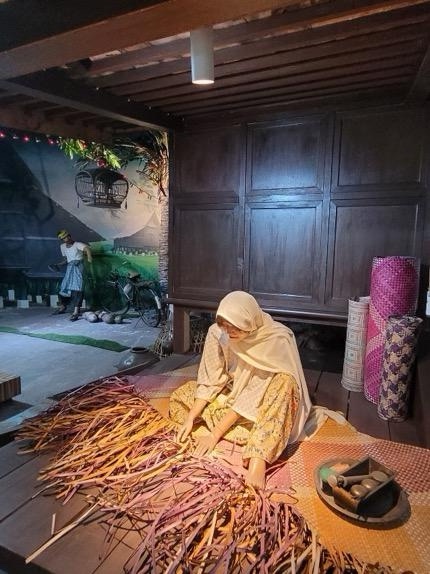
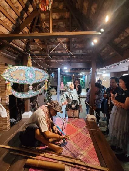
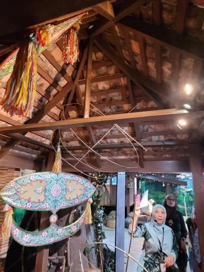
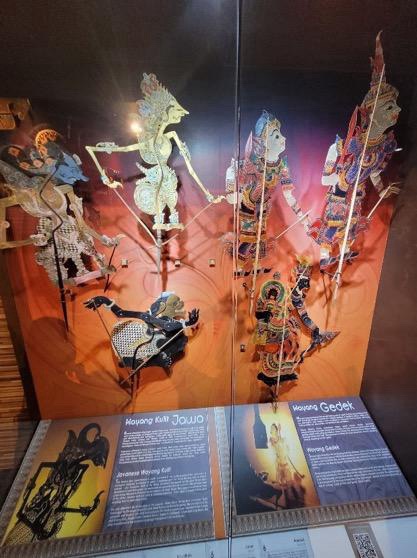
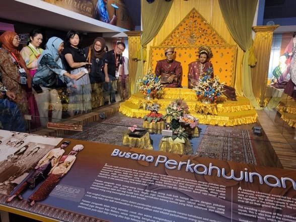
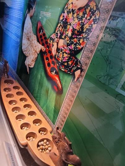
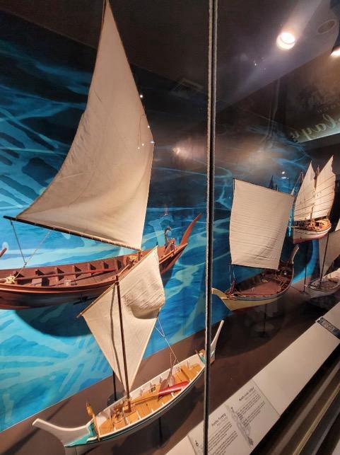
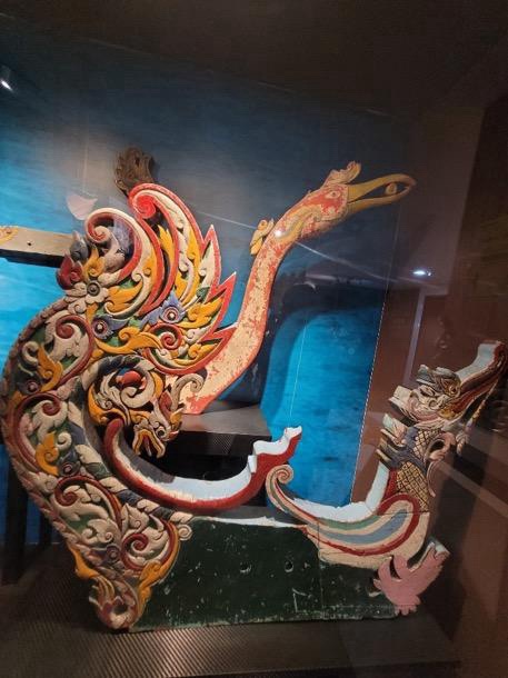
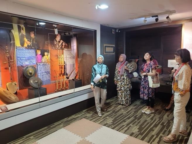
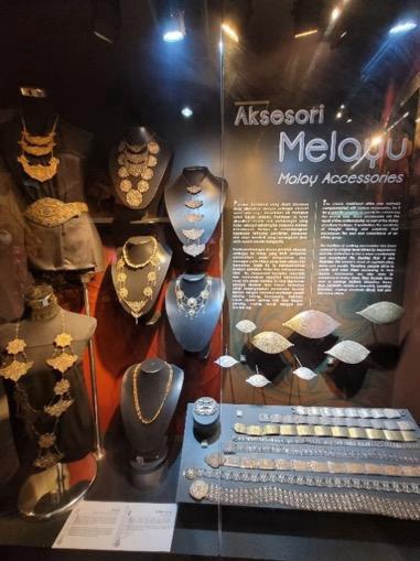
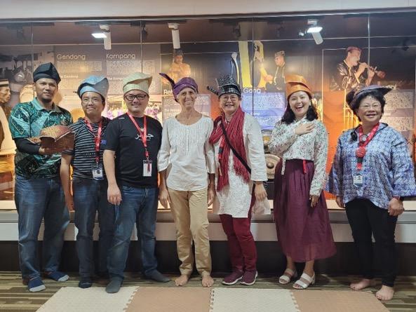
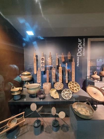
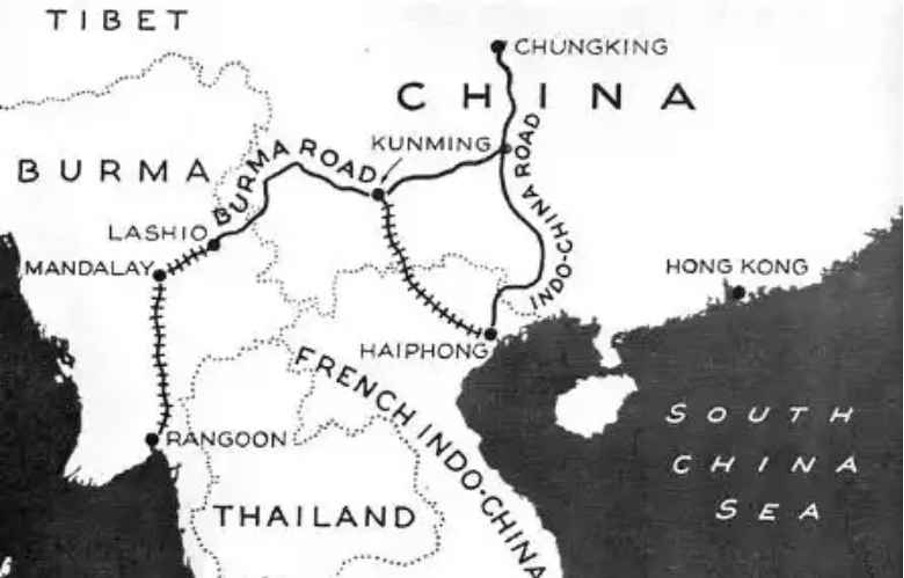
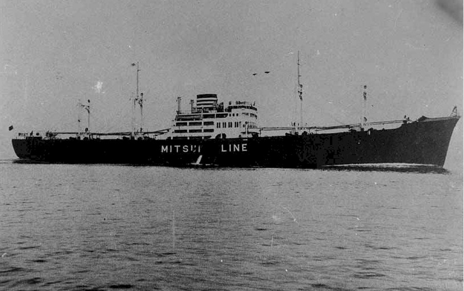
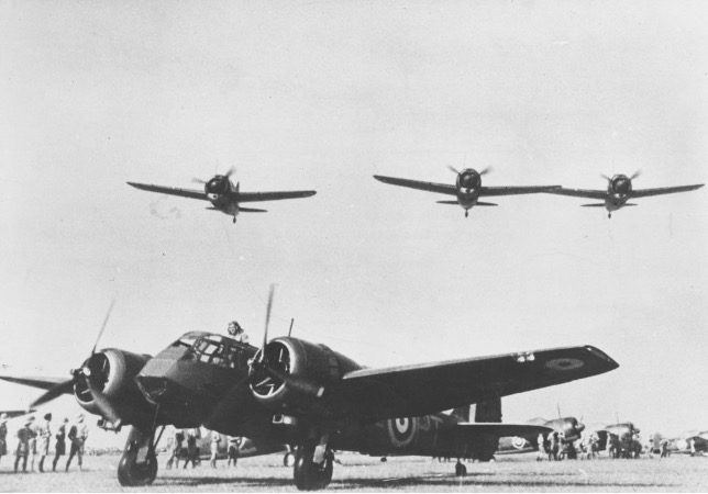
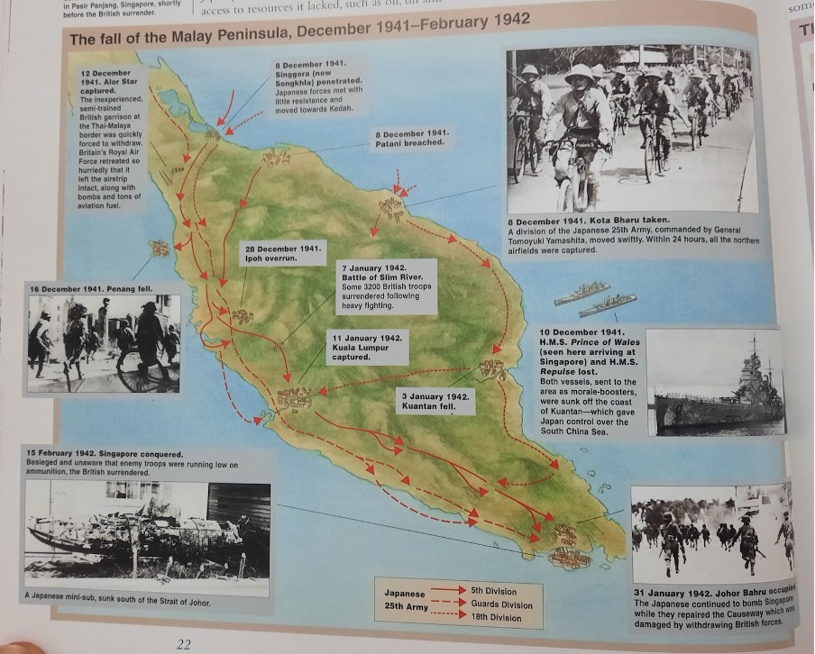
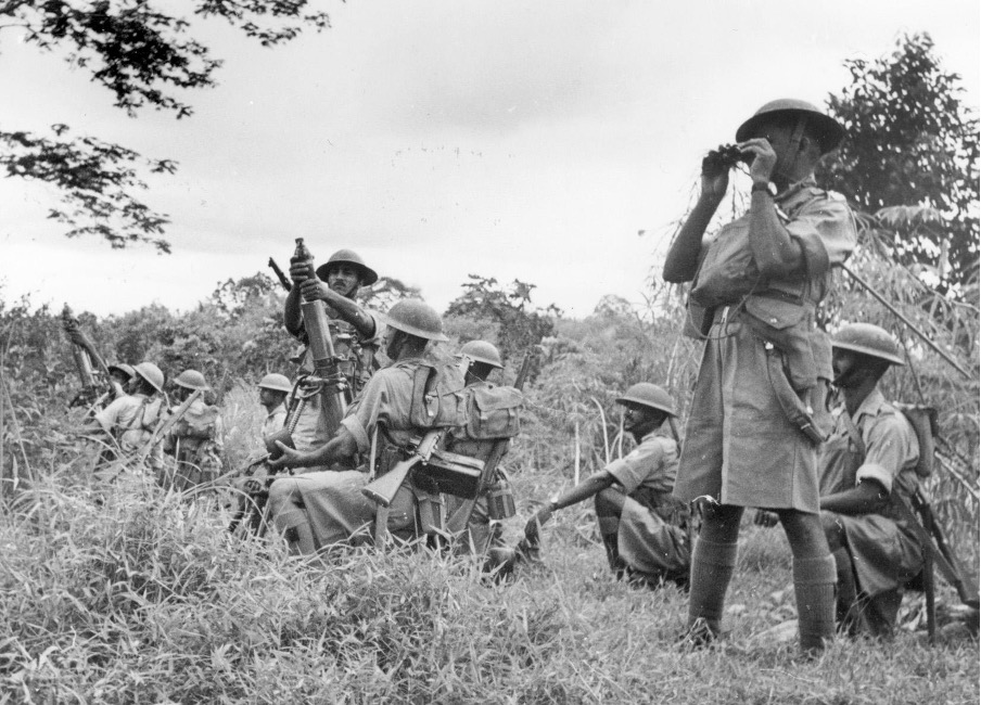
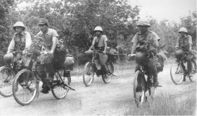
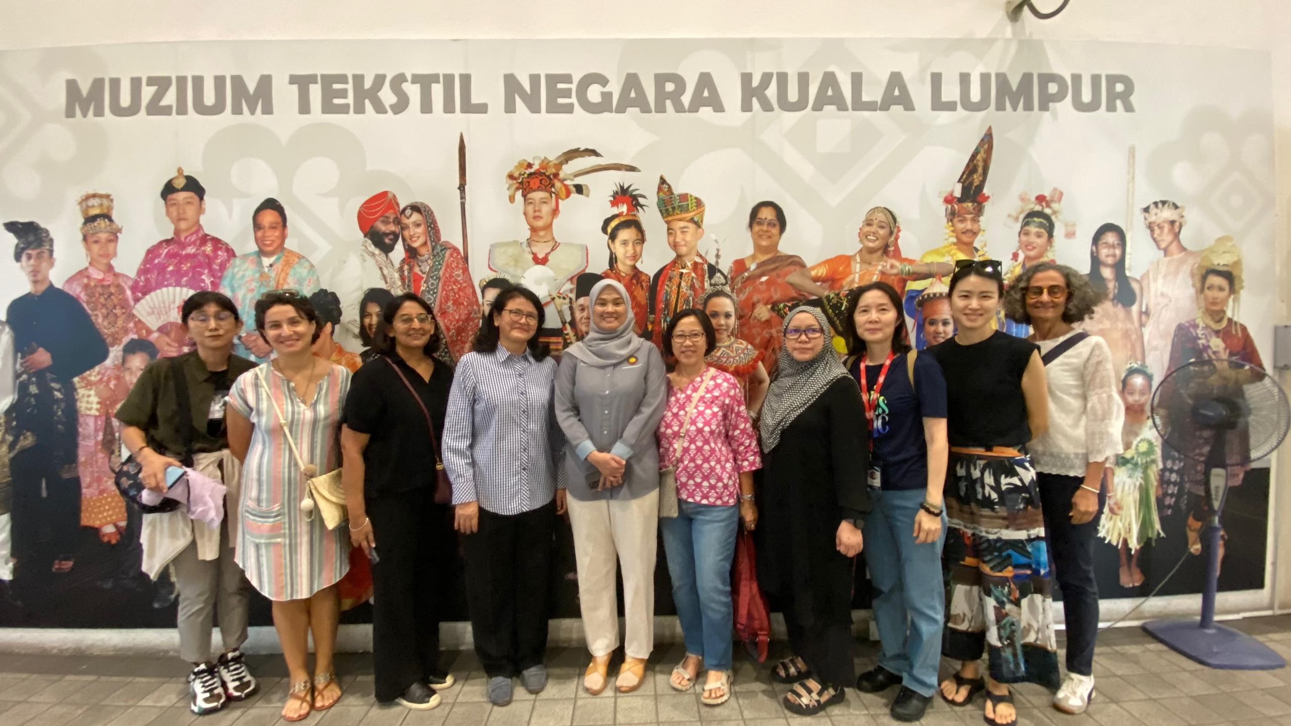

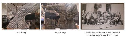
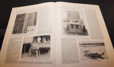
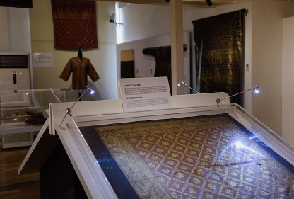
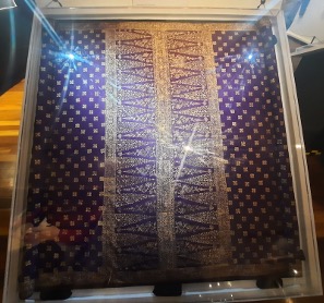
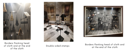
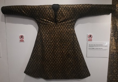
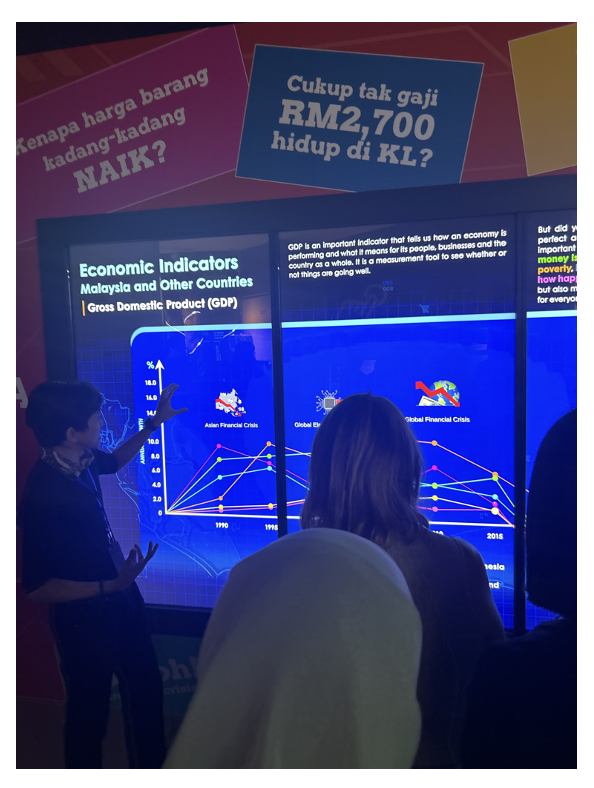


 Statue of Bodhisattva Avalokiteshvara