By Julian Candiah – MV Focus Talk of 24th February 2024
Written By Hani Kamal
Julian Candiah is a collector of antique maps and sea charts from Malaysia and Singapore. He read Engineering at Magdalene College, Cambridge University, and graduated with a First-Class Honours in 1991. He started off as an international banker at Credit Suisse Financial Products, Bear Stearns, JP Morgan, and BNP Paribas in London, Hong Kong and Singapore (1994 to 2007) before joining Merrill Lynch in 2006. In 2007, he was into private equity and investments. In April 2009, he worked pro bono for the state of Penang, acting as the Special Advisor to the Chief Minister. He is currently working on short articles on the history of Johor from the early 19th Century. He has a collection of over 20 sea from the English, Dutch, French and Italian cartographers in his 40 years of collecting. For him collection is genre. A specialised pursuit to acquire old maps involving very distinct set of skills related to acquiring, preserving, and sharing his knowledge about these maps.
The first half of the talk centred around maps about the Straits of Malacca drafted by connoisseurs of sea charts, Sebastian Munster (1530s), Ortelius, Antwerp (1570), Jan Huygen Van Linchoten (1595), De Bry Frankfurt (1598), John Thornton (1701) and Johannes van Kullen (1753). He ended with sharing maps from the English, like Robert Dudley, Florence: Straits of Malacca (1646); Jacques Nicholas Bellin, Paris: Straits of Malacca (1755); Jean Baptiste de Mannevillette, France: Straits of Malacca (1775), and William Heather, London: Straits of Malacca (1803).
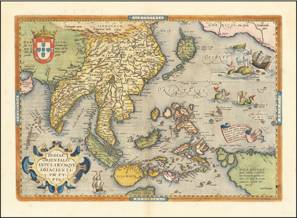
Map 1 First SEA Standardised Atlas
Map 1 This the first South East Asia standardised atlas from 1570 created by Abraham Ortelius. Ortelius collaborated with geographers worldwide to standardise the map, which was then compiled into a book that became one of the most expensive works of its time. It is obviously evident that the sizes of Malaysia, Java, Borneo, Philippines, Japan, Australia, and Papua New Guinea are significantly distorted on the map. The map of Japan has no Hokkaido and Luzon is missing from the Philippines. Interestingly, the map accurately depicts the smaller islands known for clove or spice production.Historically, the strategic port of Malacca was captured by the Portuguese and Dutch due to its essential services such as loading/repair facilities and a readily available food and water supply. These colonial powers then swiftly moved on to the spice islands in search of valuable spices, often referred to us “gold” due to their immense value. Remarkably, current assessments indicate that this historic map holds a significant value of USD4000 or more on eBay.

Map 2 Linchoten Colored Map
Map 2 A full coloured map in 1595, but originally in black and white by Jan Huygen Van Linchoten (1563-1610). He was a Dutch and he spent five years working for the Portuguese as secretary to the Archbishop of Goa. His materials and information were gathered from sailors and he made multiple copies of it. Linchoten is noted to have contributed to the maps of South East Asia in his book “Itenerario”. This map is one of the earliest to depict Singapore as “Sincapura”. Linchoten’s map,obtained secretly through Portuguese sailors, shows seafaring and trading routes; subsequently allowing other European powers to sail safely into the spice islands and breaking the Portuguese monopoly in the spice trade.

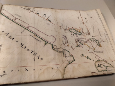
Map 3 Inverted Map in B&W

Map 4 Inverted Map in Color
Map 3 & 4 This map is inverted as the direction is coming in from India. As it was from the Portuguese nothing much was described on Java or Borneo, nor Korea, and Japan is out of perspective. However, mappings of Peninsula Malaysia was very much established. As the map was compiled from sailors, sailing lines were notable. Current value of the Linchoten map is worth USD19,000.

Map 5 First Printed Map of SEA in B&W
Map 5 The first printed map of South East Asia in black and white, and later added with colours.Theodore de Bry was born in 1528 in the Prince-Bishopric of Liège, in the southern Netherlands (today Belgium). He was trained as a goldsmith in his father’s workshop and later as a copper engraver in Antwerp. He moved to London and lived near a printing house, and it was here that he was inspired to produce maps that made his name known. This particular map is decorated with beautiful ornate cartouches on map title and filled with rhumb lines showing bustling crossings. A lot of details were found along the Straits of Malacca indicating robust activities and frequent stops by trading ships. Copy of the de Bry map was auctioned and acquired by the The National Museum of Singapore.
Map 6 English Map
Map 6 Map of Malacca and Singapore by John Thornton, Hydrographer of East India Company, London, 1701. This map is a 100% copy of a Dutch map of Malacca and Singapore. At this time there were free flowing sharing of information and usage of English was beginning to appear in maps. By 1753 maps were printed commercially. The map above has detailed travel routes of the islands, but the island of Singapore was still hardly visible. This map is worth USD12,000-15,000.

Map 7 Series of Maps 1803-1855
Map 7 The series of four maps between 1803 till 1855 illustrate the transformation of Singapore from a relatively obscure island to a thriving trading centre frequent by ships. In earlier maps, Singapore was often spelt as Sincapore and was barely discernible on English maps. Its significance as a trade centre for the British only grew after the British withdrawal from the settlement in Java. By 1855, one can see through the sea charts incorporated with land details such as street names, rivers, etc in detail.

Map 8 Map Made with Vellum
Map 8 Vellum vs paper: These are maps printed on vellum, sheep skin. Vellum was used since early 14th century by Italian navigators, one Bartolomeo Crescenzio (1587-1602) in his Mediterranean quest described vellum and maps, “Bartolomeo Crescenzio: “Nautica Mediterranea”, published in Rome, 1602 and 1607 by Bartolomeo Bonfadino. He was employed in the Naval Ships of Pope Sixtus V and Pope Clement VIII. Professor Ferro wrote as follows;
“There is little uncertainty, for instance, about the materials used and the techniques of execution. Nautical charts were hand-drawn on sheep vellum. The larger ones took up an entire pelt, preserving all of its characteristics and dimensions, i.e., a rectangular shape longer on one end (corresponding to the animal’s neck), where it forms the so-called linguetta [small tongue] or umbilicus; the opposite end was generally attached to a stick around which it was rolled (this explains the tears now visible, caused by forcible attempts to detach it). Of course smaller charts, depicting less extensive areas of sea and land, have other shapes (though still generally rectangular). These were mounted on wooden tablets or cardboard and met a different fate as far as preservation is concerned.
Following the tanning process, the parchment was treated and prepared in a timely manner, according to a procedure that was fully illustrated around the year 1600 by Crescenzio. To bleach its inner side (the side on which the design was to be traced) and to make it smooth, the vellum was rubbed with white lead and dried with a white cloth. Then the leftover skin bits were boiled in water until the mixture became thick and viscous. Another cloth (or a sponge) soaked in this fluid was then passed all over the well-stretched parchment. Once dry, this was rubbed with white lead a second time so as to render the surface perfectly white and smooth, eliminating any unevenness that might impede drawing or writing. The outer side, on the other hand, was left thick and rough, thus serving to protect the chart, at least partly, from temperature variations, humidity, and salinity.”
According to the speaker this map is worth USD500,000.

Map 9 Robert Dudley’s First Sea Chart
Map 9 First Sea chart atlas by Robert Dudley 1646, is perhaps the most rare and revolutionary during that time. It was the first sea atlas in the world, first to use various sophisticated seafaring engineering and created with accuracy reflecting his extensive knowledge as a cartographer. It was the first to reflect magnetic deviation, first to detail water currents and prevailing winds. It was also the first to explain the advantages of ”Great Circle Sailing” (shortest distance between two points of the globe). A magnificent and very rare sea atlas, currently worth USD 1 million.
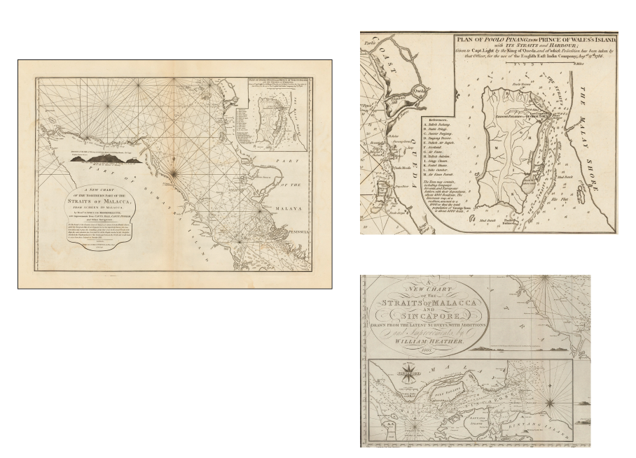
Map 10 Series of Maps by William Heather, London
Map 10 The first important 19th century sea chart of the Straits of Malacca was mapped by William Heather (London, 1803) depicts the status of EIC’s role in Penang and along the Straits of Malacca. The Straits was the busiest shipping highway at that period and so sea charts were utmost important. For the British this was the gateway between India and the Far East. Maps with details of rhumb lines, sandbanks, mountains, street names, total population, etc were very useful. Singapore was hardly noticeable during the early 19th century and the maps on Singapore were totally wrong in shape and size in the earlier maps. This map was impressive at that period of time and soon ran into many revisions due to its deficiencies and lack of information about the Straits. Current value at USD17,000.
Conclusion
After going through the extensive history of sea charts, we tend to reflect on the maps found at Gallery B, Muzium Negara; Almost all of us referred to those maps as depicting Malacca’s popularity and the crucial role the maps played to European explorers sailing to Malacca looking for spices. However it is worth noting these were not intricate sea atlases or charts but rather simple maps highlighting the significance of Malacca during that era. Consequently, the portrayal of the entire Malaysian Peninsula as Malacca underscored the paramount importance attributed to this strategic location, with no information provided on other regions of the peninsula.
Three books were recommended by the speaker in reference to antique maps:
- Early Mapping of South East Asia by Thomas Suarez
- The Cartography of East Indian Islands by Dr David E Parry
- Maps of Malaya and Borneo by Dr Frederic Durand
Reference:
MV Focus Talk by Julian Candiah at the MV Room, JMM on 24/02/2024
https://www.swaen.com/mapping-of/south-east-asia/early-maps-of-south-east-asia
https://www.swaen.com/mapmakers/robert-dudley

Very interesting and welcome research in short prose. Thanks. Hans Holst, dr. phil.