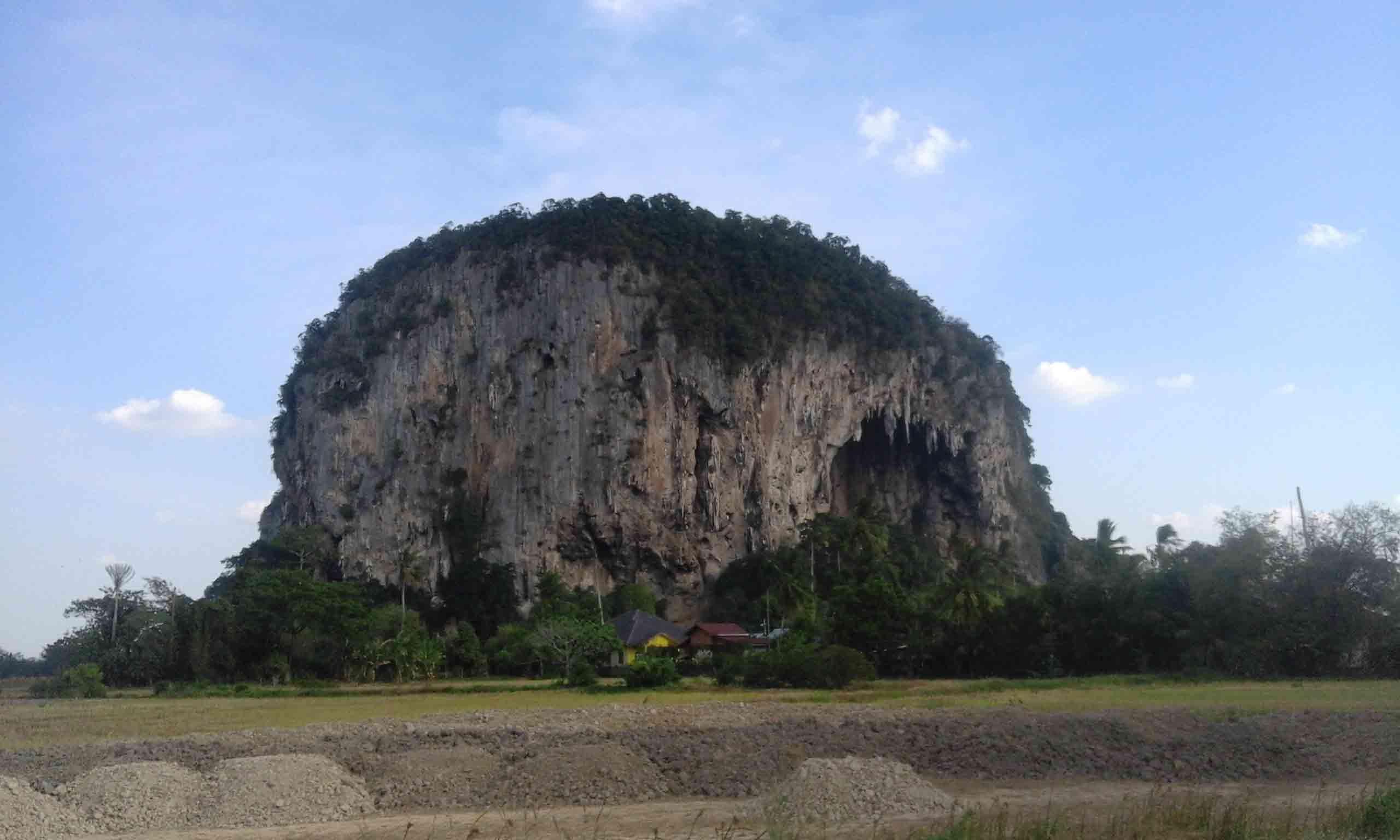
Kodiang is a small town situated in the Kubang Pasu district of Kedah, in the northwestern part of Peninsular Malaysia. A nearby limestone outcrop known as Bukit Kaplu has a large rock shelter called Gua Berhala (Peacock, 1959, p. 137) on its north face. The site was visited in 1929 by Ivor H. N. Evans, who found several sherds of cord-marked pottery and a few pieces of antler, including one that had been worked (Peacock, 1959, p. 137).
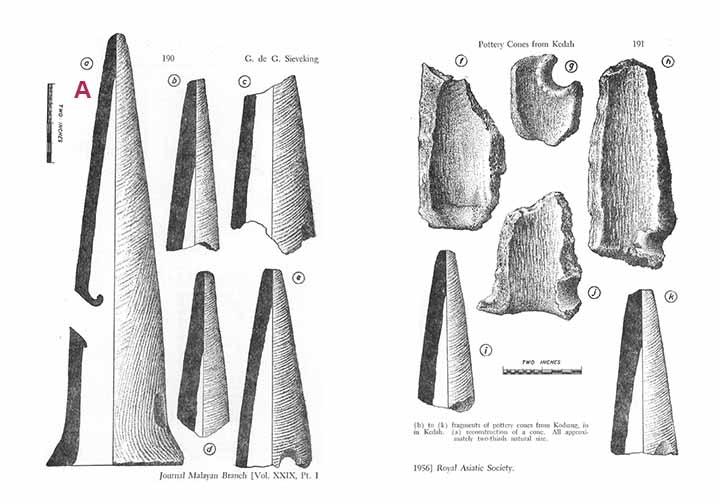
It was, however, only in 1951 that the conical ceramic objects that Kodiang is best known for were discovered. These were found by Peter D. R. Williams-Hunt during his visit to the site (Peacock, 1959, p. 137). Williams-Hunt published his findings the following year, describing the unusual conical artefacts as follows:
Fragments of about thirty cone-shaped objects of well fired clay each about fourteen inches in height, decorated with fine cord markings and pierced by two or three holes. At least one shows signs of having had a square foot; others are more roughly finished. The exact function of these objects, remains speculative. They are not kiln rests and it can only be suggested that they have some ritual significance possibly in association with Buddhism.
(Williams-Hunt, 1952, p. 182)
Subsequently, these pottery cones were studied by Gale de G. Sieveking and a more thorough assessment of the artefacts was made. Sieveking (1955, pp. 189, 192) elaborated on the technical aspects of the cones’ manufacture, noting, for instance, the way the cones were formed and decorated, as well as the firing conditions. Naturally, this was followed by speculations regarding the function of the cones.
Sieveking (1955, p. 192) entertained Willaims-Hunt’s idea that the cones may have had a ritual function, perhaps for the burning of incense, on the basis of local enquiry. Two counter arguments were then presented – the crude manufacture of the cones, and the absence of traces of burnt incense on the artefacts (Sieveking, 1955, pp. 192-193). It was then suggested that the cones might have been part of a potter’s toolkit. The pointed end could be stuck into the ground, whilst a newly formed vessel could be placed on its ‘rim’, to allow it to dry, or to be decorated (Sieveking, 1955, p. 193). It was further argued that the holes in the cones may have been “slots for the insertion of pieces of wood, which could be used to rotate the cone” (Sieveking, 1955, p. 193).
Fragments of pottery cones found by Sieveking at Kodiang. Labelled ‘A’ is his reconstruction of a cone. Image credit: Sieveking (1956, p. 190-191)
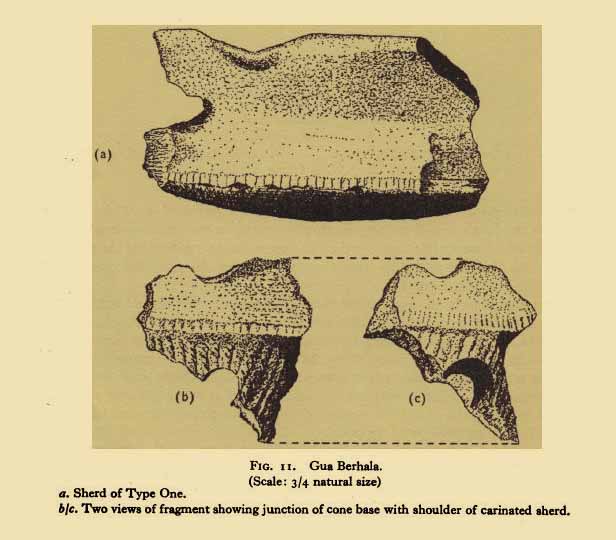
Williams-Hunt and Sieveking’s speculations hardly impressed B. A. V. Peacock, who considered the former a lame suggestion that was made “perhaps in despair”, and the latter “hardly more credible than the one he intended to supplant” (Peacock, 1959, p. 138). Peacock (1959, p. 139) made the significant observation that the “ends are always broken and without a trace of a finished trace”, thus associating these artefacts with the other sherds from the site. He had the fortune of finding at Gua Berhala “a fragment combining part of the base of a cone, including the upper half of one of the holes, with the carinated shoulder of a bowl”. Therefore, Peacock (1959, p. 140) was confident enough to propose that the cones belonged to a type of tripod vessel. Thus the ‘mystery’ of the Kodiang pottery cones was solved.
Fragment of cone attached to pottery vessel, found by B.A.V. Peacock at Gua Berhala. Image credit: Peacock (1959, p. 139)
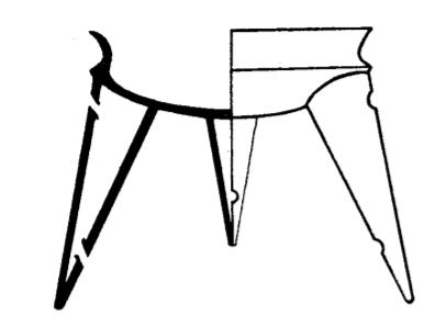
Reconstruction of the tripod vessel by B.A.V. Peacock. Image credit: Peacock (1959, p. 140)
As a final note, whilst the discovery of the pottery cones at Kodiang was unique at the time, tripod vessels were subsequently discovered in other parts of Southeast Asia. These vessels were found, for instance, in 11 of the 44 Neolithic burials excavated at the Thai site of Ban Kao during the 1960s (Sorensen & Hatting, 1967, cited in Leong, 2003, p. 173); during the 1977 and 1979 excavations at Jenderam Hilir, Selangor (Leong, 2003, p. 178); and as an “isolated free find” in Satun, southern Thailand (Chaiwat, 2007, cited in Ahmad Hakimi, 2008, p. 15).
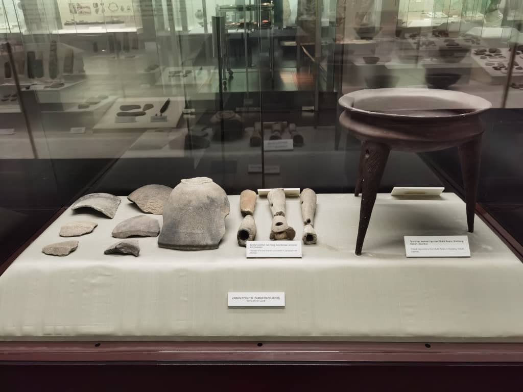
A replica of a Kodiang tripod vessel at Muzium Negara can be seen at the rightmost. On its left are shards of tripod legs uncovered at Jenderam Hilir, Selangor. Image credit: Ong Li Ling
Leong, S. H., 2003. Tripod Pottery in Mainland Southeast Asia. In: J. N. Miksic, ed. Earthenware in Southeast Asia: Proceedings of the Singapore Symposium on Premodern Southeast Asian Earthenwares. Singapore: Singapore University Press, pp. 173-186.
Peacock, B. A. V., 1959. A Short Description of Malayan Prehistoric Pottery. Asian Perspectives, Sa-huỳnh Pottery Relationships in Southeast Asia, 3(2), pp. 121-156. [Online] https://www.jstor.org/stable/42928913 [Accessed: 9 June 2021]
Sieveking, G. d. G., 1956. Pottery Cones from Kodiang (Kedah). Journal of the Malayan Branch of the Royal Asiatic Society, 29(1), pp. 189-194. [Online] https://www.jstor.org/stable/41503209 [Accessed: 9 June 2021]
Williams-Hunt, P. D. R., 1952. Recent Archaeological Discoveries in Malaya, (1951). Journal of the Malayan Branch of the Royal Asiatic Society, 25(1), pp. 181-190. [Online] https://www.jstor.org/stable/41502945 [Accessed: 12 May 2021]
In this Series
Click HERE for a list of articles in the A-Z at ‘Muzium Negara’ series.
Photo source : The Star / All quiet here – 12 July 2021
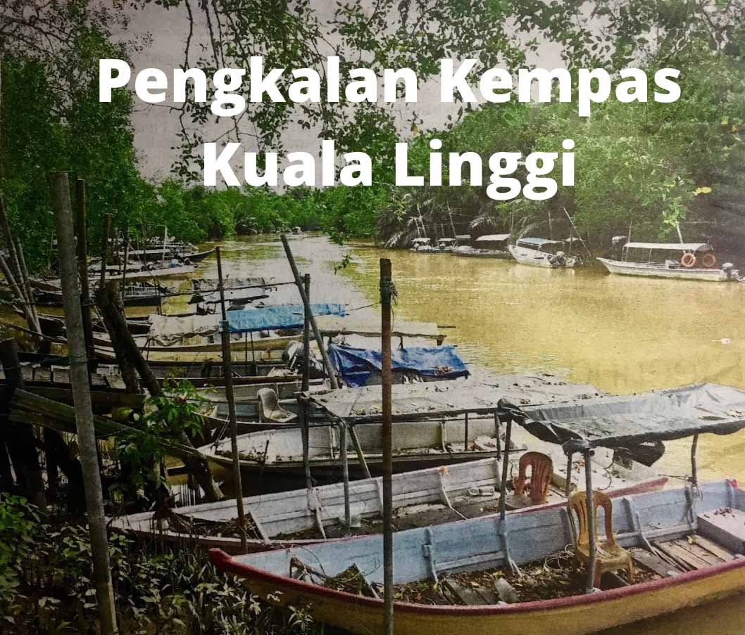
Sungai Linggi is one of the major rivers in the state of Negeri Sembilan. The river originates near the hilly purlieu of Pantai, just outside of the capital, Seremban, and it follows a southwestern path across the state to the river mouth in Melaka, an axial length of about 83 km. The name ‘Linggi’ is derived from a Bugis word, which means ‘the stem or bow of a ship’. Pengkalan Kempas and Kuala Linggi are both located along Sungai Linggi – the former is located near the confluence with Sungai Rembau while the latter is at the estuary where the river empties into the Straits of Malacca.
History
Sungai Linggi, circa 1834 / Photo source : Wikimedia Commons
As far back as the 14th century CE, Sungai Linggi was the main route in and out of Sungai Ujong (Seremban today), flowing from the interior to the coast. It was the only means of entry and circulation for traders. It was said that Parameswara used this waterway to reach Sungai Ujong prior to the founding of Melaka. Sungai Ujong later came under the control of the Melaka Sultanate. The Minangkabau and Bugis who were the earliest settlers in Negeri Sembilan used it to transport jungle produce and tin to Melaka when it became an entrepot. In a plot to get back in Sultan Mahmud Shah’s favour, Hang Tuah made his voyage to Pahang and succeeded to ‘charm’ the beautiful Tun Teja with some help from the ‘magical love potion’ which made her agree to accompany Hang Tuah on his boat to Melaka. However, Tun Teja found out later that she was betrayed by Hang Tuah. She eventually agreed to marry Sultan Mahmud Shah. For the mission accomplished, Hang Tuah was conferred the title ‘Laksamana’ (admiral).
When the Johor Sultanate started to lose its grip on Negeri Sembilan, the Bugis from Riau under Daeng Kemboja, made inroads into the state and settled at Linggi. In 1756, the Bugis laid siege to Melaka, which was then ruled by the Dutch. In retaliation, Dutch reinforcement attacked the Bugis’s base the following year. The Bugis then decided to call a truce and both warring parties agreed to build a fort at the estuary of Sungai Linggi (for more information, check section on Kuala Linggi below). After a long period of peace, in 1784, the Bugis under Sultan Ibrahim of Selangor mounted another attack on Dutch Melaka. He sailed up Sungai Linggi to Rembau and rounded up Minangkabaus fighters from Rembau and Pedas for the attack.
After the Dutch left Melaka, Negeri Sembilan was divided into two camps – Dato Kelana and Dato Bandar –that fought to control Sungai Linggi, which had become the major trade highway. The Chinese started mining around Rasah in 1828 but left the tin mines to move to Selangor because of trouble with the Malays. They returned in 1830 and by 1874, there were 15,000 Chinese in Sungai Ujong; by then, it was a major tin mining area in the country.
On 21 April 1874, Dato Kelana and Dato Muda Linggi signed an agreement with the British seeking their protection and recognition of Dato Kelana as the ruler of Sungai Ujong. In the process, Dato Bandar surrendered to the British and he was sent to exile in Singapore. After the ouster, the opposing camp was now led by Yamtuan Antah of Seri Menanti. They started a move to drive the British out of Sungai Ujong and this paved the start of the Sungai Ujong War in December 1875. By the 22nd of December, British forces captured the stockades at Bukit Putus and Ulu Bandol and reached Yamtuan Antah’s stronghold at Seri Menanti where they burned his palace, Istana Pulih, to the ground.
Five years into the British Residential system in Sungai Ujong, Isabella Lucy Bird, Victorian explorer, naturalist and writer (international traveller and adventure blogger by today’s classification) visited Sungai Ujong via Sungai Linggi. In her book ‘The Golden Chersonese and the way thither’ published in 1883, she wrote that she visited the tomb of a ‘great prophet’ who was slain in ascending the Linggi (for more information, check section on Pengkalan Kempas below). She then visited ‘Serambang’ (Seremban) and she was shown around the town by the host, British Resident Captain Murray. She also stayed at a sanatorium located three miles away in what the Resident called ‘Plantation Hill’. Isabella also wrote of her interest to stay longer in order for her to make acquaintance with a colony of ants!
The distance between Port Dickson town and Pengkalan Kempas is about 33 km via Federal Route 5. Pengkalan Kempas [1] is a one-street town and just a stone’s throw from Sungai Linggi. The first attraction of the town is the jetty (see first photo), which is located just before the town. Sungai Linggi is well known for giant freshwater prawns. There are plenty of boats available for rental to catch prawns. Besides that, visitors can take eco tours exploring the river, mangrove forest and catch a glimpse of saltwater crocodiles. It is reported that the population has reached 3,000. Isabella also encountered a crocodile, which she called an alligator on her cruise up the river (incidentally, a crocodile is larger than an alligator). In the olden days, this jetty was a bustling place. Tax was collected from traders and it was a key landing point for Chinese settlers predominantly from the Fujian Province. The town folks are very proud of this history that they had erected a sign to proclaim the landing site.
Directly opposite the jetty is the Police Station, which was established in 1920. It also served as a tax collection centre. The town is flanked on either side by pre-war shophouses but most of the shops are closed. The town used to be the pit stop for motorists en-route to Melaka. At the end of the street is SJK (C) Yik Hwa, a Chinese primary school that was opened on 15 November 1923. In 2018, it had an enrolment of only 49 pupils. Further up, located on a hillock is the Chinese Methodist Church, built in 1928. The worship service is on every Sunday at 4.00 pm.
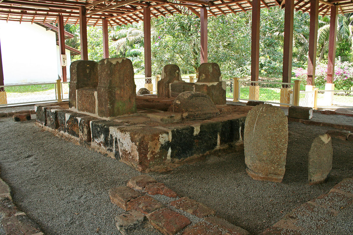
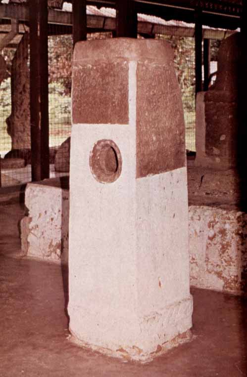
Across the road from the church is the main drawcard of the town, the Pengkalan Kempas Historical Complex. When Isabella made the visit in 1880, it was known as Keramat Sungai Udang (prawn river shrine). Today, the complex consists of the tomb, a four-sided inscription tombstone with a cylindrical shaped hole at the centre and a number of ancient stones/megaliths.
According to the epitaph, the tomb is the final resting place of a saint, Sheikh Ahmad Majnun (also spelt as Ahmat Majanu), and it is dated to the 872 Hijrah era, corresponding to the year 1467/1468. It is also written that the ‘saint’ would by no means have been a holy man but on the contrary a traitor who was executed after an unsuccessful attempt at the life of Sultan Mansur Shah. Many scholars had come to study the tomb and offered their views. However, many questions remain unanswered until today. Who was Sheikh Ahmad Majnun? Was he a saint or a traitor? If he was a traitor, why was he commemorated with a true Muslim burial? Incidentally, the word ‘Majnun’ means ‘crazy’ in Arabic. As to the hole at the centre of the tombstone, many believe it is an olden day ‘lie detector’. Anyone who dares to take the challenge, do it at your own peril. Based on the date of this tomb, it is one of the oldest Muslim tombs in the country.
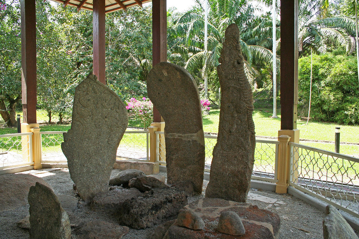
The megaliths found at the site are menhirs (freestanding stones) believed to be from the 2nd/3rd century CE; the locals called them ‘batu hidup’ or living stone. The most well known is the cluster of three erected inscription stones which are nicknamed after their distinctive shapes i.e rudder, spoon and sword. The rudder shaped stone has inscriptions of a horse, tiger, barking deer (known locally as kijang) and probably an elephant’s trunk. Interestingly, the sword stone has the Arabic word ‘Allah’ that sticks out a mile. This leads to more baffling mystery as the stone predates Islam. However, J.G. de Casparis concluded that the sword stone post-dates the introduction of Islam into the Malay Peninsula and probably only dates back to the middle of the fifteenth century.
Megaliths in the Malay Peninsula are mainly found within the border of Melaka and Negeri Sembilan i.e in Alor Gajah district in Melaka and in Kuala Pilah, Rembau and Tampin districts in Negeri Sembilan. These upright stones are around 2 to 8 feet in height and arranged either in a cluster of one large menhir surrounded by smaller stones or in pairs and aligned side by side with one stone larger than the other. These stones are erected on earth mounds. Excavation of the megalithic site at Kampong Ipoh in Tampin, Negeri Sembilan by the Museums Department in 1981, found no skeletal remains in the megalithic area. The excavation proved that the megalithic groupings in Malaysia were not the sites of historic or prehistoric burial as believed by the local people. Research into megaliths in our country is rather scarce. Until today, the purpose and age of the megaliths remain a mystery. Some of the megaliths from the Tampin excavation are on display at the grounds of the National Museum in Kuala Lumpur. Another place to see these ancient stones is Laman Megalit (Megalith Park) inside Taman Putra Perdana in Putrajaya. The park which was completed in 2003 has over eighty erected megaliths and these stones were discovered by Petronas during work to lay a gas pipeline at Kampung Gelanggang in Negri Sembilan in 1989. Prior, the stones were displayed at the Petronas Megalith Garden located between Dayabumi and Kuala Lumpur Railway Station in the city.
The next destination is Kuala Linggi [2] in Melaka, which is about 15 km from Pengkalan Kempas using Federal Route 5 heading to Port Dickson. Upon reaching Kampung Sungai Raya, exit to join N143 Jalan Pasir Panjang-Kuala Linggi. In my article about Lukut, I have mentioned Raja Sulaiman of Sungai Raya who had wanted to be liberated from the clutches of Raja Bot at Lukut but he failed to make a breakthrough. At the 12 km point, the Kuala Linggi Bridge would be in full view. This bridge was officially opened on 10 July 1990 by Tun Dr Mahathir when he was the fourth Prime Minister of Malaysia. The bridge serves as a border crossing between Negeri Sembilan and Melaka and it is currently a popular spot for fishing. A short distance from the bridge and located on top of a hill at the mouth of Sungai Linggi is Kota Bukit Supai / Sepoy Hill Fort. The word ‘supai’ may not be Malay but a Persian or Hindi word, which has the same meaning as ‘sipahi’, which means ‘sepoy’ or an infantry soldier. The sepoy guarding this fort were trained to use weapons, initially matchlock muskets and later flintlock, which was brought to the East by the Dutch. The Dutch name for the flintlock weapon was ‘snaphaan’, passed on to Malay as ‘senapang’ (rifle in English).
As mentioned earlier, the fort was built jointly by the Bugis and Dutch after the restoration of friendly relations and a peace treaty was signed on 1 January 1758 at the completion of the fort. The terms of the treaty were heavily in favour of the Dutch – first, they had full control of the fort, and second, they controlled all ship movements on Sungai Linggi and collected taxes from ships transporting tin quarried in the interior of Sungai Linggi and Sungai Rembau. The fort is rectangular, measuring 167 feet by 150 feet, fortified with bastions at every corner and the two entrances, landward and seaward. The walls were about eight feet high and a moat surrounded the fort. The Dutch named the fort, Fort Filipina, after the daughter of Jacob Mosel, the Governor General of the Dutch United East India Company (Dutch name, Vereenigde Oost Indische Compagnie, in short VOC) at that time. About a year later, the Dutch abandoned the fort.
Between 1974 and 1975, the Museums Department initiated some conservation works on the remains of the fort. Buildings that were built within the fort and the seaward passageway that connected the fort and the landing stage at the beach had disappeared. The fort was later gazetted as a historical monument under the Antiquities Act 1976. As one of the ways to attract visitors to the site, the Alor Gajah Town Council have built a seafood restaurant on stilts and linked the eatery to the fort by a walkway. One wonders what would be the probability that the path of this walkway, the same as the original seaward passageway that had disappeared?
T.A.G Marine Sdn Bhd (TMSB) is a local company involved in the shipping and maritime industry. They are licensed port operator/service provider and operated the Kuala Linggi International Port (KLIP) when it was gazetted in July 2006. The port is situated near the river mouth of Sungai Linggi. Since then, it has been providing ship-to-ship cargo transfer services and it has attracted a host of large carriers and ships. One of its major successes was Gazprom’s first ship-to-ship transfer of LNG cargo on 6 December 2014. In 2019, the company announced a RM15 billion KLIP expansion project. The land reclamation is expected to be completed in 48 months. This raised concern by the local communities for the protection and preservation of the environment and wildlife. In a press report on 13 March 2021, the Melaka Menteri Besar has said that it will ensure that the environmental impact assessment (EIA) will be carried out prior to the construction of the KLIP.
Unknown to many, the Linggi-Rembau estuary is blessed with a firefly colony. The Negeri Sembilan Tourism started to promote it as an attraction in 2008. Since then the Pengkalan Nelayan Sungai Timun [3] jetty in Rembau district has seen an increasing number of both local and foreign tourists. An added feature of the Sungai Timun fireflies is the combination of both the species that practice synchronous flashing and the non-synchronous flashing species. The former is known as Pteroptyx tener and the latter are Pteroptyx assymmetria and Pteroptyx malaccae. Based on studies done, there are 2200 identified types worldwide and in Malaysia, there are about 100 identified types. The local name for fireflies is ‘kelip kelip’, which means to flicker. Its life cycle consists of eggs, larvae, pupae and adults. It takes about a year for it to grow to adult size of 1-2 cm and adults only live for about two months. Fireflies in the mangrove forest congregate on the Berembang trees (Sonneratia caseolaris/mangrove apple) as a source of food and protection from the sun. Other mangrove trees that support the population of fireflies are nipa palms, nibong palms and ferns. Incidentally, July is the month where World Firefly Day is celebrated and this year, it was on 3-4 July. The theme for this year’s celebration is ‘Watch us, don’t catch us!’ which is to promote firefly tourism. It is hoped that the mangrove forest at Sungai Linggi and Sungai Rembau will be protected and preserved so that the giant freshwater prawns, saltwater crocodiles, fireflies, mangrove trees and the livelihood of the communities will continue.
From Kuala Lumpur city centre, use the North South Highway (E2 South) and exit at Exit 223 Pedas Linggi. After the toll, head to Linggi. At Linggi, join Federal Route 5 to Pengkalan Kempas. From Pengkalan Kempas to Kuala Linggi, use Federal Route 5 and head to Port Dickson. Upon reaching Kampung Sungai Raya, exit to join N143 Jalan Pasir Panjang-Kuala Linggi. To go to Pengkalan Nelayan Sungai Timun from Pengkalan Kempas, join Federal Route 5 and head to Linggi and Lubok Cina. Before Lubok Cina, watch out for the turning to N116 Jalan Sungai Timun. The jetty is further ahead.
In this Series
Please click HERE for a list of articles in the ‘A Very Rough Guide’ series.
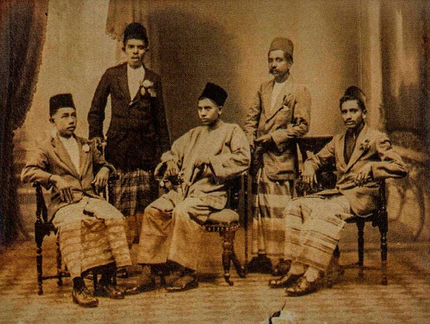
Jawi Peranakan, or previously known as Jawi Pekan, refers to a community that originated from social amalgamation and assimilation – a product of intermarriage between local Malay women and Muslim men from Southern India. Although this community has long existed especially in Kedah, Melaka and Perak, it is believed that the Jawi Peranakan in Penang grew in number when Captain Francis Light established Penang in 1786, which attracted numerous merchants and migrants from the Malay Archipelago, China, India, Arabia and Europe. The merchants and migrants from India and Arabia established a new society in Penang known as Jawi Pekan. Many of the merchants established their businesses in George Town and settled down; some of them married local women, others brought their wives, and the sojourners eventually turned into settlers.
Back then, the term Jawi Pekan referred to the interracial marriage between Malay women and Arabians, Tamils, Bengalis, Punjabis, Gujaratis, or Afghans, leading to assimilation with Malay culture. Additionally, the term was also used for Muslim people not of local Malay descent. However, in 1871, the term Jawi Pekan was dropped by the British in the Census of Straits Settlements and replaced with Jawi Peranakan; the reason being the said term was not specific and did not use the term ‘Peranakan, which supposedly referred to locally born people with mixed local and foreign ancestries.
At first, the intermarriages only took place between wealthy merchants and aristocratic Malay women. However, a change happened in Penang when intermarriages also began to involve non-aristocrats Indian Muslims and local Malay women. This was because many Indian Muslims migrated to Penang under the British and with the opening of Georgetown as a port of call under the East India Company (EIC). Apart from mixed marriages with Indian Muslims, Malay women in Penang also married Jawi Peranakan from Kedah who migrated to Penang. In addition, the Indian Muslim migrants married local Malay women since they shared the Islamic faith. It is believed that because of the shared religious belief system, it enabled the affluent Indian Muslim tradesmen and merchants to be accepted among the locals, and this resulted in the intermarriages. The long process of amalgamation and assimilation of Malay culture experienced by this society over the years had caused most of the new generation of Jawi Peranakan to adopt many Malay customs and traditions, and no longer maintain their cultures from South India. They were also fluent in speaking the Malay dialect of Penang (Tanjong), while also being able to converse fluently in both English and Tamil languages.
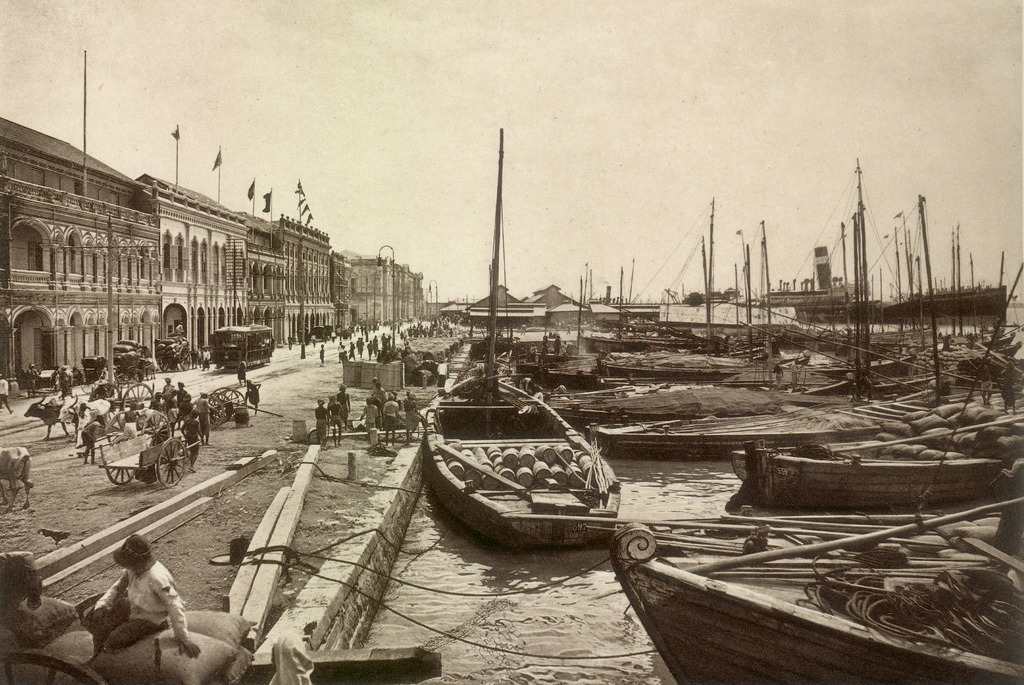
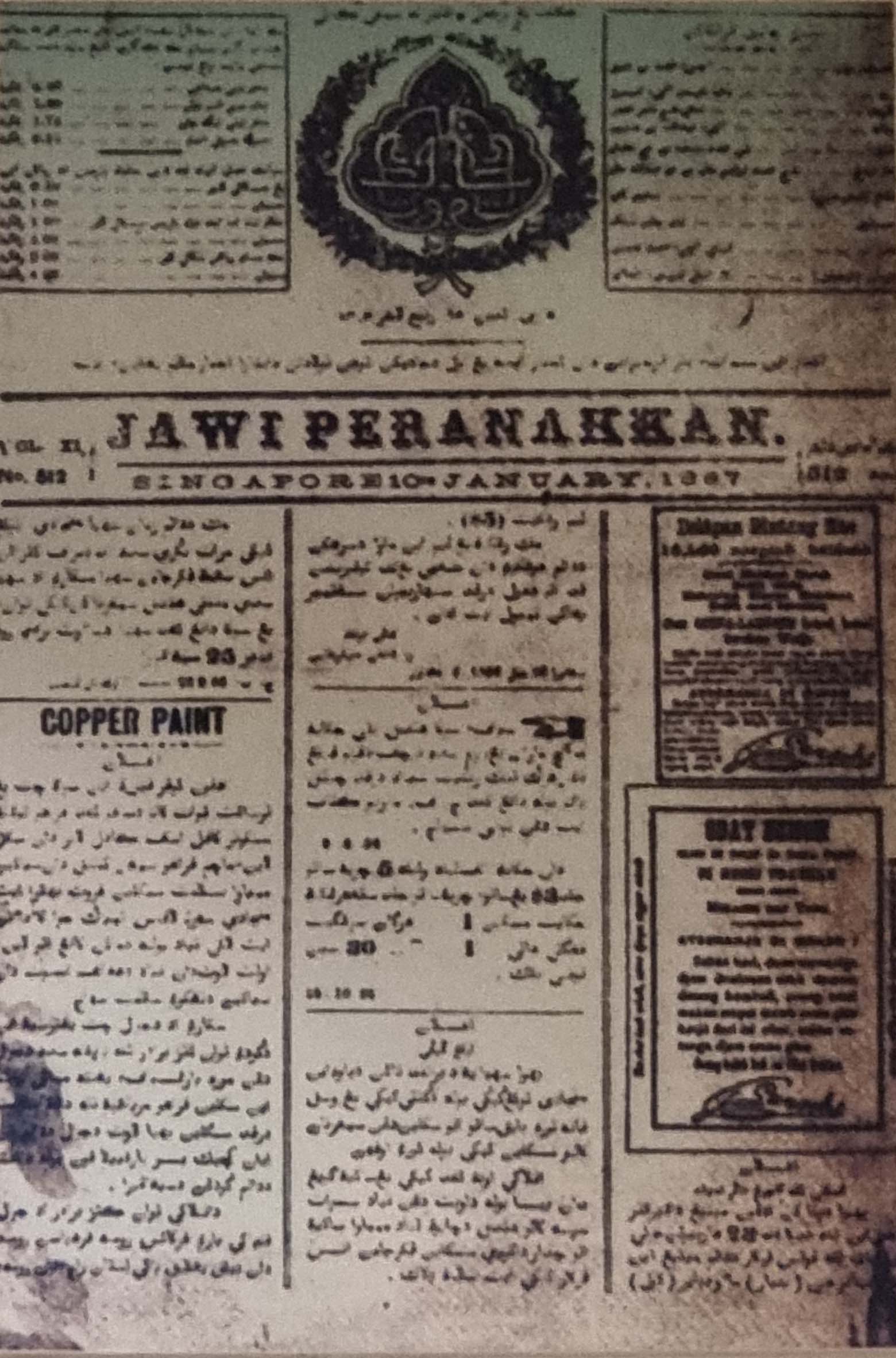
Jawi Peranakan was an elite group during the early decades of Penang’s establishment; they were highly educated and wealthy as well as successful merchants. They also published the first Malay newspaper in Malaysia known as Jawi Peranakkan. In fact, it is reported that Malay journalism history started in 1876 with the publication of the Jawi Peranakkan newspaper in Singapore. The newspaper was founded by Muhammad Said Dada Muhyiddin, who was of Jawi Peranakan descent. When he passed away in 1888, the management together with the printing press passed to his widow. However, the newspaper eventually ceased publication in 1895. During the time when the weekly newspaper was still in print, it was published every Monday and initially sold for 30 cents per copy. It was written in Jawi, covering local and foreign news. Jawi is derived from the Arabic script and it was used widely by the Malays before the Rumi (Romanized) alphabet was introduced.
Image of the front page of a Jawi Peranakkan newspaper at Gallery D, Muzium Negara. Note that the newspaper is spelled with double ‘k’.
In conclusion, the Jawi Peranakan in Penang is a unique society with a rich culture and heritage that reflect the vast diversity of ethnic groups in Malaysia. In fact, the people of Jawi Peranakan are now largely identified as Malay due to the social amalgamation and assimilation with Malay cultures since a long time ago. They have adopted a plethora of Malay cultures such as food, dress, rite of passage ceremonies such as wedding, and they also use the Malay language. The communal strength of this community is that they are a hybrid of Malay and Indian identities, which make them special and different from the rest of Malay community in Penang and Malaysia as a whole.
Jasin, A. (2020, Jan 9). I’m A Malay, Therefore I’m Jawi But I Feel Malaysian. Retrieved July 21, 2021, from Malaysiakini Web site: https://www.malaysiakini.com/news/506475
Yusoff, O., & Mohamed, N. (2010). Daripada Jawi Peranakan Kepada Melayu: Tinjauan Terhadap Komuniti Jawi Peranakan Di Pulau Pinang Pada Abad Ke-21. SARI: Jurnal Alam dan Tamadun Melayu, 28(2), 63-82.
Yusoff, O., Mohamed, N., Ramli, A., & Ahmad, Z. (2013). Pemikiran dan Falsafah Adat Resam Perkahwinan Jawi Peranakan Pulau Pinang. Journal of Human Development and Communication, 2, 141-159. Zulkiffli, Z. (2015, April 24). Jawi Peranakan Bukan Mamak. Retrieved July 19, 2021, from myMetro Web site: https://api.hmetro.com.my/node/46073
In this Series
Click HERE for a list of articles in the A-Z at ‘Muzium Negara’ series.
Sarawak, Land of Hornbills, is the largest state in Malaysia. It is located on the northwest coast of Borneo Island. Sarawak is a stunning state with unique and diverse cultures, along with wild and ravishing rainforests. Before 1841, the Brunei Sultanate reigned over the state, before the Brooke era from 1841 to 1941 and before the Japanese Occupation from 1941 to 1945. After the Japanese sought peace in August 1945, Sarawak was placed under British Military Rule until April 1946. On July 1, 1946, Sarawak became a British Crown Colony before it eventually joined Malaysia in 1963.
Map of Borneo: This island of Borneo that consists of three different countries, Malaysia, Indonesia and Brunei. Image source: Peter Fitzgerald, minor amendments by Joelf, CC BY-SA 4.0, via Wikimedia Commons https://commons.wikimedia.org/wiki/File:Borneo_map.png
Sarawak is a diverse state, consisting of 26 different ethnic groups including Malay, Chinese, and Iban, Bidayuh, Melanau and other indigenous tribes collectively known as Orang Ulu. Each group has its own language and unique culture. Generally, the indigenous peoples of Sarawak continue to show reverence towards their rainforests even until today. Despite the prolonged exposure to the outside world, the indigenous peoples of Sarawak retain their ancestors’ culture and traditions.
Formerly known as Sea Dayaks, the Iban is one of the most populous ethnic groups in Sarawak. They were known as Sea Dayaks by the British because they were often seen patrolling the sea to help Malays fight against pirates. Furthermore, the ancestors of Iban Sarawak are believed to have come from the Kapuas River region in western Kalimantan; their move into Sarawak was to search for new swidden land and to expand their territories. The earliest Iban migrations to the thinly populated Sarawak can be categorized as an establishment of pioneer settlements along the tributaries of the Batang Lupar and Saribas rivers. The migration during that time is the beginning of the first major movement, which took about sixteenth generations, approximately during the middle of the sixteenth century. Since then, the Iban gradually travelled northward and eastward through the Rejang Valley; today, they are present in every district and division of Sarawak, be it in the countryside or urban areas.
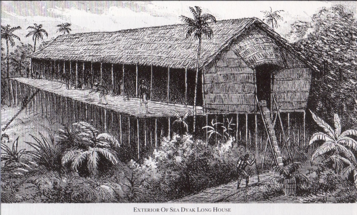
The Iban have a special and unique residence namely the longhouse where the villagers live under one roof. Back then, most the Iban longhouses were situated by the river as it was their main mode of transportation. In addition, there are variations of longhouse designs between different ethnic groups However, the Iban village would normally have only one longhouse, which is in straight-line with a rectangular shape, built using heavy hardwood posts and beam structures. The floors and walls are constructed using bamboos, sometimes with wood barks and palm thatch roofs. It is almost conceptually similar to that of terrace row houses, with each compartment or home separated by walls and sharing a common street. Each family has its own personal compartment known as bilek, which is equipped with sleeping and cooking areas. The cooking area is the area where the ‘ladies of the house’ clean and cook, as well as socialize with other women. Simply said, it is an area only for the females in the house.
Additionally, the covered corridor known as ruai and located at the front of the bilek, running along the longhouse, can be considered as the men’s domain. The ruai is an area where community meetings, major ritual performances and wedding receptions are held, apart from it being a hall to entertain guests. Here, men also gather for daily chores such as mending fishnets and traps. In essence, while the bilek is a private and domestic space for the family, ruai is a public space dedicated for the longhouse members and guests; it is on the upper floor of the longhouse known as sadau in Iban. The distance between the ground and the base of the house can be several feet. It is assumed that the style of the house, gathered in one common structure, is convenient in order to protect the villagers. Furthermore, its high structure helps prevent effects of flooding and provides protection from wild beasts. In essence, the longhouse structures were developed as a defensive measure to protect the villagers from tribal ambushes, particularly during the old headhunting days, considering the longhouse is difficult to access, especially as the ladders were removed at night as a security measure.
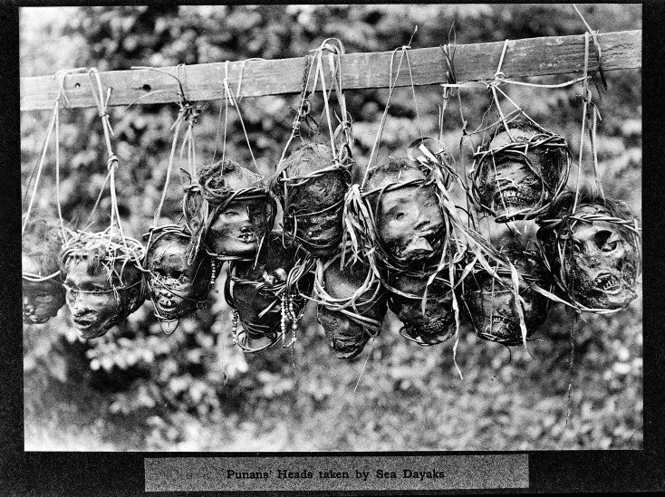
The ancient Iban are well known as fearless and brave warriors, very determined in securing desirable land for swidden agriculture, They will fight enemies or other tribes that intercept their movement or during their mission in extending their lands. The way they fight is different from other Borneans since they are fearless when it comes to displaying their bravery and full-frontal attacks. They also showcase their strength through headhunting or ngayau. It was a custom of Iban warriors to cut off the heads of their enemies after their battles, which were brought back to the longhouse. During the time when ngayau was still practised, it was considered as the symbol of bravery and heroism as well as used to determine an individual’s social status or social rank in the tribe. It is believed that ngayau started when their lands were intruded upon by other tribes and because of the arrival of outsiders that occupied lands belonging to them.
Typically, the Iban warrior possessing strong skills and effective techniques in battles will be the one appointed as the tribal chief, praised by others, as well as feared among the tribes. This explains why, the Sarawak Iban are famously known as warriors and have been called as ‘the wickedest head-hunters’ even though their headhunting days ended a very long time ago. Additionally, because of their bravery, the Iban were recruited as part of the military known as Sarawak Rangers. The Sarawak Rangers played a vital role in fighting the Japanese during Japanese Occupation (1941-1945) and against the communists during Malayan Emergency (1948-1960).
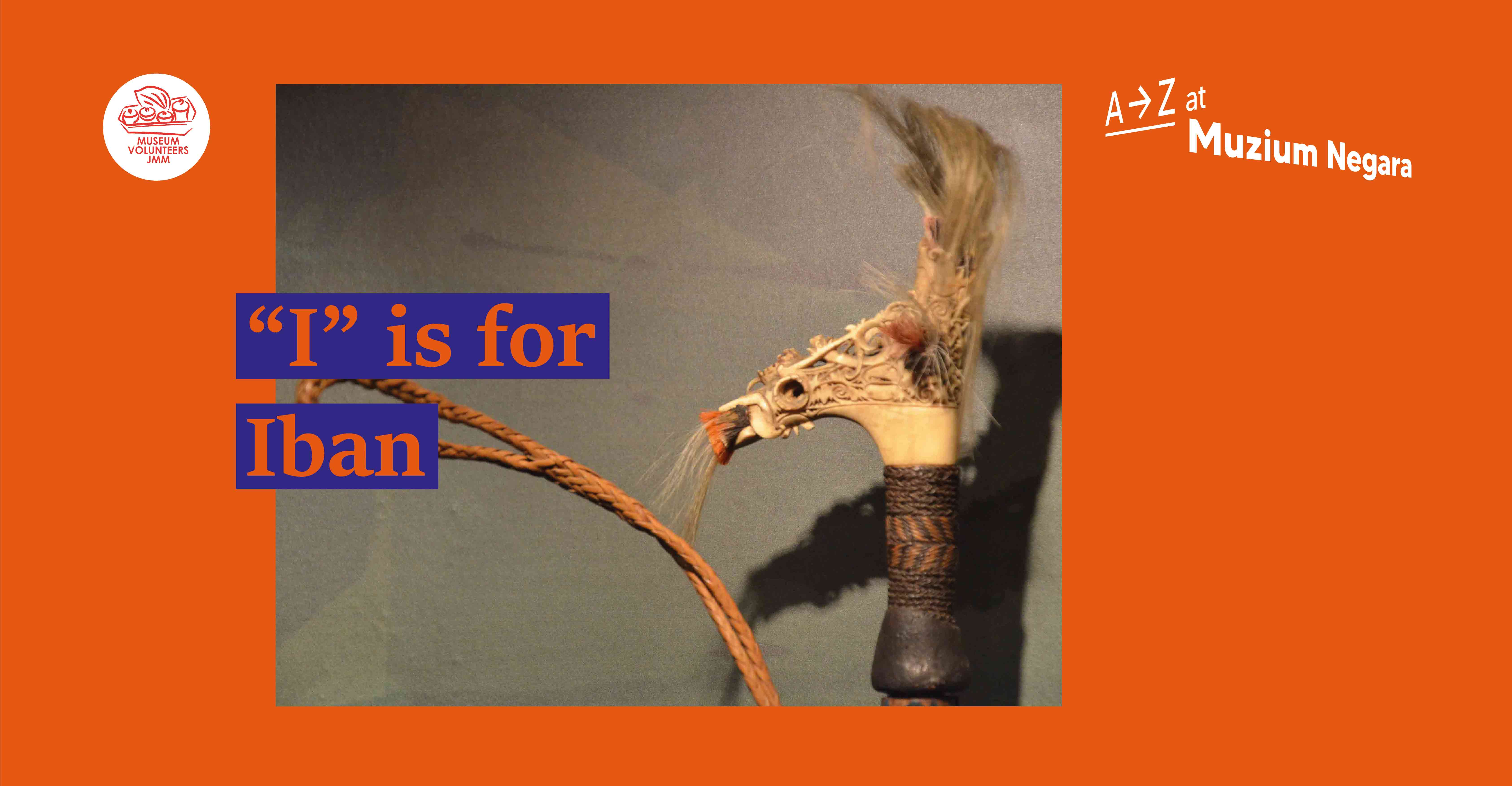
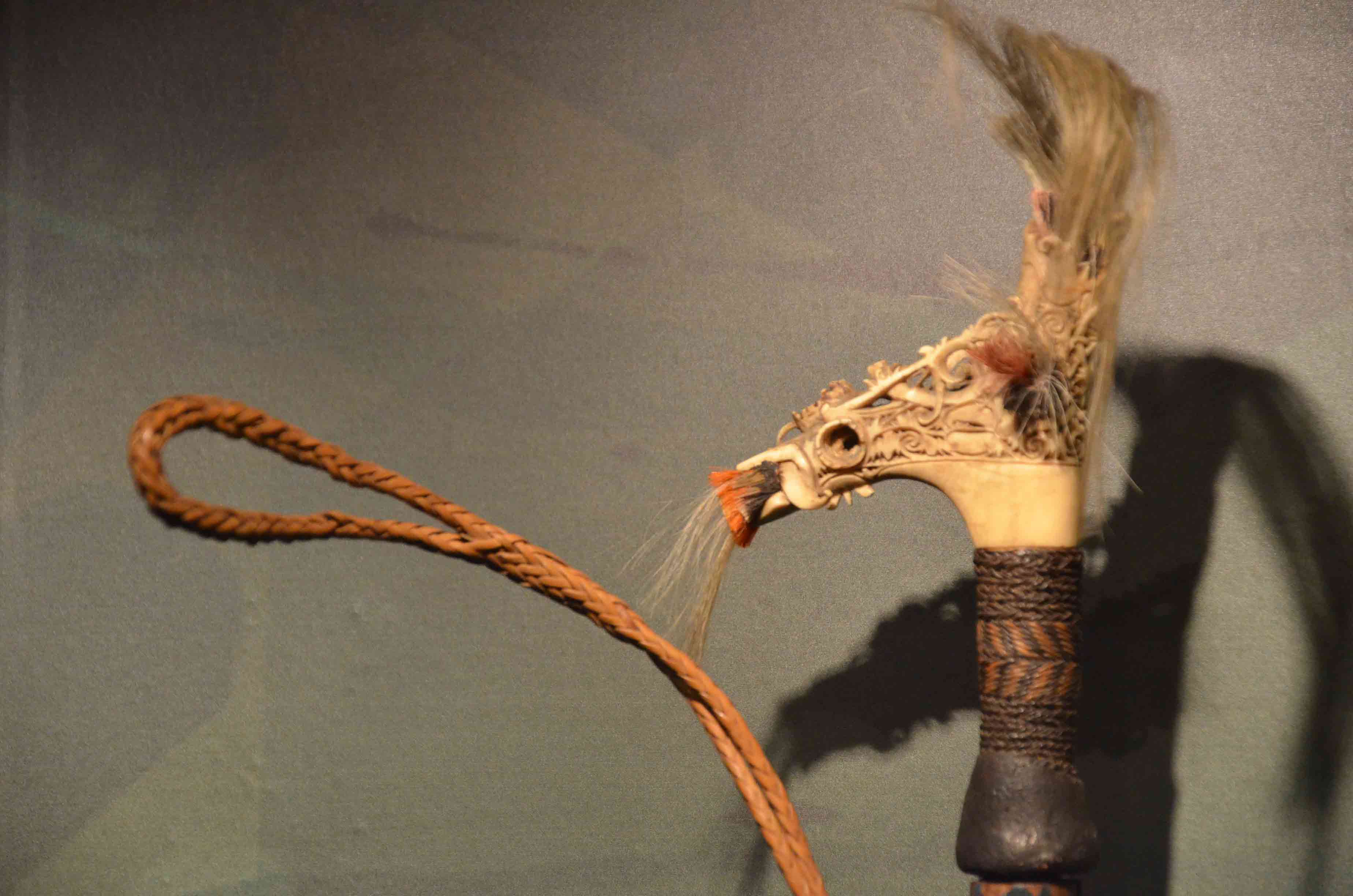
The sword used by the Iban during headhunting is known as Parang Ilang. The sword represents the symbol of courage and their excellent fighting skills. Most Iban men would usually own a Parang Ilang as it is an essential weapon used for hunting and protecting their family from enemies. Apart from that, the same sword would also be used for rituals and traditional medications, which include a cure for shingles (kayap). In the past, the hilt of the sword would be decorated with human hairs obtained through ngayau. Iban hold a strong belief that if the warrior passed away and owned the Parang Ilang, then the sword shall be inherited by the heir of his family because as it is believed that the warrior’s soul remains with the sword despite his demise. Therefore, it shall not be easily passed onto other people except their legal heir. In essence, Parang Ilang is the traditional weapon of Iban where the sword remains important in the Iban community, making it a part of tangible heritage that is still being preserved among the Iban cultures until today.
A beautifully carved hilt of a parang ilang from Muzium Negara’s collection. Image credit: Maganjeet Kaur
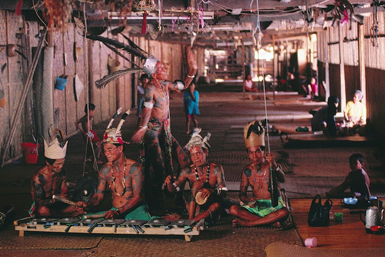
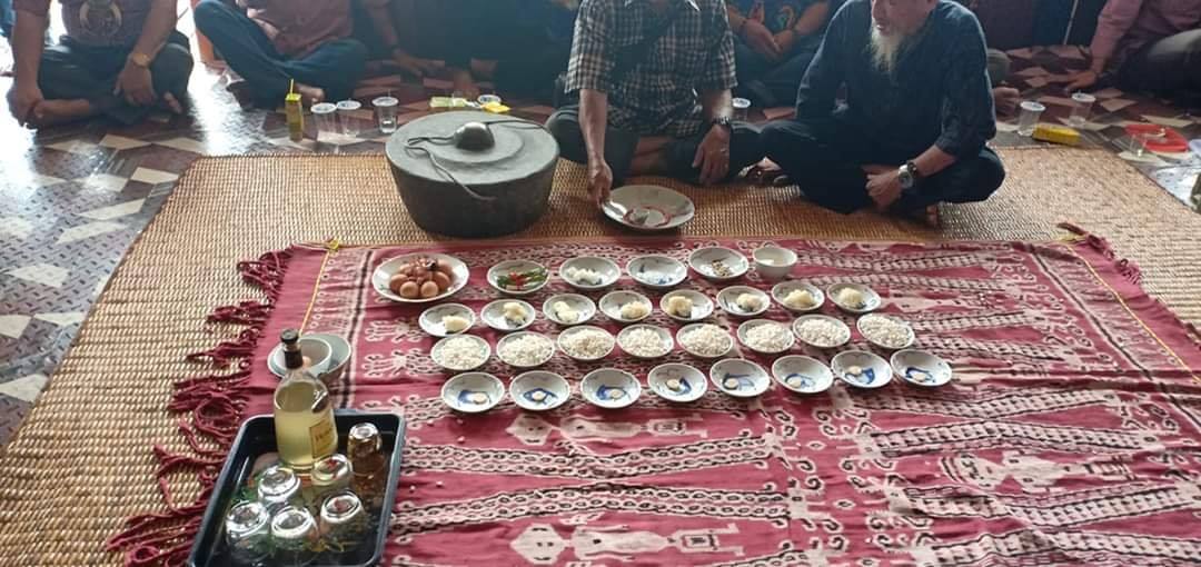
Like most of the indigenous people, the Iban are traditionally animists, who believe that everything, be it animate or inanimate, has a spirit that can influence the events in their life. One of the many rituals still being practiced by the Iban is Miring, an offering ceremony aimed to honour the gods, spirits and souls of dead ancestors. This belief seeks their ancestors’ help and blessing before any important event is held. According to the old faith of the Iban, it is believed that if the supernatural is not fed, they will not obtain the blessing, which will cause disasters and misfortunes. The miring ritual is still practiced whenever the Iban celebrate their annual harvest festival known as Gawai Dayak, in order to thank the rice spirits that have blessed their community with good harvests. Gawai Dayak is a major festival not only for the Iban, but also for other indigenous people in Sarawak.
Animistic rituals have been practiced by the indigenous people for a long time but over time, some communities have embraced other religions and changed their lifestyles; majority have embraced Christianity. Nowadays, the Iban have successfully adapted to the modernisation and globalization era, their longhouses are completely equipped with modern facilities and essential necessities such as electricity and water supplies, the Internet, telephone line and roads. Most of the younger generation can also be found living in the urban areas, yet they always return to their hometown especially during the festive seasons to visit families. Furthermore, they also live peacefully with other tribes and races such as Bidayuh, Malays and Chinese. Although, the Iban today have been exposed to modernization and globalisation, yet they have impressively managed to preserve their ancestors’ customs, ritual and traditional beliefs including their traditional costumes, the Ngajat dance, Pua Kumbu, Parang Ilang, traditional foods, the longhouse, Gawai Dayak festival and many more.
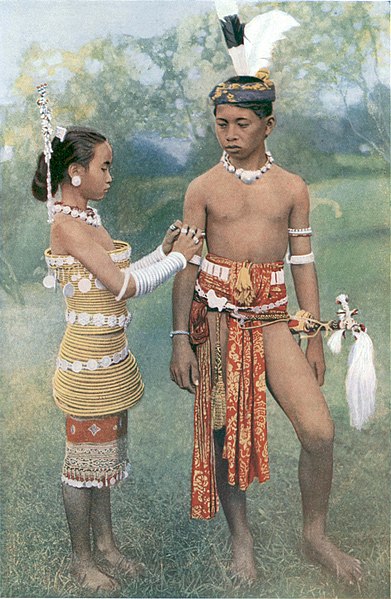
The boy is in traditional costume accessorised with headgear and Parang Ilang. The girl is wearing the rawai, a corset of rattan hoops secured by small brass rings stiffened around the torso, with sugu tinggi (silver headgear) and tumpa (bangles). Image credit: Charles Hose, Public domain, via Wikimedia Commons https://commons.wikimedia.org/wiki/File:Young_Ibans,_or_Sea_Dayaks.jpg
Asri, A., & Tugang, N. (2019). Arts and Aesthetic Values Towards Parang Ilang in the Culture of the Iban. The International Journal of Inovative Design, Creativity and Social Sciences, 3(1), 1-8. Retrieved July 14, 2021, from http://ir.unimas.my/id/eprint/28700
Jelani, J., & Noor Muhammad, S. (2018). The Influence of Animism on the Customs and Culture of the Iban Community. International Journal of Academic Research in Business and Social Sciences, 8(8), 763-774. doi:10.6007/IJARBSS/v8-i8/4631
Kiyai@Keai, G., & Tugang, N. (2020). Artifak Budaya Masyarakat Iban: Warisan Pusaka. Jurnal Kinabalu, 26(1), 59-71.
Mahayuddin, S., Wan Zaharuddin, W., Harun, S., & Ismail, B. (2017). Assessment of Building Typology and Construction Method of Traditional Longhouse. Procedia Engineering, 180, 1015-1023. doi:10.1016/j.proeng.2017.04.261
Mohanlall, P. (2002). Green Malaysia: Rainforest Encounters. Kuala Lumpur: Malaysian Timber Council.
Noria T., Anna, D., Yow, C.L., Hashim, A., Adilawati, A., & Bibiana, S. (2018). The Iban Folk Belief. International Journal of Academic Research in Business & Social Sciences, 8(14), 100-107. doi:10.6007/IJARBSS/v8-i14/5031
Osup, C. (2017). Social Relation Between Gender (Sexes) In The Iban Longhouse Community. International Journal for Studies on Children Women, Elderly and Disabled, 2, 2-31. Retrieved July 15, 2021, from https://www.ijcwed.com/wp-content/uploads/2017/06/IJCWED2_36.pdf
Padoch, C. (1982). Migration and Its Alternative Among the Iban Sarawak. Netherlands: The Hague : Martinus Nijhoff.
Radzi, H., & David, P. (2012). Unsur Eufemisme Dan Perumpamaan Dalam Teks Hikyat Iban. Jurnal Linguistik, 16, 75-87.
SODA, R. (2001). Rural-Urban Migration of the Iban of Sarawak and Changes in Long-house Communities. Geographical Review of Japan, Series B. 74(1), 92-112. doi:10.4157/grj1984b.74.92
In this Series
Click HERE for a list of articles in the A-Z at ‘Muzium Negara’ series.