by Eric Lim
Introduction
Sungai Linggi is one of the major rivers in the state of Negeri Sembilan. The river originates near the hilly purlieu of Pantai, just outside of the capital, Seremban, and it follows a southwestern path across the state to the river mouth in Melaka, an axial length of about 83 km. The name ‘Linggi’ is derived from a Bugis word, which means ‘the stem or bow of a ship’. Pengkalan Kempas and Kuala Linggi are both located along Sungai Linggi – the former is located near the confluence with Sungai Rembau while the latter is at the estuary where the river empties into the Straits of Malacca.
History

As far back as the 14th century CE, Sungai Linggi was the main route in and out of Sungai Ujong (Seremban today), flowing from the interior to the coast. It was the only means of entry and circulation for traders. It was said that Parameswara used this waterway to reach Sungai Ujong prior to the founding of Melaka. Sungai Ujong later came under the control of the Melaka Sultanate. The Minangkabau and Bugis who were the earliest settlers in Negeri Sembilan used it to transport jungle produce and tin to Melaka when it became an entrepot. In a plot to get back in Sultan Mahmud Shah’s favour, Hang Tuah made his voyage to Pahang and succeeded to ‘charm’ the beautiful Tun Teja with some help from the ‘magical love potion’ which made her agree to accompany Hang Tuah on his boat to Melaka. However, Tun Teja found out later that she was betrayed by Hang Tuah. She eventually agreed to marry Sultan Mahmud Shah. For the mission accomplished, Hang Tuah was conferred the title ‘Laksamana’ (admiral).

When the Johor Sultanate started to lose its grip on Negeri Sembilan, the Bugis from Riau under Daeng Kemboja, made inroads into the state and settled at Linggi. In 1756, the Bugis laid siege to Melaka, which was then ruled by the Dutch. In retaliation, Dutch reinforcement attacked the Bugis’s base the following year. The Bugis then decided to call a truce and both warring parties agreed to build a fort at the estuary of Sungai Linggi (for more information, check section on Kuala Linggi below). After a long period of peace, in 1784, the Bugis under Sultan Ibrahim of Selangor mounted another attack on Dutch Melaka. He sailed up Sungai Linggi to Rembau and rounded up Minangkabaus fighters from Rembau and Pedas for the attack.
After the Dutch left Melaka, Negeri Sembilan was divided into two camps – Dato Kelana and Dato Bandar –that fought to control Sungai Linggi, which had become the major trade highway. The Chinese started mining around Rasah in 1828 but left the tin mines to move to Selangor because of trouble with the Malays. They returned in 1830 and by 1874, there were 15,000 Chinese in Sungai Ujong; by then, it was a major tin mining area in the country.
On 21 April 1874, Dato Kelana and Dato Muda Linggi signed an agreement with the British seeking their protection and recognition of Dato Kelana as the ruler of Sungai Ujong. In the process, Dato Bandar surrendered to the British and he was sent to exile in Singapore. After the ouster, the opposing camp was now led by Yamtuan Antah of Seri Menanti. They started a move to drive the British out of Sungai Ujong and this paved the start of the Sungai Ujong War in December 1875. By the 22nd of December, British forces captured the stockades at Bukit Putus and Ulu Bandol and reached Yamtuan Antah’s stronghold at Seri Menanti where they burned his palace, Istana Pulih, to the ground.

Five years into the British Residential system in Sungai Ujong, Isabella Lucy Bird, Victorian explorer, naturalist and writer (international traveller and adventure blogger by today’s classification) visited Sungai Ujong via Sungai Linggi. In her book ‘The Golden Chersonese and the way thither’ published in 1883, she wrote that she visited the tomb of a ‘great prophet’ who was slain in ascending the Linggi (for more information, check section on Pengkalan Kempas below). She then visited ‘Serambang’ (Seremban) and she was shown around the town by the host, British Resident Captain Murray. She also stayed at a sanatorium located three miles away in what the Resident called ‘Plantation Hill’. Isabella also wrote of her interest to stay longer in order for her to make acquaintance with a colony of ants!
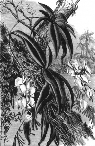

(Left) – Greater moth orchid / (Right) – Elk horn fern – The Golden Chersonese And The Way Thither. Photo source – Wikimedia Commons
Places of Interest

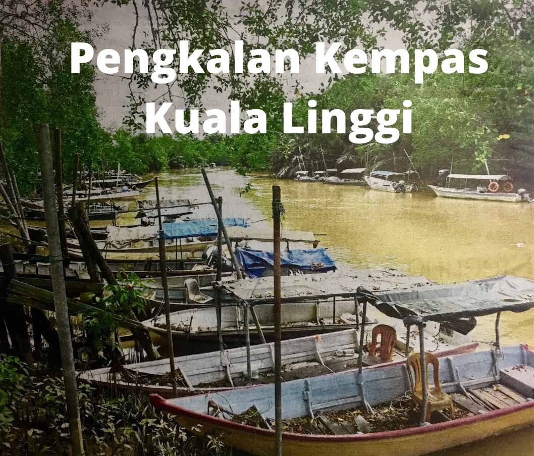
The distance between Port Dickson town and Pengkalan Kempas is about 33 km via Federal Route 5. Pengkalan Kempas [1] is a one-street town and just a stone’s throw from Sungai Linggi. The first attraction of the town is the jetty (see first photo), which is located just before the town. Sungai Linggi is well known for giant freshwater prawns. There are plenty of boats available for rental to catch prawns. Besides that, visitors can take eco tours exploring the river, mangrove forest and catch a glimpse of saltwater crocodiles. It is reported that the population has reached 3,000. Isabella also encountered a crocodile, which she called an alligator on her cruise up the river (incidentally, a crocodile is larger than an alligator). In the olden days, this jetty was a bustling place. Tax was collected from traders and it was a key landing point for Chinese settlers predominantly from the Fujian Province. The town folks are very proud of this history that they had erected a sign to proclaim the landing site.

Directly opposite the jetty is the Police Station, which was established in 1920. It also served as a tax collection centre. The town is flanked on either side by pre-war shophouses but most of the shops are closed. The town used to be the pit stop for motorists en-route to Melaka. At the end of the street is SJK (C) Yik Hwa, a Chinese primary school that was opened on 15 November 1923. In 2018, it had an enrolment of only 49 pupils. Further up, located on a hillock is the Chinese Methodist Church, built in 1928. The worship service is on every Sunday at 4.00 pm.
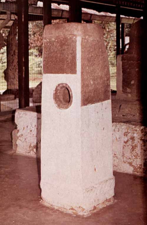
Across the road from the church is the main drawcard of the town, the Pengkalan Kempas Historical Complex. When Isabella made the visit in 1880, it was known as Keramat Sungai Udang (prawn river shrine). Today, the complex consists of the tomb, a four-sided inscription tombstone with a cylindrical shaped hole at the centre and a number of ancient stones/megaliths.
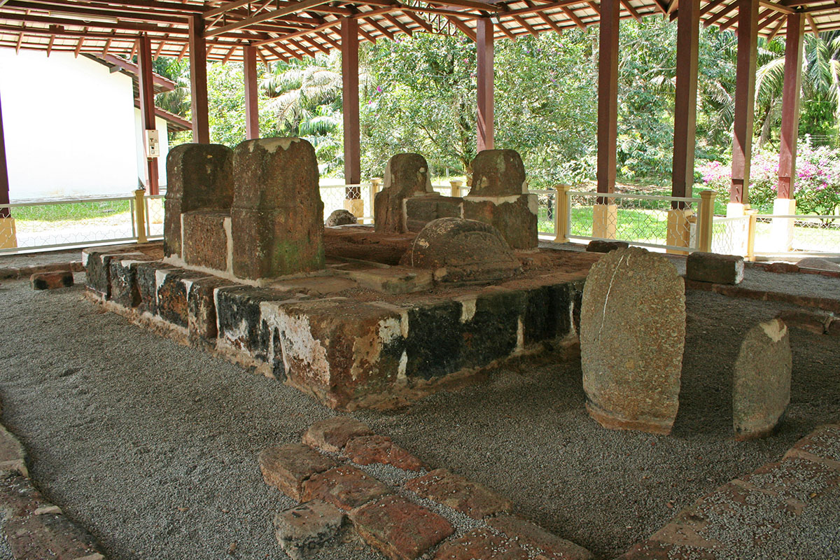
According to the epitaph, the tomb is the final resting place of a saint, Sheikh Ahmad Majnun (also spelt as Ahmat Majanu), and it is dated to the 872 Hijrah era, corresponding to the year 1467/1468. It is also written that the ‘saint’ would by no means have been a holy man but on the contrary a traitor who was executed after an unsuccessful attempt at the life of Sultan Mansur Shah. Many scholars had come to study the tomb and offered their views. However, many questions remain unanswered until today. Who was Sheikh Ahmad Majnun? Was he a saint or a traitor? If he was a traitor, why was he commemorated with a true Muslim burial? Incidentally, the word ‘Majnun’ means ‘crazy’ in Arabic. As to the hole at the centre of the tombstone, many believe it is an olden day ‘lie detector’. Anyone who dares to take the challenge, do it at your own peril. Based on the date of this tomb, it is one of the oldest Muslim tombs in the country.
The megaliths found at the site are menhirs (freestanding stones) believed to be from the 2nd/3rd century CE; the locals called them ‘batu hidup’ or living stone. The most well known is the cluster of three erected inscription stones which are nicknamed after their distinctive shapes i.e rudder, spoon and sword. The rudder shaped stone has inscriptions of a horse, tiger, barking deer (known locally as kijang) and probably an elephant’s trunk. Interestingly, the sword stone has the Arabic word ‘Allah’ that sticks out a mile. This leads to more baffling mystery as the stone predates Islam. However, J.G. de Casparis concluded that the sword stone post-dates the introduction of Islam into the Malay Peninsula and probably only dates back to the middle of the fifteenth century.
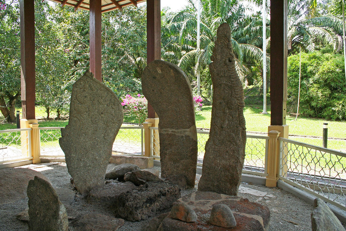
(Left) – Inscription tombstone / Photo source : AHMAT MAJANU’S TOMBSTONE AT PENGKALAN KEMPAS AND ITS KAWI INSCRIPTION(Right) – Cluster of three erected inscription stones, namely rudder, spoon and sword respectively / Photo source : Pengkalan Kempas
Megaliths in the Malay Peninsula are mainly found within the border of Melaka and Negeri Sembilan i.e in Alor Gajah district in Melaka and in Kuala Pilah, Rembau and Tampin districts in Negeri Sembilan. These upright stones are around 2 to 8 feet in height and arranged either in a cluster of one large menhir surrounded by smaller stones or in pairs and aligned side by side with one stone larger than the other. These stones are erected on earth mounds. Excavation of the megalithic site at Kampong Ipoh in Tampin, Negeri Sembilan by the Museums Department in 1981, found no skeletal remains in the megalithic area. The excavation proved that the megalithic groupings in Malaysia were not the sites of historic or prehistoric burial as believed by the local people. Research into megaliths in our country is rather scarce. Until today, the purpose and age of the megaliths remain a mystery. Some of the megaliths from the Tampin excavation are on display at the grounds of the National Museum in Kuala Lumpur. Another place to see these ancient stones is Laman Megalit (Megalith Park) inside Taman Putra Perdana in Putrajaya. The park which was completed in 2003 has over eighty erected megaliths and these stones were discovered by Petronas during work to lay a gas pipeline at Kampung Gelanggang in Negri Sembilan in 1989. Prior, the stones were displayed at the Petronas Megalith Garden located between Dayabumi and Kuala Lumpur Railway Station in the city.

The next destination is Kuala Linggi [2] in Melaka, which is about 15 km from Pengkalan Kempas using Federal Route 5 heading to Port Dickson. Upon reaching Kampung Sungai Raya, exit to join N143 Jalan Pasir Panjang-Kuala Linggi. In my article about Lukut, I have mentioned Raja Sulaiman of Sungai Raya who had wanted to be liberated from the clutches of Raja Bot at Lukut but he failed to make a breakthrough. At the 12 km point, the Kuala Linggi Bridge would be in full view. This bridge was officially opened on 10 July 1990 by Tun Dr Mahathir when he was the fourth Prime Minister of Malaysia. The bridge serves as a border crossing between Negeri Sembilan and Melaka and it is currently a popular spot for fishing. A short distance from the bridge and located on top of a hill at the mouth of Sungai Linggi is Kota Bukit Supai / Sepoy Hill Fort. The word ‘supai’ may not be Malay but a Persian or Hindi word, which has the same meaning as ‘sipahi’, which means ‘sepoy’ or an infantry soldier. The sepoy guarding this fort were trained to use weapons, initially matchlock muskets and later flintlock, which was brought to the East by the Dutch. The Dutch name for the flintlock weapon was ‘snaphaan’, passed on to Malay as ‘senapang’ (rifle in English).
As mentioned earlier, the fort was built jointly by the Bugis and Dutch after the restoration of friendly relations and a peace treaty was signed on 1 January 1758 at the completion of the fort. The terms of the treaty were heavily in favour of the Dutch – first, they had full control of the fort, and second, they controlled all ship movements on Sungai Linggi and collected taxes from ships transporting tin quarried in the interior of Sungai Linggi and Sungai Rembau. The fort is rectangular, measuring 167 feet by 150 feet, fortified with bastions at every corner and the two entrances, landward and seaward. The walls were about eight feet high and a moat surrounded the fort. The Dutch named the fort, Fort Filipina, after the daughter of Jacob Mosel, the Governor General of the Dutch United East India Company (Dutch name, Vereenigde Oost Indische Compagnie, in short VOC) at that time. About a year later, the Dutch abandoned the fort.

Kota Bukit Supai / Sepoy Hill Fort / Fort FilipinaPhoto source : Halaman Utama Portal Rasmi Majlis Perbandaran Alor Gajah (MPAG)
Between 1974 and 1975, the Museums Department initiated some conservation works on the remains of the fort. Buildings that were built within the fort and the seaward passageway that connected the fort and the landing stage at the beach had disappeared. The fort was later gazetted as a historical monument under the Antiquities Act 1976. As one of the ways to attract visitors to the site, the Alor Gajah Town Council have built a seafood restaurant on stilts and linked the eatery to the fort by a walkway. One wonders what would be the probability that the path of this walkway, the same as the original seaward passageway that had disappeared?

T.A.G Marine Sdn Bhd (TMSB) is a local company involved in the shipping and maritime industry. They are licensed port operator/service provider and operated the Kuala Linggi International Port (KLIP) when it was gazetted in July 2006. The port is situated near the river mouth of Sungai Linggi. Since then, it has been providing ship-to-ship cargo transfer services and it has attracted a host of large carriers and ships. One of its major successes was Gazprom’s first ship-to-ship transfer of LNG cargo on 6 December 2014. In 2019, the company announced a RM15 billion KLIP expansion project. The land reclamation is expected to be completed in 48 months. This raised concern by the local communities for the protection and preservation of the environment and wildlife. In a press report on 13 March 2021, the Melaka Menteri Besar has said that it will ensure that the environmental impact assessment (EIA) will be carried out prior to the construction of the KLIP.

Unknown to many, the Linggi-Rembau estuary is blessed with a firefly colony. The Negeri Sembilan Tourism started to promote it as an attraction in 2008. Since then the Pengkalan Nelayan Sungai Timun [3] jetty in Rembau district has seen an increasing number of both local and foreign tourists. An added feature of the Sungai Timun fireflies is the combination of both the species that practice synchronous flashing and the non-synchronous flashing species. The former is known as Pteroptyx tener and the latter are Pteroptyx assymmetria and Pteroptyx malaccae. Based on studies done, there are 2200 identified types worldwide and in Malaysia, there are about 100 identified types. The local name for fireflies is ‘kelip kelip’, which means to flicker. Its life cycle consists of eggs, larvae, pupae and adults. It takes about a year for it to grow to adult size of 1-2 cm and adults only live for about two months. Fireflies in the mangrove forest congregate on the Berembang trees (Sonneratia caseolaris/mangrove apple) as a source of food and protection from the sun. Other mangrove trees that support the population of fireflies are nipa palms, nibong palms and ferns. Incidentally, July is the month where World Firefly Day is celebrated and this year, it was on 3-4 July. The theme for this year’s celebration is ‘Watch us, don’t catch us!’ which is to promote firefly tourism. It is hoped that the mangrove forest at Sungai Linggi and Sungai Rembau will be protected and preserved so that the giant freshwater prawns, saltwater crocodiles, fireflies, mangrove trees and the livelihood of the communities will continue.

Getting There
From Kuala Lumpur city centre, use the North South Highway (E2 South) and exit at Exit 223 Pedas Linggi. After the toll, head to Linggi. At Linggi, join Federal Route 5 to Pengkalan Kempas. From Pengkalan Kempas to Kuala Linggi, use Federal Route 5 and head to Port Dickson. Upon reaching Kampung Sungai Raya, exit to join N143 Jalan Pasir Panjang-Kuala Linggi. To go to Pengkalan Nelayan Sungai Timun from Pengkalan Kempas, join Federal Route 5 and head to Linggi and Lubok Cina. Before Lubok Cina, watch out for the turning to N116 Jalan Sungai Timun. The jetty is further ahead.
In this Series
Please click HERE for a list of articles in the ‘A Very Rough Guide’ series.
References
NEGERI SEMBILAN – PENGKALAN KEMPAS & PASAR NELAYAN TELOK KEMANG
Tun Teja Mausoleum: a story of love, betrayal and war
Previous Post:Perjanjian Sungai Ujung 1874
A Battlefield Tour… – Sabri Zain’s Malayan History Society
The Golden Chersonese And The Way Thither
AHMAT MAJANU’S TOMBSTONE AT PENGKALAN KEMPAS AND ITS KAWI INSCRIPTION
The Excavation of the Megalithic Alignment at Kampong Ipoh, Tampin, Negeri Sembilan. A Note
Megalith Stones at Laman Megalit, Putrajaya.
Notes on the old Cannon found in Malaya, and known to be of Dutch origin – Footnotes 9 and 26
Halaman Utama Portal Rasmi Majlis Perbandaran Alor Gajah (MPAG)
Keeping the firefly magic alive
https://fireflyersinternational.net/world-firefly-day
