Focus Talk: General Percival & The Fall of Malaya by Zafrani Amran

written by Manjeet Dhillon

The surrender of British forces to the Imperial Japanese Army on 15 February 1942 was more than a military defeat, it was a shattering of colonial dominance in Southeast Asia. In his compelling talk, Zafrani Amran explores the calculated strategies, critical oversights, and unforeseen events that led to this seismic event.

Japan’s Rise to Power and Expansionist Ambitions
From the Meiji Restoration in 1868 to the early 20th century, Japan transformed from a feudal society to a formidable industrial power. This modernisation fuelled its ambitions for regional dominance, culminating in its aggressive expansion across Asia. The slogan “Fukoku Kyohei” (Rich Country, Strong Army) guided the nation’s transformation.

By the late 1930s, Japan faced crippling resource shortages due to international embargoes, particularly on oil and rubber. These pressures drove its decision to secure Southeast Asia’s rich resources, making Malaya a critical target.

Key milestones in Japan’s rise include:

EventYearSignificance
Meiji Restoration1868Japan begins its modernisation process.Formation of the Imperial Japanese Army and Navy
Treaty of Ganghwa1876Opening Korea to Japanese influence
First Sino-Japanese War1894-1895Japan defeats China, gaining control of Taiwan and Korea.
Anglo Japanese Alliance1902-1923Japanese forces provided military support as part of this alliance, a role evident during the Singapore Mutiny of 1915.
Russo-Japanese War1904-1905Japan defeats Russia, emerging as a major power in Asia.
Annexation of Korea1910Japan formally annexes Korea.
Invasion of Manchuria1931Japan seizes control of Manchuria.
Second Sino-Japanese War1937-1945Japan invades China. (Marco Polo bridge incident)
Tripartite Pact,September 27, 1940a military alliance between Germany, Italy, and Japan, aimed to deter U.S. intervention in World War II
Occupied French IndochinaJuly 1941To secure its supply lines and further isolate China.
Capture of Lashio and closure of the Burma RoadApril 1942To further isolate China, Japan closed the Burma Road, a key supply route for Western aid. 

Japan’s Road To Conquest
Japan’s prolonged war with China drained its resources. To secure vital supplies and cut off Chinese access to foreign aid, Japan occupied French Indochina, a move facilitated by the Vichy French regime (a pro-German regime).
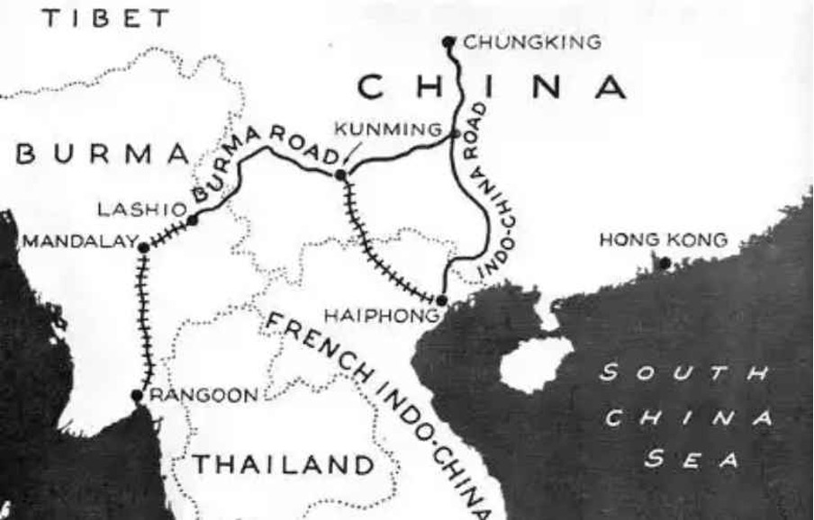
Burma road
Image source: https://www.dangerousroads.org/asia/china/321-burma-road-china.html

Faced with a crippling U.S. oil embargo, Japan sought alternative resources in Southeast Asia, particularly the oil-rich Dutch East Indies. Despite attempts at negotiation, the Dutch, backed by the U.S., refused to meet Japan’s demands. Recognising the intransigence of the Dutch and the urgency of its resource needs, Japan concluded that military force was the only viable option. To secure these resources and neutralise potential threats, Japan launched a bold military campaign. The attack on Pearl Harbor and the invasion of Malaya were crucial steps in this strategy, by neutralising the U.S. Pacific Fleet and capturing key British military bases, Japan aimed to create a defensive perimeter in the Pacific and secure its resource supply lines.

The desire for natural resources, particularly oil, and the pursuit of a “Greater East Asia Co-Prosperity Sphere” propelled Japan towards a fateful confrontation with the Western powers.

Preparation for War: The Malayan Campaign
To prepare for the invasion of Malaya, the Japanese military undertook a series of strategic initiatives:

● Establishing a Research Section: The “Taiwan Army Research Section,” led by Colonel Masataro Tsuji, was established to develop specialised tactics and doctrine for jungle warfare.

● Intensive Training: The Japanese military conducted extensive training exercises in Taiwan and Hainan Island, focusing on beach landings, rapid advances, and combined arms operations in jungle terrain.

● Intelligence Gathering: A network of spies (referred to as a “fifth column), including Major Kunitake, was deployed to gather critical intelligence on Malaya’s terrain, infrastructure, and British defences.
○ Major Kunitake, stationed as an assistant Japanese consul in Singapore, identified over 250 bridges crucial for military operations, enabling the Japanese to pre-plan rapid repair efforts in the event of British sabotage.

● Developing a Comprehensive Guidebook: Colonel Tsuji’s tactical manual, aptly titled “Read This Alone, And The War Can Be Won,” (これだけ読めば戦は勝てる) equipped Japanese troops with jungle warfare expertise.

Book cover: “Read This Alone, And The War Can Be Won”
Image source: https://www.jacar.archives.go.jp/aj/meta/listPhoto?LANG=default&BID=F2014120214353623900&ID=M2014120214353623902&REFCODE=C14110549200

By meticulously planning and preparing for the invasion, the Japanese were able to exploit the weaknesses in British defences and achieve a swift victory.


Singapore Naval Base
The Singapore Naval Base was a monumental engineering feat and a symbol of British naval power in the Far East. Constructed over a period of nearly 15 years, the base was intended to serve as an impregnable fortress, safeguarding British interests in the region.

The decision to establish the base was driven by growing concerns about Japanese expansionism. As Japan emerged as a regional power, the British recognised the need for a strong naval presence in Southeast Asia. The base was strategically located to protect British trade routes and to deter potential aggression from Japan.

The construction of the Singapore Naval Base began in 1923, but progress was interrupted due to political changes in Britain. The Conservative Party, which initially pushed for the construction, was replaced by the Labour Party in 1924, which halted the project due to economic concerns. Work resumed, and after nearly 15 years, the base was officially opened in 1936, featuring state-of-the-art facilities, including the world’s third-largest floating dry dock. The base’s construction was funded in part by local contributions, with the Federated Malay States and the Sultan of Johore (Sultan Ibrahim Ismail) providing significant financial support. In recognition of the Sultan’s generosity, one of the coastal defence batteries was named the Johore Battery. The base was equipped with powerful coastal defences and protected by the Royal Air Force, making it a formidable fortress.

To safeguard the naval base, the British established fixed defences organised into two Fire Commands:

Fire Command:ChangiFaber
Location:Protected the routes leading to the naval base at Seletar.Protected the approaches to Keppel Harbour and the western channel of the Johore Straits.
Armament: Each Fire Command was equipped with:One 15-inch batteryOne 9.2-inch batterySeveral 6-inch batteries

The Japanese devised a two-pronged strategy to circumvent Singapore’s formidable defences. Instead of a direct frontal assault, they opted for a flanking manoeuvre, attacking from the Malayan Peninsula.

A World Awakened
While the attack on Pearl Harbor (December 8, 1941) captured global attention, another battle was unfolding in Malaya. The Battle of Kota Bharu marked the beginning of Japan’s rapid advance, exploiting British vulnerabilities with surgical precision.

On the night of December 4th, the Japanese Imperial Army had set sail from Samah Harbour in Hainan Island, their destination: the Malayan Peninsula. Meanwhile, in Singapore, a sense of security prevailed. The arrival of the powerful Royal Navy battleships, Prince of Wales and Repulse, had bolstered British confidence. These formidable warships were seen as an impenetrable shield against any potential threat.

However, the Japanese had a different plan. On December 6th, Royal Australian Air Force (RAAF) Hudson aircraft spotted the Japanese convoy stealthily manoeuvring south of Cape Cambodia. The British were alerted, but the dense monsoon clouds provided the invading force with a veil of concealment. Operation Matador was considered. This plan involved a preemptive strike into southern Thailand to disrupt Japanese landing plans. However, the British Minister in Bangkok, Joseph Crofty, strongly advised against this course of action, fearing it would provoke a wider conflict. Operation Matador was ultimately cancelled.

The following day, December 7th, the Japanese fleet appeared on the radar screens, 110 miles north of Kota Bharu. The British, caught off guard, scrambled to respond. But the thick, impenetrable fog provided the Japanese with a crucial advantage, allowing them to close in undetected. As the fog lifted, the full scale of the Japanese invasion became apparent. The British, despite their valiant efforts, were ill-prepared to counter the swift and decisive Japanese advance.

The Battle of Kota Bharu
A lone soldier, silhouetted stark against the lightning sky, pointed a trembling hand out to sea. There, riding low in the water, a dark armada materialised from the mist. Japanese warships, led by the ominous Awajisan Maru, were disgorging a terrifying wave of soldiers into landing craft.

The Awazisan Maru, also known as Awajisan Maru or Awagisan Maru Image source: https://muhammadismailibrahim.wordpress.com/2011/12/08/december-8-1941-the-battle-of-kuala-pak-amat/

The deafening roar of Japanese bombers pounded the airfields at Kota Bharu, Machang, and Gong Kedak. Explosions rocked the nearby airfield, the once-proud defenders of Kota Bharu were now a scattering of panicked men, their dreams of a valiant stand shattered by the overwhelming force of the enemy. Meanwhile, the Japanese naval escort, facing heavy losses from RAAF air attacks, considered withdrawing. However, Major General Takumi, determined to secure the beachhead, overruled the decision.

With air superiority lost and the ground defences crumbling, Brigadier Key ordered a retreat to the southern outskirts of Kota Bharu. The Japanese, under the cover of darkness, launched a final assault on the airfield, capturing it by midnight. The Dogra Regiment, though outnumbered and outgunned, fought with courage and determination. Lieutenant Close, led his men in a desperate last stand, but the relentless Japanese onslaught proved too much to bear. The fall of Kota Bharu marked the beginning of a long and painful retreat for the British forces in Malaya, a defeat that would reverberate through the annals of history.

Lone Bomber
While the Japanese 5th Division stormed the beaches of southern Thailand, another drama unfolded on the other side of the Malay Peninsula. At the battered Butterworth airfield, a lone figure emerged: Squadron Leader Arthur Stewart King Scarf. A pilot of extraordinary courage, he was the last hope for the beleaguered British forces.

As the Japanese air force rained destruction upon the airfield, Scarf defied the odds. In his battered Bristol Blenheim, he took to the skies, his mission was audacious: to strike at the heart of the Japanese invasion, targeting the enemy airfield at Singgora.

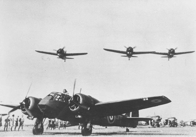
Blenheim of 62 Squadron and Brewster Buffalo fighters in Malaya 1941
(© RAF Museum X004- 7598/042/018)

With enemy fighters hot on his tail, Scarf pressed on, his plane a mere speck against the vast expanse of the sky. Undeterred, he unleashed a torrent of bombs, sowing chaos among the Japanese forces. But the cost was high, his plane, riddled with bullet holes, began to falter.

Wounded and weakened, Scarf struggled to regain control. With a final act of defiance, he attempted to land at Alor Setar airfield. However, his injuries proved too severe, he succumbed to his wounds. Squadron Leader Scarf’s bravery earned him the highest military honour, the Victoria Cross.

A Self-Inflicted Wound
The morning of December 8th, 1941, dawned with a false sense of security. The mighty HMS Prince of Wales, a symbol of British naval might, sailed out of Singapore Harbor towards the South China Sea, little did they know, their fate was sealed.

Winston Churchill’s public declaration of the Prince of Wales’s mission proved to be a fatal mistake. The British Prime Minister, in a moment of hubris, had inadvertently tipped his hand to the Japanese. Admiral Isoroku Yamamoto, the mastermind behind the attack on Pearl Harbor, seized the opportunity. He dispatched a wave of Mitsubishi G4M bombers to reinforce the already formidable air power in the region. These bombers, specially trained for ship-killing operations, were capable of launching torpedo attacks at extremely low altitudes.

The British mistook an Australian auxiliary plane for a Japanese threat, causing the Prince of Wales to turn back towards Singapore. Meanwhile, a Japanese submarine had detected the ship and dispatched its own bombers to deliver the killing blow. The Japanese attack was swift and decisive. Torpedoes tore through its hull, sending the once-mighty warship to the depths of the ocean. The sinking of the Prince of Wales and its sister ship, the battlecruiser HMS Repulse, marked a turning point in naval warfare, demonstrating the vulnerability of capital ships to air power.

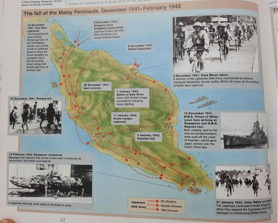
Image source: Encyclopedia of Malaysia: Government and Politics (1940-2006), Page 22

Battle of Jitra
Jitra, a sleepy hollow in northern Malaya, was about to become a battleground. As the Japanese juggernaut from the Seiki Detachment advanced southwards, a sense of dread settled over the British defenders.

The British plan was simple: hold the line with two brigades, the 15th Indian Brigade on the right and the 6th Indian Brigade on the left. A makeshift bunker at Changlun Timah, a roadblock hastily constructed, was meant to slow the Japanese advance. Several bridges were to be blown up along the Trunk Road and the main bridge over the Sungei Bata. However, the Japanese, with their characteristic ruthlessness and efficiency, had other plans.

The Japanese, on the other hand, were a well-oiled machine, having repaired damaged bridges, bypassed the British defences and launched a surprise attack on the Changlun Timah outpost. The defenders, caught off guard, were overwhelmed. The Japanese tanks, relentless and unstoppable, tore through the British lines, leaving chaos and destruction in their wake.

Meanwhile, a miscalculation by the British further compounded their woes. Mistaking a friendly force for the enemy, they destroyed a vital bridge at Manggoi River, cutting off vital supply lines. The Japanese, seizing the opportunity, exploited the confusion and pushed deeper into British territory.

British Order of Battle at Jitra, 11th Indian Division (Major General D. M. Murray-Lyon)

BrigadeUnitsRole
15th Indian Brigade (Brigadier K. A. Garrett)1/Leicestershire Regiment, 1/14th Punjab Regiment, 2/9th JatsRight Flank
6th Indian Brigade (Brigadier W. O. Lay)2/East Surrey Regiment, 1/8th Punjab Regiment, 2/16th Punjab RegimentLeft Flank (coastal)
28th Indian Brigade (Brigadier W. St. J. Carpendale)3 Gurkha BattalionsDivisional Reserve
155th Field Regiment Artillery Support
22nd Mountain Regiment Artillery Support
80th Anti-Tank Regiment Artillery Support

As the British retreated, the 28th Brigade was tasked with reinforcing the beleaguered 15th Brigade. The 28th Brigade, led by a determined commander, managed to halt the Japanese advance in several key engagements. However, the overall situation remained grim. The British, outnumbered and outgunned, were struggling to contain the relentless Japanese onslaught. The British retired in disorder towards Gurun, 30 miles along the Trunk Road to the south. The fate of Malaya hung in the balance.

Battle of Kampar
After the disastrous defeat at Jitra, the British forces retreated to the Kampar line, a defensive position that offered some natural advantages. Brigadier A.C.M. Paris, temporarily commanding the 11th Indian Division, hoped to hold the line and buy time for reinforcements to arrive. However, the Japanese 5th Division, led by Lieutenant General Matsui Takuro, was relentless. The Japanese launched a series of attacks, but the British defenders, though outnumbered and outgunned, fought with courage and determination.

The Japanese, however, were not to be denied. They launched a flanking manoeuvre, landing troops at Hutan Melintang. This move threatened to cut off the British supply lines and outflank their positions. Faced with this imminent threat, Brigadier Paris was forced to order a withdrawal. The Battle of Kampar, though a valiant effort, marked another significant setback for the British forces in Malaya.

Battle of Kuantan
The coastal town of Kuantan became the next battleground, with the 22nd Brigade tasked with defending the vital airfield. The British had fortified the beaches with pillboxes and barbed wire. The Japanese, ever relentless, launched a two-pronged attack on Kuantan. The Takumi Detachment advanced directly towards the town, aiming to capture the vital airfield. Simultaneously, another Japanese force attacked from behind, infiltrating through the rugged terrain of the Jabor Valley.

The fighting was fierce, with both sides suffering heavy casualties. Lieutenant Colonel Cumming, leading the 2/12th Frontier Force Regiment, displayed extraordinary courage in the face of overwhelming odds. Despite being wounded twice, he led his men in a desperate counterattack, buying precious time for the British forces to withdraw. His heroic actions earned him the Victoria Cross.

The fall of Kuantan marked another significant setback for the British. The loss of the airfield deprived the Allied forces of a vital airbase, further weakening their ability to resist the Japanese advance. As the British retreated, the shadow of defeat loomed large over Malaya.

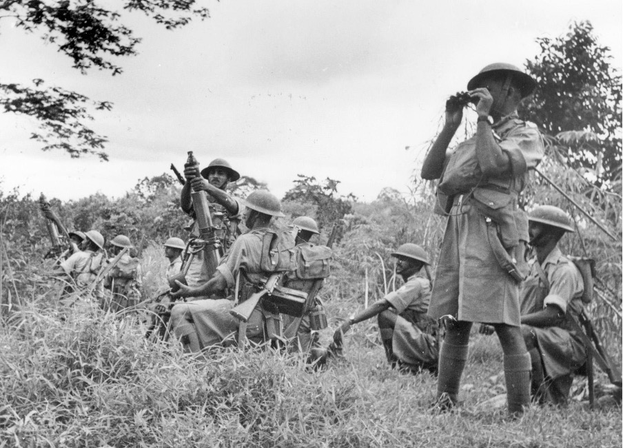
Standing their ground in the dense jungle of Malaya, Indian soldiers fire trench mortars from a tapioca patch at the oncoming Japanese. Image source: https://warfarehistorynetwork.com/article/the-fall-of-malaya-japanese-blitzkrieg-on-singapore/

Battle of Slim River
The battered British forces, reeling from the defeat at Kampar, retreated to the Slim River line. The dense jungle on either side of the road and railway track offered a semblance of security.

The Japanese, relentless as ever, launched a surprise attack in the early hours of the morning. Tanks rumbled through the jungle, their tracks tearing through the dense undergrowth. The British, caught off guard, were overwhelmed by the sheer force of the Japanese assault. Communication lines were down, and units were isolated, struggling to coordinate their defences. The British, unable to coordinate an effective defence, were forced to retreat.

The Fall of Kuala Lumpur
The relentless Japanese advance continued, and soon the heart of Malaya was within their grasp. Kuala Lumpur, the bustling capital city, fell to the invaders on January 11, 1942. The Japanese, utilising bicycles to swiftly maneuver through the dense jungle, outmaneuvered and overwhelmed the British defenders.

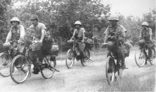
Riding bicycles, a Japanese unit rolls rapidly forward, when the tires went flat, the soldiers continued to ride on the metal rims. Image source: https://warfarehistorynetwork.com/article/the-fall-of-malaya-japanese-blitzkrieg-on-singapore/

Battle of Gemas
The final chapter of the Malayan Campaign unfolded in the southernmost state of Johor. The Australian forces, now tasked with defending the beleaguered peninsula, faced a daunting challenge. The Battle of Gemas was a desperate attempt to slow the Japanese advance. Australian troops, under the command of General Bennett, planned an ambush to inflict heavy casualties on the enemy. However, a series of tactical errors and logistical failures undermined the plan. The retreat from Muar, a crucial defensive position, further weakened the British defenses. The surviving troops were forced to withdraw to Parit Sulong, where they faced another brutal battle.

As the Japanese closed in on Johor Bahru, the British were forced to make a difficult decision. To deny the enemy a vital bridgehead, they destroyed the Johor Causeway, severing the land link between Malaya and Singapore. With the fall of Johore, the British were forced to abandon Malaya and retreat to the island fortress of Singapore.

And then a hero comes along…
The fall of Singapore was a devastat
ing blow to the British Empire. However, even in the darkest hours, acts of extraordinary bravery emerged. One such act was the heroic last stand of Lieutenant Adnan Saidi and his men at Pasir Panjang.

Adnan, a young Malay officer, led his troops in a desperate defense against the invading Japanese forces. Outnumbered and outgunned, they fought with courage and determination, holding off the enemy for days. The battle at Pasir Panjang became a symbol of resistance and sacrifice, inspiring generations of Malaysians.

Adnan, a true patriot, paid the ultimate price for his bravery. He was captured and executed by the Japanese, but his legacy lives on. He is remembered as a national hero, a symbol of courage and sacrifice.

The Japanese, with a formidable force of approximately 70,000 troops, needed just 68 days to conquer the Malay Peninsula and Singapore—one of the most decisive victories of World War II. Following this swift campaign, northern Borneo succumbed shortly after, with Sarawak and British North Borneo falling under Japanese control by the end of January 1942, facing minimal resistance.

The fall of Malaya was a turning point that reshaped Southeast Asia’s political and military landscape. It exposed the vulnerabilities of colonial powers and the impact of underestimating an adversary. Zafrani Amran’s analysis highlights the complexities of this campaign, reminding us that history’s lessons are as vital today as they were then.

About the speaker
Zafrani Amran hails from Kota Bharu, Kelantan, a place rich in history and significant as the site of the Japanese landing during World War II. Growing up, Zafrani often visited the beach, where he saw the pillbox and heard harrowing tales of Indian soldiers, chained inside, forced to fight against the Japanese. His father, who grew up during the Japanese occupation, also shared vivid accounts of life during that time. These stories sparked his curiosity and ignited a lifelong passion for uncovering and preserving stories from the Japanese occupation of Malaya.

Reference and Reading Material:
‘Sir, They Sunk Our Battleship’: HMS Prince of Wales Changed History Forever by Maya Carlin (https://nationalinterest.org/blog/buzz/sir-they-sunk-our-battleship-hms-prince-wales-changed-history-forever-210230)

Operation Battle of Jitra from https://codenames.info/operation/battle-of-jitra/

The Fall of Malaya: Japanese Blitzkrieg on Singapore from https://warfarehistorynetwork.com/article/the-fall-of-malaya-japanese-blitzkrieg-on-singapore/

First shot in the Pa­cific war: What hap­pened in Kota Baru 75 years ago to­day, when the Ja­panese ar­rived from https://www.pressreader.com/malaysia/the-star-malaysia-star2/20161208/281603830092588

Malayan Campaign from https://www.nlb.gov.sg/main/article-detail?cmsuuid=f2e9428f-c2cc-4c21-8a33-6ba79d03d77e

For Valour : Squadron Leader Arthur Stewart King Scarf (37693) VC Royal Air Force from https://www.rafmuseum.org.uk/blog/for-valour-squadron-leader-arthur-stewart-king-scarf-37693-vc-royal-air-force/

Commerating the Historical Event of Bukit Chandu and Lt Adnan Saidi from https://mymilitarytimes.com/index.php/2021/02/14/commerating-the-historical-event-of-bukit-chandu-and-lt-adnan-saidi/

Bank Negara Museum tour 

By Aishah Nadirah

One Thursday morning, more than 20 MV’s gathered at the lobby of the Bank Negara Museum (BNM). I’ve often heard many good things about the museum and was incredibly grateful to be able to join this tour. Visitors were greeted by the grand spiral staircase in the middle of the museum’s hallway and by 10a.m., it was packed with tourists and buses of school children.

The tour was divided into 3 galleries: the Economics Gallery, the BNM Numismatic Gallery, and the latest gallery Masih Ada Waktu.

It kicked off with the first gallery led by En Nazran; the gallery’s definitely a boon for any economics’ enthusiast or those curious about Malaysia’s trading history. Immediately it became clear why there were so many school children in the museum. The interactive exhibits were an essential part of the museum, bringing life to the serious numbers and statistics all over the wall. En Nazran noted that the interactivity is key in the museum, which allows communicating with visitors more efficiently so they won’t have to rely wholly on a museum guide. 

The history of Malaysia’s economic growth started with Malaysia’s natural resources, a history of which parallels that in Gallery C of Muzium Negara. It then transitions to Malaysia’s modern-day economics, displaying a switch from a resource-mixed economy to a financial information sector. 

Another standout display was the history of trading currency used in the Malay archipelago following the arrival of international traders from Spain, Holland, Portugal and Great Britain to the East Indies in the 16th century. Here, Encik Nazran shared the etymology of the word ‘ringgit’, which came from the jagged edge of a coin or in Bahasa Malaysia, ‘beringgit’.

The last 3 exhibits focused mainly on the nation’s modern economy, from Malaysia’s financial sectors’ development e.g. the prestigious institutions of Maybank, RHB, to the Asian financial crisis and a quick skim of the past governors at the helm during the crisis. The penultimate display was a history of all recorded world economic crises up to the last 2020 Covid crisis. Encik Nazran pointed out the arguably most interesting one: the tulip and bulb craze in the 1630s, where people would go so far as to sell 12 acres of their land for just one bulb of tulip. This led to a tulip and bulb bubble, which wasn’t sustainable and short-lived.

Next came the highlight gallery of the museum: the BNM Numismatic Gallery. Located on the second floor, this tour was guided by Puan Ilyana. It opened with the golden era of the Malay archipelago as the strategic centre of trade, a piece of history familiar to the MVs. There was a wall decorated with a reimagination illustration of Melaka as a trading centre and beside it, an exciting simulation game teaching on the barter trade system.

The next exhibit featured currencies found during the old Malay kingdoms. Displayed in a glass case, as well as its information projected on to the screen above it, many coins were on display in the dark room, giving it an important atmosphere. This flow, Puan Ilyana informed us, was inspired by the Malaccan river, where some of those very coins were discovered. This part of the gallery was a little narrow for the 20 or so of us museum volunteers but the screen was a welcome visual aid for those who weren’t able to catch a peek of the coins. The main attraction in the numismatic exhibit was the Kelantanese coin from the 17th-18th century used during the reign of legend Che Siti Wan Kembang. It was of a kijang emas (deer) which is now emblazoned as Bank Negara Malaysia’s corporate logo –– the first gold coin from Kelantan. Given its gold content, the coin is also valued at current gold prices.

Pn Ilyana took the time to answer each and every question from us. One interesting fact shared by her was that animal tokens, as seen in Gallery C of Muzium Negara of Muzium Negara, were not for transactional use. Instead, it was used as symbolic tokens for belief. For example, a trader would carry around the tortoise token with the belief for longevity.

The walls in the numatic gallery were lined with even more interactive games, bringing the history of coins to life. A personal favourite was one interactive wall featuring historic currencies used in the Malay archipelago, where we match the comically large token to its facts. Not only do we learn these interesting facts, we also get to admire the different currency designs from the different states. One that came to mind is the Johor currency during Sultan Sulaiman Badrul Alam Shah’s reign – it had a doughnut hole in the middle reminiscent of modern Danish currency 1 krone.

Another exhibit that stuck out was the wall of commemorative currency displaying the huge RM600 bill created in conjunction with the 60th anniversary of the signing of the Federation of Malaya Independence Agreement. According to the Guiness World Records, this was the world’s largest legal banknote in production.

The creation process of the ringgit also was featured, where it involved blending a special mix including polymer and cotton. Pn Ilyana pointed out that’s why the ringgit doesn’t get destroyed in the wash! Interestingly, the raw material blend were available as souvenir pens in their BNM Giftshop at the ground floor.

The numismatic gallery ended with a feature of international currency notes, arranged in alphabetical order. Here, Pn Ilyana shared how any Malaysian ringgit with a scratch on the Agong’s face is considered damaged and holds zero value.

The final exhibit was BNM’s temporary exhibit, Masih Ada Waktu: Sediakan Payung Sebelum Hujan (‘There’s Still Time’), an exhibit aimed to encourage young ones to save. This tour was led by one of the exhibit’s curators, Ms Gabrielle. Walking in was a huge contrast to the previous gallery: unlike the numismatic gallery’s dark and serious atmosphere, this one was brightly coloured and felt incredibly welcoming to children. Ms Gabrielle explained that due to the heavy nature of the content, the exhibit was divided into 4 sections: history of saving boxes, Malaysia’s history of saving, the kids corner featuring tips and tricks for daily savings, and lastly the technical details of saving.

In the first part of the exhibit, we learnt about the piggy bank –– specifically, the ‘celengan’ or the Javanese piggy bank. Most of these piggy banks were originally found in the capital of Majapahit and in the shape of a pig, a symbol of strength and prosperity.

The most interesting thing in the Masih Ada Waktu exhibit, personally, was Malaysia’s history of saving, showing the government’s efforts in encouraging saving nationwide, especially in rural areas. Saving stamps were used at post offices to make saving more convenient for folks staying in the outskirts as banks were located too far away in the city. Interestingly, banking books all over the peninsular differed in design by states. Majority of MVs were also excited at the mention of kootu funds, especially when Ms Gabrielle pointed out that it was illegal when more than 10 contribute or the ibu kutu (leader of the kootu funds) charges interest. It then trails to other collaborations with individuals such as Malaysia’s beloved illustrator Dato’ Lat in the saving campaign, as well as smaller artists selling money banks up to RM2,000.

Finally, the campaign ends with a poppy coloured lifesized snakes-and-ladders game for children to learn as they play about saving habits and even debt. Overall it’s an exhibit that should not be missed, especially for parents, teachers and guardians of young ones. Ms Gabrielle, who also is part of the BNM Marketing team, proudly notes that other central banks visit BNM for guidance on how to make their museums more engaging such as those from Czech Republic and Pakistan. BNM has also several international museum awards under their belt, as well as Accessibility Sejagat award by DBKL. The tour was a highly recommended experience and would definitely be paying another visit to the BNM museum very soon.

MV Focus 2024 Trip To Gua Niah National Park, Sarawak

Written by Serena Yee

In October, 21 MVs made their way to Miri for the much-anticipated visit to Gua Niah National Park in Sarawak. 

Niah National Park was established in 1974 within the Bukit Subis Protected Forest that was established under the Forest Ordinance in 1951. It is protected by the National Parks and Nature Reserves Ordinance and the Wildlife Protection Ordinance of 1988. At the state level, the property is protected by the Sarawak Heritage Ordinance 2019. The Sarawak Forestry Corporation takes the lead in managing the park in collaboration with the Sarawak Museum Department, who is responsible for the conservation of the cultural heritage. The management system is supported and advised by the Special Park Committee for Niah National Park.

A chartered bus ride of an hour plus long brought us to the park headquarters from our hotel in Miri town. Together with Assistant Curator of the Sarawak Museum, Mohd Sherman Sauffi and 3 Sarawak forest rangers, we set out with a slightly anxious albeit enjoyable 3-minute boat ride across the croc-infested Niah River to the start of the trail. Careful to limit each trip to 10 persons so as not to capsize the boat! 

Pleasantly traipsing on hardwood raised boardwalks and cement paths in alternation, resting briefly at the Tangap Community Craft Stalls and Washrooms, we soon arrived at the Traders Cave. Like eager little beavers, we pushed on towards the Great Cave Complex, leaving this for later.

Moon Cave

The Great Cave Complex was really very dark. Within it was the Moon Cave (Lobang Bulan) one of the darkest caves in Niah, which was surveyed in 2014-2015. Millions of years ago it was underwater, evidenced by the salt residue, seashells and an ancient riverbed. 

The prehistoric people knew how to select the right spots to settle and this was not one of them. They preferred rock shelters and cave openings. This was however the main cave for the collection of edible birds nests, made from the saliva of swiftlets high up in the roof and walls of the cave. The incessant chirping and squeaking of swiftlets and bats (apparently there are 7 or 8 kinds here!) accompanied us as we laboured up and down multiple flights of steps through the cave at an elevation of 3000+m. Here and there were metres-long ropes, wooden/bamboo poles and flimsy-looking ladders extending from eye level to the roof erected by the birds’ nest collectors. It was a sight to see! And to spare a moment for those who lost their lives pursuing this profession in the dead of night.

Before arriving at the Painted Cave, we passed by Gan Kira (no one knows the origin of this name) where the soil/clay is harvested to make the prehistoric pottery found in this area. Adjacent is where Barbara Harrisson discovered the mysterious headless skeletal remains of a prehistoric female, hence the name Murder Cave.

Painted Cave

A few more kilometres after that we arrived at the Painted Cave (Gua Kain Hitam), the furthest point today. The famous murals of the Niah Caves were discovered here, featuring images of the ships of death, which serves as a prominent drawing on the cave wall. The remains of the ships of death (boat-like coffins that were used to contain the bodies of the dead) have been transferred to the Sarawak Museum.

Sherman produced the magic key and we felt great privilege entering the fenced off area, eyes eagerly scanning the walls for the red ochre (hematite) drawings we had seen many times in Gallery A, at the National Museum. He then directed us to the back of the cave and when he shone his torch on the wall, there was a collective gasp as we saw many drawings there in greater clarity! The 45m long wall is divided into 4 sections, 3 and 4 being the furthest in. 1 and 2 being on the outer part of the cave more exposed to the elements, hence the drawings are comparatively less clear there.

122 drawings, dating from 1800 to 800 years old, were catalogued by Barbara Harrisson in 1959 but in 2016-2017, using a spectrum camera, archaeologists re-catalogued a total of 164. Encompassing anthropomorphic, zoomorphic and geometry, there were drawings of boats (Ships of Death), symbolising the journey to the afterlife, animals, a shaman, a symbol of the universe to name a few. We are currently restricted from sharing any photos of these drawings due to the ongoing research and analysis that has yet to be completed.

A number of wooden coffins were also found here used in the practice of secondary burials. There were three sizes : sub-adult, teenager, and adult. The body is first laid there upon death where the holes at the ends allow bodily fluids to flow out. After a few years the bones are collected and buried in another place. A joint team led by Associate Professor Stephen Chia in 2007-2008 discovered 6 Neolithic skeletal remains nearby, dating 2000 – 3000 years old, beyond the fence, in an area referred to as Cave B. They were buried within a depth of 1-1.5m. Why were they not buried in the Painted Cave? Because it was primarily a dwelling as the soil layer was only 5-7cm deep, after which one would hit bedrock, thus not suitable for burials. 

An unusual watermark is seen on the ceiling of the Painted Cave. Researchers hypothesise that it could be due to the mist, moisture, humidity, air circulation, temperature fluctuations, the wet and dry seasons coming from the opening of the cave.

The Great Cave

We then headed back to the dark Great Cave, through the ups and downs again, to enter another locked area at the West Mouth (Lobang Kuala) of the cave. Here, Sherman had to bring us 5 at a time due to the fragility of the walking planks, sharing with us in detail the discovery of the 40,000 year old Deep Skull in Hell Trench below a few metres of guano. Deep Skull is a fragment of a skull discovered in February 1958 in the first Niah excavation led by Tom and Barbara Harrisson after a tip-off from the locals. This area near the mouth is pre-Neolithic.

Further in is the excavation of a Neolithic ‘cemetery’ dating from 2800 to 1200 years ago, showing their awareness of the differentiation between the living and the dead. 200 individuals were found in 7 different burial methods/positions, namely, flexed, seated, cremated, mutilated, burnt, layered and supine. Some even had different hand positions. The many variations of mortuary treatments represent one of the Outstanding Universal Values (OUV) of The Archaeological Heritage of Niah National Park’s Caves Complex that accorded it its UNESCO World Heritage Status on 1st August 2024. 

Another unique find was a jade earring (lingling-o) which was excavated on 29 March 1977 by Dato Professor Zuraina from a burial. Recent analysis showed that its mineralogical characteristics resemble those of Fengtian nephrite from eastern Taiwan, about 2500 km to the north. Similar earrings were found in Batanes and Palawan in the Philippines where it could have been manufactured and then traded in Borneo. 

With evidence of long-term human habitation and near continuous occupation from 40,000 – 2,000 years ago, Niah is among the most important sites in Southeast Asia. Meanwhile, MVs waiting their turn were in stitches regaled by Kulwant with stories from the Milo Chronicles!!

Traders Cave

Finally we made it back to the Traders Cave, previously known as the Small Cave, but renamed for the traders of guano and birds nests who conducted their business here in the 1950s. Their lashed-lug (pasak) stalls were constructed with ironwood (belian). Excavations were carried out here in 2017 and 2019 with the University of New South Wales. 14 trenches were dug, 6 layers identified. Hitherto findings are roughly illustrated in the following table.

Traders Cave, Niah Caves Complex : Archaeological Findings and Age Estimates 

Layer DepthAge Range (Years Ago)FindingsSignificance
Top Layer (10 cm)40,000Surface layer, recent deposits
Lower Layer55,000 – 65,000– Human toothIndicates early human presence
– Human skull pieceImportant for understanding mortality and health
Layer 375,000 – 85,000– SeashellsEvidence of marine environment
– Fish bonesSignifies dietary practices
– Crocodile back plateAdds to knowledge of local fauna
Layer 4 (2.5m down)120,000– BedrockIndicates the base of the site
Oyster Layer75,000 – 85,000– Oyster remainsShows that the area was underwater
– Microlithic toolsSuggests human tool-making activity

These findings are under peer review and research is still ongoing. Hopefully in the near future, researchers will be able to piece together the story of the ancient settlements here.

Therein lies Niah’s main Outstanding Universal Value (OUV) – the continuity of the prehistoric occupation, the longest-known records of human interaction with rainforests within a colossal complex of caverns and caves of the Integrated Niah Cave Complex. With evidence dating as far as 65,000 years, extending to a more recent period of activity just 800 years ago. Who knows what will be discovered in the future. For certain, we were all privileged to have visited it.

References:

https://whc.unesco.org/en/list/1014/

The Secret of The Moon

MV Focus Talk with Emna Esseghir

Written by Noriko Nishizawa 

Zitouna mosque in Tunisia with full moon view (photo : http://www.tunisi.info)

On the eve of Ramadan 2024, our fellow museum volunteer, Emna Esseghir, gave us a very insightful talk about Ramadan. Emna hails from Tunis, Tunisia, and has been residing in Malaysia for the past six years. She has been a passionate volunteer guide at Muzium Negara since 2023. We affectionately refer to her as our Tunisian ambassador to Malaysia, as she has generously shared her knowledge of Tunisia and its culture with us. Her presentation provided a unique perspective on Islam, encompassing not only Tunisia and Malaysia but also offering a cross-cultural examination of Ramadan and Eid al-Fitr traditions and practices.

Emna Esseghir (photos: Noriko Nishizawa)

Brief History of Islam

It is believed that Islam started in 610 CE when 40-year-old Muhammad, who was born in Mecca in western Arabia, received his first revelation from the angel Gabriel. The night Gabriel appeared to him in a cave during a retreat is called the Night of Power/Destiny (Laylat al-Qadr).

Gabriel said to Muhammad, “Read in the name of your Lord…” until he learned the words by heart. The messages from Gabriel continued for the rest of his life, and these revelations were subsequently collected and codified as the Qur’an (literally “to read/recite” in Arabic), the Muslim holy book. The essence of Gabriel’s messages was simple: it affirmed the existence of one god, Allah, and declared that Muhammad was his appointed messenger. The messages also provided guidelines for proper behavior within the framework of a just and equitable society. Around that time, Mecca, the religious center, was a prosperous city, and the Kaaba, then a shrine and a place of pilgrimage housing the pagan deities, was worshipped by the Arabs. The Prophet Muhammad’s messages weren’t well received among the leaders of Mecca. In the face of opposition and persecution in Mecca, Muhammad and his followers emigrated north to another oasis town, Medina (Yathrib) in 622. This event, referred to as Hijrah/Hegira, proved to be a turning point for Islam because it marks the formation of the first community of Muslims. Muhammad continued to attract followers in Medina and also to fight off attacks against him and the faith with his army. Within a few years, Mecca largely embraced Islam as well, and the first thing Muhammad did upon his return to Mecca was to remove idols and rededicate the Kaaba to Allah. The Kaaba, which is a stone building, has become Islam’s holiest site, the Masjid al-Haram, and no matter where they are, Muslims always face in the direction of the Kaaba for prayer.

Leave from the Blue Qu’ran and The Spread of Islam at IAMM (photo: Noriko Nishizawa)

Muhammad died in 632, and the following 30-year period is called the Rashidun (rightly guided) Caliphate, led by a series of four caliphs. A caliph (a successor) is a representative of the Prophet who governs the Muslim community, both politically and religiously in the early period, and a caliphate is a political community governed by a caliph. First, Abū Bakr, who was Muhammad’s father-in-law and a close associate, was elected as the first caliph and then followed by Umar, Uthamān, and Alī. Under their commands, the Arab armies expanded the new faith and leadership in the Arabian Peninsula and beyond. They then conquered Syria, Palestine, and Egypt from the Byzantine Empire, and Iraq and Iran from the Sasanian Empire. The next caliphate, the Umayyad, conquered territory from Spain and Portugal all the way to India and Pakistan by the end of 750. The Ayyubid Caliphate became the largest and most powerful empire in the world by developing a religious, political, and cultural commonwealth. Interestingly, the conversion to Islam in the early period was quite slow because the expansion of the empires happened so fast. On the other hand, the spread of Islam in regions where Muslims are quite numerous today, like Indonesia, Malaysia, and sub-Saharan Africa, happened between the 13th and the 15th centuries quite quickly, through merchants and religious scholars.

(Source: Wikimedia.org, this file is licensed under the Creative Commons Attribution-Share Alike 4.0 International license)

Emna showed us this map: Map of the Muslim World With the Main Madhhabs. She emphasized that as of 2020, there were 1.8 billion people, more than 25% of the world’s population, who practiced Islam, and Muslims were not only in Arab countries but also everywhere. Then she touched on the two main branches of Islam and some madhhabs/mazahib, referring to Islamic schools of thought. Sunni and Shia/Shīʿa are the two main branches of Islam, and around 85% of the Muslim population are Sunnis, with 15% being Shias (source: the Council on Foreign Relations). While Shias are concentrated mainly in Iran, Iraq, and Lebanon, Sunnis are the majority in more than 40 other countries. These two sects within Islam share most of the fundamental beliefs and practices of the religion, but they differ in doctrine, law, ritual, and religious organization.

The roots of the Sunni-Shia division can be traced back to the seventh century, soon after the death of Muhammad. Shias believe that Muhammad publicly designated Alī, his cousin and son-in-law, as the first in line of hereditary Imams (“leaders” in Arabic) from his family, whereas Sunnis believe that Muhammad did not explicitly declare a successor. Sunnis viewed the caliphs as both religious and political leaders in the early period. Over time, the caliphs functioned as political rulers, while the scholars (Ulamā/Ulema) were considered religious authorities and interpreters. For Sunnis, Imam is most commonly used as the title for a prayer leader at a mosque. In contrast, for most Shias, Imams are absolute leaders of the Islamic communities, since they believe that Imams should be spiritual descendants of Muhammad and are responsible for interpreting the faith, as well as improving the quality of their lives.

(Source: Calligraphy showing the word Allah in Arabic in Hagia Sophia, Istanbul, Turkey by Adam Kliczek, http://memoriesstay.com)

Madhhab means ‘a way’, and it is a method of interpreting the religion that binds a group or school of scholars together. Today, there are four major Sunni madhhabs: Hanafī, Hanbalī, Mālikī, and Shafi’i. For example, Tunisia is mostly Mālikī and Malaysia is Shafi’i. According to Emna, we don’t really see differences between Mālikī and Shafi’i in our daily life, but Mālikī, also called the ‘school of Medina’, could be a little more flexible in terms of customs and traditions compared to other Sunni madhhabs.

Understanding Ramadan: What You Need to Know About Ramadan

Overall:

(1) The term “Ramaḍān (رَمَضَان)” originates from an Arabic root denoting “extreme heat” or “dryness”. 

(2) Ramadan is the ninth month in the Islamic calendar and is considered one of the holiest months because it is devoted to fasting, one of the Five Pillars of Islam which are the core beliefs and practices of Islam.

(Source:  The Ultimate Guide to The 5 Pillars of Islam by Resala Academy)

(3) Ramadan existed before Islam.  Ramadan is said to have been an important and holy month for the Arabs long before Muhammad introduced Islam.  They stopped fighting and tried to meditate at temples and caves during that time.  Muslims believe that the Night of Power happened during Ramadan.

The Islamic Calendar/The Hijri Calendar:

(4) The Islamic calendar plays an important role in the life of Muslims as it specifies the time for Ramadan, Eid al-Fitr, Hajj, etc.  Little is known about the pre-Islamic calendar; however, some historians maintain that it was similar to the modern Islamic calendar.  Although Arabs were already using the calendar based on lunar months, they didn’t have a specific number or term to register the year, and it became quite confusing.  As a result, the second caliph, Umar, introduced the new calendar in 639.  The Islamic calendar is a lunar calendar, and the Hijrah in 622 marks the beginning of the calendar.  It symbolises the Muslim’s journey to fulfill all the Five Pillars of Islam: renewing the faith constantly, performing prayers, paying annual Zakat (a financial obligation to donate to charitable causes), fasting in Ramadan, and fulfilling the Hajj (a once-in-a-lifetime pilgrimage made to the Kaaba).

Fasting

(5) Fasting was already a common religious practice among the pre-Islamic Arabs, and they used to fast on Āshūrā (the tenth day of Muharram) to observe the day God parted the Red Sea to allow Moses and his people to escape Egypt.  Muhammad also used to fast on Ashura.  Actually, Ashura has become an important mourning day for Shias, because it was the day Imam Husayn ibn Ali, the grandson of Muhammad, was martyred in the battle.  Even today many people still fast on Ashura.  As for the fasting during Ramadan, it is believed that Muhammad received a revelation regarding Sawn (fasting) from the angel Gabriel two years after Hijrah, and then he established fasting as one of the holy month’s (Ramadan) practices.

(6) Food and drink aren’t the only things Muslims have to abstain from.  There are other activities they also cannot participate in to cleanse their mind and soul. Fasting is obligatory for all Muslims who have reached the age of puberty, who are of sound mind, and who have good health.  However, those who are in pre-puberty, old and frail, sick, pregnant, breastfeeding, menstruating or travelling are excused, but there are other requirements they must abide by.

(7) Sunni and Shia practice fasting slightly differently.  Sunnis break their fast as soon as the prayer (maghrib) starts as the sun is no longer visible on the horizon.  Whereas Shias wait until the end of the prayer which  starts when the last ray of light vanishes and the sky becomes totally dark.

(8) Fasting is an act of worship bringing one closer to God, as well as a form of spiritual discipline and a means to empathize with those less fortunate. 

How to Observe Ramadan:

(9) Ramadan begins 10-12 days earlier each year because the Islamic calendar year is shorter than the Gregorian calendar, allowing it to fall in every season throughout a 33-year cycle.  The Islamic calendar follows the literal cycles of the moon, and each month of the calendar begins with the sighting of the early crescent moon.  Telescopes as well as astronomical calculations and technology are used to establish the moon’s appearance.  Consequently, the exact start of Ramadan is not confirmed until the day before, although an approximate start date is calculated in advance.  Also the exact timing varies from country to country, depending on when local Islamic authorities in each country declare the sighting of the new moon.  It is the same for the end of Ramadan.  Emna told us that in Tunisia’s case, the country still sent out someone in each state to a higher place to sight the moon.  It would be good enough to start Ramadan if even one of them (24 states) spots the moon.

(10) Ramadan is not all about fasting.  Some of the special practices during Ramadan include eating a special pre-dawn meal called suhoor/suḥūr before starting the daily fast at dawn, and then eating another meal called Ifṭār to break the fast at sunset.  During Ramadan Muslims also take part in extra worship such as Tarāwīḥ/Taraweehprayers (night prayers) observed by Sunnis in addition to the five daily prayers: Fajr (dawn), Zuhr (afternoon), Asr (late afternoon), Maghrib (after sunset), and Isha (night time).  Also, towards the end of Ramadan, many Muslims make a special charitable donation which goes to the less fortunate.

(Source: Tarawih prayer at the Great Mosque of Kairouan, Tunisia by Zied Nsir – this file is licensed under the Creative Commons Attribution-Share Alike 3.0 Unported license.)

(11) The Night of Power is one of the most sacred nights in the Islamic calendar, and it is believed to be a night of great reward and significance.  This night falls within Ramadan’s last 10 days.  Although it commonly considered as the 27th night, the exact date is unknown.  As a result, Muslims are encouraged to intensify worship and devotion during the last 10 nights of Ramadan, especially during the odd nights (21st, 23rd, 25th, 27th, and 29th ).

Ramadan Customs and Traditions:

(12) It is customary for many Muslims to break their daily fast and celebrate Eid al-Fitr by eating dates.  Of course, dates grow in many Muslim countries and are quite nutritious.  This custom goes back to the beginning of Ramadan, as it is said that Muhammad ate dates to break his fast.  

(13) The Ramadan drummers called Musaherati are one of the most important markers of Ramadan.  Every year these volunteer drummers would roam the streets in their neighborhoods an hour before dawn to wake up people to have suhoor, by drumming, calling out people’s names, and even reciting poems.  In the Ottoman and Andalusia cultures, the drummers even competed to claim who was the best!  Musaherati is another tradition that almost disappeared in most cities.  

(Source: Musaherati by Gulf News credited social media)

(14) The adhān/azan (“announcement” in Arabic) is the Islamic call to prayer, usually recited by a muezzin who chants from a minaret five times a day.  It is not Ramadan specific, but it is important particularly during Ramadan because people wait for maghrib to break their daily fast.  According to Emna, although the call to prayer in each country sounds quite different, the words spoken in prayer are the same or very similar.  The most notable difference in wording are the slight variations between Sunni and Shia.  The beauty of the adhan lies in its melody – the rhythm and tone of the words captivate the listeners and make each adhan sound different.  The adhan was developed during the Ottoman Empire as a creative way for listeners to be able to tell the time of prayer just by hearing the tone of the adhan.

Eid al-Fitr:

(15) Eid al-Fitr known as the “festival of breaking the fast” marks the end of Ramadan and is celebrated during the first three days of Shawwāl, the 10th month of the Islamic calendar.  On the first day, people attend a special communal prayer at mosques during the day and then enjoy a feast with families and friends.

(Source:  Ramadan Food by NetCost Market)

Emna shared many of her own personal experiences of Ramadan and described how festive Tunis was during this special time.  All the shops and restaurants were open throughout the night, and there were many concerts as well.  She said Cairo was even more festive than Tunis!  

Emna enjoyed her mother’s cooking, and during Ramadan her mother made special dishes.  Her mother also prepared a lot of food to share with other people, especially those in need.  In Tunis, sometimes cannons were used for the call to prayer.  We could still experience all of them today.  

Emna concluded her talk emphasizing that Ramadan was not just about fasting, but was rather a time to help each other share joy.

References:

Suzan Yalman, The Birth of Islam https://www.metmuseum.org/toah/hd/isla/hd_isla.htm

Introduction to Islam, Khan Academy https://www.khanacademy.org/humanities/world-history/medieval-times/spread-of-islam

Sarah Pruitt,  Islam’s Sunni-Shia Divide, Explained https://www.history.com/news/sunni-shia-divide-islam-muslim

Ramadan, Britannica  https://www.britannica.com/topic/Ramadan

Indlieb Farazi Saber, The art of the adhan: The multiple melodies of the Muslim call to prayer https://www.middleeasteye.net/discover/adhan-muslim-call-prayer-melodies-maqams

UstazMuhammad Abdul Mateen Bin Hisham, 4 Intriguing Things You May Not Know About the Islamic Hijri Calendar https://muslim.sg/articles/4-intriguing-things-you-may-not-know-about-the-islamic-hijri-calendar

Dima Al-Sharif, AL Musaherati Tradition https://www.dimasharif.com/musaherati-ramadan-drummers/#:~:text=While%20during%20those%20days%20the,created%20specifically%20for%20the%20occasion.

Focus Talk: Sixteen Naked Indians by Dr. Lim Teckwyn

Written by Manjeet Dhillon

22 June 2024: History often focuses on the conquering heroes, the explorers who plant flags and claim new lands. But what about the quiet first meetings with the indigenous communities?

This often-forgotten chapter in history was recently brought to life at our focus talk thanks to Dr. Lim Teckwyn. His talk, titled “Sixteen Naked Indians: First Contact Between the British and the Orang Asli in the Late 16th Century off the Coast of Penang,” challenged our understanding of the island’s earliest encounters with Europeans.
Dr. Lim Teckwyn, an Honorary Associate Professor at the University of Nottingham, Malaysia, whose work focuses on the interface between forests, wildlife, and people, spoke about this historic encounter between British sailors and the indigenous inhabitants off the coast of Penang in the late 16th century.
Early European Arrivals
Dr. Lim first discussed the possibility of earlier European arrivals, including a Greek sailor named Alexandros in the 6th century and a possible Roman vessel around the same period. Additionally, Marco Polo’s potential voyage past the Malay Peninsula during his explorations in China is explored.
The audience is presented with a trivia question: Did the renowned explorer Sir Francis Drake visit Malaysia? The answer is no, as his circumnavigation steered south of Java on the return trip.
While a lesser-known figure, Ralph Fitch, holds the distinction of being the first Briton documented in Malaysia (though he arrived on a Portuguese vessel in 1588), Dr. Lim’s talk focused on Captain James Lancaster, a key figure in early British exploration of the region.

In June 1592, Lancaster arrived in Southeast Asia aboard the Edward Bonaventure, one of the first English vessels to venture into the region. His fleet, initially consisting of three vessels, was reduced to one by the time it reached Penang, largely due to the ravages of scurvy (an illness caused by vitamin C deficiency) and the loss of ships during the journey.

The Encounter
The first recorded interaction between Lancaster’s crew and the indigenous people occurred on the mainland near Penang on August 31, 1592. According to the journal of Lancaster’s first mate, Edmund Barker, the British sailors initially observed signs of recent human activity, such as burning fires, but encountered no people until the following day. When they finally met the locals, they described them as “sixteen naked Indians” in a canoe. This brief encounter, however, offered valuable clues about the identity of the islanders.

Dr. Lim clarified that the term “naked” in Elizabethan English often referred to people who were not fully dressed by contemporary European standards, rather than being completely unclothed. These indigenous people, likely wearing minimal attire, engaged in a friendly exchange with the British sailors, promising to provide fresh victuals (fresh fruit) to help restore the sailors’ health and allow them to continue their voyage.
Dr. Lim’s research suggests that this encounter proved to be a valuable learning experience. On a subsequent voyage, Lancaster implemented a preventative measure by regularly providing his crew with lemon juice, effectively combating the illness.

Orang Asli or Malay? Examining the Clues
The identity of these “naked Indians” became a subject of exploration for Dr. Lim. He suggested that the term “Indians” in this context referred broadly to non-Muslim inhabitants of the region, as opposed to the Muslim Malays, who were often referred to as “Moors” by European explorers of that era. This distinction is crucial in understanding the nature of the encounter and the cultural background of the indigenous people involved.
The canoe described in Barker’s journal, likely a dugout with an outrigger, is consistent with those used by the Orang Asli and other indigenous groups in the region.

Dr. Lim’s extensive research into the Orang Asli provides further context, suggesting that these people were part of the diverse and complex network of indigenous communities inhabiting the Malay Peninsula.
While the evidence for this encounter may be circumstantial, it holds significance as the first recorded contact between the British and the Orang Asli. It offers a glimpse into a period where European influence in the region was nascent and the Orang Asli way of life remained relatively undisturbed.
A More Inclusive Narrative
The Orang Asli, the indigenous people of Peninsular Malaysia, were likely the first to greet the European sailors. Their presence sheds light on a facet of Penang’s history that has been overshadowed by later colonial narratives. This chance encounter, though brief, reminds us to consider the perspectives of the Orang Asli, who inhabited these lands long before European arrival. Understanding these early interactions allows for a more complete and nuanced understanding of Malaysia’s past.

Q&A Session Highlights

The talk was followed by a Q&A session that shed further light on Dr. Lim’s research and the broader context of European exploration in Southeast Asia. Here are some key takeaways:
● Captain James Lancaster’s Voyages: An audience member inquired about Captain Lancaster’s other voyages. Dr. Lim confirmed that Lancaster undertook several expeditions, and the encounter with the Orang Asli likely occurred on an earlier voyage before his more famous exploits aboard the Dragon, a ship funded by the East India Company. He also mentioned that Captain Lancaster was likely knighted for his achievements on a separate voyage.
● The Use of the Term “Malay” Another interesting question explored the possible use of the word “Malay” by Europeans at that time. Dr. Lim suggested that while contact with Malay-speaking people in other parts of the archipelago likely occurred, the term “Malay” in the English language might have been introduced by explorers like Magellan, whose journals were translated soon after their voyages.
● Denisovans The discussion briefly touched upon Denisovans, an ancient human relative. Dr. Lim acknowledged ongoing research on their possible presence in Southeast Asia (referencing twelve skulls found near the Solo River in Indonesia). Their presence is hinted at through DNA markers. Aboriginal Australians, Papuans, and some Filipinos possess Denisovan DNA, suggesting interbreeding between these ancient humans and early modern humans in the region.
Recent genetic studies paint a fascinating picture of human migration in Southeast Asia. The Orang Asli share DNA with people from Melanesia, suggesting ancient connections.

Note:

The Orang Asli (meaning “original people” in English) are the indigenous communities of Peninsular Malaysia. They encompass a diverse network of sub-ethnic groups, each with its own language and cultural practices.
Traditionally, many Orang Asli groups have lived semi-nomadic lifestyles, attuned to the rhythms of the rainforest and practising activities like shifting cultivation, hunting, and gathering.
This encounter with the British sailors in 1592 sheds light on a period when their way of life thrived in relative isolation. Today, the Orang Asli face challenges related to land rights and modernisation, yet their culture and connection to the environment continue to be celebrated.

Ningyo; Japanese beauty of art and culture

Written by Shizuko HOSOKAWA / Miyoko ARIYAMA

A special exhibition of Japanese dolls is now being held in the Central Hall of the National Museum from May 7 to July 8.

The exhibition is supported by the Embassy of Japan in Malaysia and the Japan Foundation, and 67 dolls are on display.

This special exhibition of Japanese beauty of art and culture has been held in many countries around the world.

The exhibition is divided into four sections.

The first section is ‘ningyo to pray for children’s growth’, doll culture in Japan developed out of rites to protect children against misfortune and to pray for their happiness.

The unique Japanese culture of praying to these dolls has been passed down to the younger generations even today.

Traditional Hina dolls were mainly decorated with seven tiers. 

You will see Hina Ningyo of the Hina Matsuri festival at the center of the hall.  They are called ‘Dairi-bina (Imperial couple)’ they are the main dolls used in the Hina Matsuri festival celebrated on March 3rd to pray for the happiness of girls.

The clothing worn by the doll shown here is designed after that worn by the current Emperor and Emperess during a special imperial rites called the Enthronement Ceremony; Sokui no rei in 2019.


Many of you may have remembered the visit of the current Emperor when he was a prince to the National Museum in 2017.

https://www.nst.com.my/news/nation/2017/04/230953/prince-naruhito-fascinated-exhibits-national-museum-kl

The second section is ‘ningyo as fine art’, the evolution of the doll making techniques. Around from the 17th century, sculpting techniques, delicate colours, and finely produced clothing evolved so much.

One of the great production is ‘Isho Ningyo; Maiko.’ Maiko is a young girl who performs professionally at traditional banquets in Kyoto.

The same weave, clothing and needlework is used with the same materials and methods to make the doll’s clothing as is used for actual clothes worn by Maiko.    

The other doll called ‘Saga Ningyo; Enmei fuku no Kami’, the God of happiness and longevity. 

Fuku no Kami is a God who brings good fortune. In his left hand he holds a bag that is filled with all sorts of treasures.

Saga Ningyo are one of the most luxurious Japanese dolls from the Edo period(1603-1868). Its distinctive feature is the finely applied gold leaf and paint on the costumes.

The third section is ‘ningyo as folk art’, featuring traditional dolls from all over Japan.

One of the most eye-catching dolls is the bright red, ball-like round doll Daruma.

The Daruma is a traditional Japanese doll that has been worshipped in Japan for centuries as a symbol of luck, success, and perseverance.

If the Daruma is said to bring good luck, how do we make use of it?

In fact, both eyes of the Daruma are empty when purchased.

After purchase, one eye is painted black when a wish is made. When this wish comes true or a goal is achieved, the other eye can be painted as well. 

Similar to Darumas, the Kokeshi is a doll with no arms or legs, sold as a souvenir at hot spring resorts in the Tohoku region.

In some regions, it is believed that kokeshi dolls were created as a good-luck talisman to wish for the birth and healthy growth of a child. 

Finally, the last section introduces the spread of Ningyo culture.

The reappraisal of dolls as art in modern times drove the emergence of many talented doll creators as works of art. As such, Japan’s doll culture further gave rise to the creation of collector figures which are popular throughout the world today.

Collector figures represent popular characters from games and animation. It is actually very difficult to recreate the 2D characters into 3D in a way that satisfies the expectations of the fans.

Come to the museum if you would like to know more about Japan’s Doll! There are many beautiful dolls for you to see and learn about. 

It will surely be an enjoyable time for you.

>More videos from Japan Foundation (Japanese/English)

>The staff and curator of the National Museum gave an overvies to volunteer guids.

New Research into the History of the Patani Sultanate in the 16th-17th centuries.

A MV FOCUS TALK by Professor Daniel Perret (27th May 2024)
By Hani Kamal

Professor Daniel Perret, the head of the French School of Asian Studies at the Faculty of Arts and Social Sciences, History Department, Universiti Malaya, is currently serving as a visiting professor at the same institution. His research specialises in the history of epigraphy and archaeology in proto-urban sites throughout Southeast Asia. His presentation, titled “New Research into the History of the Patani Sultanate in the 16th-17th Centuries,” focused on investigating the historical aspects of Patani.

Perret and Jorge Santos recently conducted a translation of a substantial collection of articles sourced from European, Japanese, and Chinese historical records. These sources shed light on the extensive trade relationships established by European powers such as the Portuguese, Dutch, and British in Patani during the 16th and 17th centuries. Through their study “Patani Through Foreign Eyes: Sixteenth and Seventeenth Centuries,” published in 2022, Perret and Santos meticulously translated and re-analysed these foreign historical manuscripts detailing the dynamic events within the Patani Sultanate, particularly the reign of four successive queens.

Perret’s presentation emphasised the significance of combining physical evidence, such as monuments and artefacts, with information extracted from ancient manuscripts. These elements provide valuable insights into the events unfolding in the 16th and 17th centuries, showcasing Patani as a pivotal trading hub in the Eastern Seas under the influential rule of these queens. Examples of such artefacts include ancient royal tombstones such as Batu Acheh gravestones, a sketch of the old citadel and manuscripts documenting the legacy of the Patani queens.

Background of Patani

The word Patani originated from the Malay word “pantai ini” (this beach), and as mentioned in Hikayat Patani, it is where a white mouse deer was spotted. In the early days, Patani covered the entire Thai provinces of Patani, Yala, and Narathiwat and included parts of northern Kelantan in Malaysia. According to Hikayat Patani, which was recorded by various authors between 1690 and 1730, the early history of Patani must have been established in the early 2nd century when the strategic cape of Patani was sought after by ships travelling straight from the Gulf of Siam across from the Vietnamese point before going to the Malay Peninsula ports. According to Teeuw and Wyatt’s translated version of the “Hikayat Patani: The Story of Patani”, published in 1970, Patani was believed to be Langkasuka (208BC), situated in a very strategic location geographically ideal for a very complex Asian trade system. Professor Wheatley, in his book The Golden Khersonese, A Study of Asian Historical Geography, concludes that Langkasuka transitioned into Kota Mahligai (now Yarang). But it became almost non-existent when the Srivijaya empire became powerful in the 8th and 9th centuries, dominating the Malay Peninsula. There were major power struggles among the Siamese, Khmer Empire, the Burmese Mon/Pagan Empire, the Cholas, and the Javanese in Southeast Asia during the same period. It is not clear as to when Kota Mahligai became Patani before 1500. However, three main themes emerged in the literary sources on Patani: Siamese influence, its conversion to Islam and its economic rise. (Bougas, 1990: Pg 114)

The peak period in Patani’s history is typically identified as the 16th and 17th centuries. However, by the latter part of the 17th century, the influences of Siamese Sukhothai and Ayuthaya began to dominate the region. In 1902, Siam further weakened Patani’s authority by dividing it into seven districts. The Treaty of Bangkok in early 1909 officially acknowledged Siam’s sovereignty over all the northern Malay territories, thus sealing the fate of Patani ever merging with the peninsula Malay states. Consequently, the Sultanate of Patani was dissolved, and its heir resided in exile in Kelantan. Following World War II, the Treaty of Songkhla in 1949 solidified the inclusion of Patani and the other northern Malay states into Thailand. The ongoing conflict and struggle for independence in Patani persist to this day amid continuing disputes.

The organisation of the Patani capital in early 17th CE

No maps portraying Patani during the 16th and 17th centuries have been discovered. The sole visual representation from that era is a depiction of the city, displayed in Figure 1, which was crafted by Jacob van Neck during his visit to Patani. An intriguing account from 1678 suggests that two trading officers from the British East India Company voyaged to Patani specifically to procure this city map, subsequently dispatching it to their office in Ayutthaya. Regrettably, Perret noted the absence of this document in the British Archives.

The illustration or sketch of the Patani capital, featured in Figure 1, offers a broad overview of the city during the 16th century. Jacob van Neck’s rendering highlights key locales such as the palace, the citadel, various town districts, the merchants’ quarters, and the harbour. This visual portrayal of the Patani capital’s layout is derived from on-site surveys, oral traditions and written accounts documented by diverse sources, including the Malay, Dutch, Portuguese, British, Japanese, and Chinese. Based on field data, it is inferred that this depiction dates back no further than 1584, a pivotal year marking the ascension of the first queen.

In Figure 1, Panarican—which appears eight times in the rutter—or “Penarekan” in Malay, denotes the dragging of boats across the river. “Tanjung Lulo”, appearing seven times in the rutter, is described as a headland on the sandy coastline with two bastions, including the largest in the city and its main gate. Tanjung Lulo is certainly the Tanjung Lulup mentioned once in the Hikayat Patani. Kuala Baca, a sandy beach area, was a town in Patani—it is the “Kuala Becha” mentioned in Hikayat Patani, as well as Dutch and Portuguese sources. On the west coast of the citadel, Garzen, which is frequently mentioned, is likely “Kerisik”, meaning coarse sand. This location fits well with the current location of Ban Kru Se (Kerisik). The “PINTU GARBA” mentioned is the Pintu Gerbang (main gate) in Hikayat Patani, large enough for elephants to pass through, also referred to as Pintu Besar (Big Gate) at the west of the Citadel. Kuala Saba (river mouth of Saba River), north of Panarican, has disappeared in the last four centuries.

Fig. 1. Sketch map of the city of Patani (late sixteenth – early seventeenth centuries) (adapted from Perret et al. 2004).

Portuguese sources—recounting a Portuguese attack on Patani in 1524—recorded Chinese living in brick houses in Patani. Dutch sources cite that Dutch lodges were built with bricks and that the English and Dutch lodged near the bay. The rutter also described the city as having a defence system that served as a channel for communication. According to the sources, the citadel walls were about eleven feet high and seemingly had a very imposing fort. Foreign sources also noted the formidable size of a cannon placed near the Pintu Gerbang. The royal family and Orang Kaya lived within the citadel. A small mosque was also located near the citadel. Salt pans, where salt was produced, were situated north of the citadel.

Similar sources also mentioned how the palace walls were adorned with gilded panels and other wood carvings. This is probably the earliest mention of woodcarving in the northeast state of the Malay Peninsula. The balairung (main royal hall) was described as abundantly decorated with gilded material and velvet-trimmed dais, and the queen sat by a large gilded window. A royal graveyard is also mentioned, and, based on oral tradition, the first Sultan of Patani could have been buried there. The tombstone could have been moved out of the city.

Unfortunately, the city was destroyed by fire four times between 1524 and 1613. By 1786, the Siamese had destroyed the entire city in retaliation to Patani’s assertion of independence.

Ancient Islamic Tombstones

Perret divided the tombstones he found in Patani into three styles: Batu Acheh, Batu Patani Brunei and Bai Sema.

The Batu Acheh tombstones, found across the Malay world, offer a unique insight into the region’s Islamic history. Characterised by sophistication and widespread distribution, these tombstones hold rich epigraphical data. Originating possibly in the 15th century around Pasai, these sandstone monuments signified a departure from local traditions. Although sharing similarities with architectural styles from Central Java and Siamese funerary monuments, batu Acheh was primarily reserved for sultans, high-ranking individuals, their relatives, and possibly affluent merchants. Despite a decline in the 18th and 19th centuries, a resurgence of batu Acheh can still be observed in regions like north Sumatra (Barus), Kedah, Pahang, and Penang.

Batu Acheh tombstones are generally made of sandstone, granites, quartz, river pebbles, marble, cement and wood. The types of material used for the tombstones also give an indication of the economic strength of the state—intricate quartz was used during the 17th century while wood and natural stone were used when the state was in decline. The Batu Acheh tombstones were imported from Acheh and had different shapes, motifs and Islamic Khad inscriptions. The grave of Raja Kuning (the last Queen of Patani) is marked with quartz markers found in Kubo’ Barahom.

Batu Patani Brunei (Figure 2) are tombstones brought in from Brunei. Brunei and Patani were trading partners between the 15th and 17th centuries. Two such grave sites were identified with Batu Patani Brunei in Kampung Parit and Kampung Pintu Gajah. The design was very specific to that found only in Patani and Brunei. It has Chinese motifs, such as clouds. One of the tombstones is believed to be that of the son of the founder of the Sultanate of Patani in the 15th century. It has an Arabic calligraphic inscription stating the son of the sultan on the south side and “Malik bin Mohamad” on the north direction. Unfortunately, no dates were found. Perret postulates that these tombstones could belong to the Brunei people who lived and were buried in Patani.

Fig. 2. Tombstone at Kuboʼ Barahom (D. Perret-EFEO, 1999)

Roeloefsz (1601-2) mentioned the existence of royal graves on the Seberang peninsula and this is the only source citing this interesting information. There were few tombstones found but no indication of a royal one. Ludvik Kalus (2004: 193-206).cited that there were two tombstones found and one of them believed to be the grave of the first Sultan of Patani (Fig.2).

According to oral tradition, Raja Ijau’s tombstone was made in the Bai Sema style (Figure 3), which is heavily influenced by Thai-Buddhist engravings. Originating from India, the Bai Sema designs resemble the Kala-Makara design, which is commonly found in the entrances of temples in Thailand and India. This style may have reached Patani from Trowulan, Surabaya. In Patani, Bai Sema tombstones are very rare.

Fig. 3 Raja Ijau Bai Sema Tombstone (Bougas: Pg 39)

Queen of Patani “The Rainbow Queens”

Female Rulers in the Malay World

When James Brooke visited the Bugis state of Waco, Brooke observed that six out of the eight prominent chiefs were female (Brooke, 1848 I, 74-5). In Islamic Southeast Asia, the presence of female rulers appeared to be a common occurrence. Notably, female Muslim rulers were intricately connected to the realm of commercial trading. Throughout the 15th to 17th centuries, women in these regions played a significant role in engaging in trade activities. For instance, Pasai, the first Muslim state in Southeast Asia, had two queens during its prosperous trading era (1405-1434). Similarly, Japara in North Java emerged as a key naval and commercial hub under the rule of its female queen, Kali Nyamt, in the 16th century.

“Similarly, the women rulers of the diamond-exporting centre of Sukadana in Southwest Borneo (c. 1608-22), pepper-rich Jambi in East Sumatra (163~. 1655), and the sandalwood base of Solor, to the East of Flores (c. 1650-70), were on the throne during the brief period these states were important commercial centres.” (Reid, 2020, Pg 641)

In her research on “Ratu Acheh,” Sher Banu explored the lives of the four Queens of Acheh in the 17th century. The first queen, Sultanah Safiatuddin (1612-1675), took the throne following the death of her husband, Sultan Iskandar Muda. She was succeeded by her daughter, and four Acheh Queens ruled the kingdom for sixty years.

Similarly, a comparable scenario unfolded in Patani during the 16th and 17th centuries, with the kingdom being governed by four consecutive queens. Patani served as a significant trading post, particularly with China, during this period. The preference for female rulers stemmed from the cooperation of the Orang Kaya (male royal councillors and religious ulama) with the queens, recognising their adeptness as rulers with business acumen rather than because they were running out of males to inherit the thrones. During the reign of Raja Ijau:

“Patani the first queen has reigned very peaceably with her councillors … so that all the subjects consider her government better than that of the dead king. For all necessities are very cheap here now, whereas in the king’s time (so they say) they were dearer by half, because of the great exactions which then occurred.” (Van Neck, 1604:206)

Patani, under Raja Kuning, the Orang Kaya, paid less levies as Raja Kuning was a wealthy heiress and a capable businesswoman. The Orang Kaya saw how female rulers were more businesslike and profitable for themselves. They were also mild in ruling the states compared to male rulers.

Raja Ijau, the eldest daughter of Sultan Patik Siam, took power in Patani after the sudden deaths of many male family members. During her 32-year rule, Raja Ijau led an army against Pahang and defended Patani against Ayutthaya, fostering diplomatic relations and promoting culture and art. She is credited with the origins of the Mak Yong dance. Raja Biru continued her mother’s diplomatic legacy and was an adept mediator between the Dutch VOC and British EIC. Raja Ungu defied Siamese rule, aligning with Portugal, Pahang and Johor to repel a Siamese force and further solidify alliances through strategic marriages. Raja Kuning enhanced Patani’s economic prosperity and established it as a prosperous Malay trading post. Following her overthrow by a minister, she retired to Kuantan, Pahang, marking the end of female rule in Patani.

As outlined by Perret, the era of female rulers in Patani was characterised by a decrease in violent incidents and massacres within the royal families. This period was notably peaceful, fostering a sense of safety that encouraged traders to conduct business with relative security. However, following the reign of these queens, the Patani throne shifted to male lineages, possibly influenced by conservative factions aiming to enforce Islamic practices that restrict female leadership over men. The subsequent male rulers exhibited intense competition and a diminished focus on trade, leading to a decline in safety and profitability for Patani as a trading hub during their governance.

The Queens’ Title

Perret noted the Patani Queens used the Indian Sanskrit male title “raja” instead of the Islamic “sultanah” or the Malay “ratu.” Historical sources from Patani do not provide evidence of the title “Sultanah” being used. The discovery of a gold coin inscribed with the words “al-sultana-al muazam” (the great Sultanah) and “Khalada Mulkaha” (May God preserve her government) has led some to speculate that it may have been associated with one of the Patani Queens. Perret pointed out discrepancies between this coin’s inscription and those on coins issued by the Sultanah of Aceh, as well as the absence of coinage from the Queens of Sukadana and Jambi in the 17th century. He further questioned the authenticity of the claim that the Patani Queens ever adopted the Islamic title of Sultanah and pondered why there is a lack of mention in Malay sources regarding minted gold coins.

The Color Names

The Patani Queens were named after colours, and thus, the acronym ‘’Rainbow Queens of Patani’’ was coined by Teuuw and Wyatt. Some scholars likened it to how in Malay tradition, females were given names associated with colours, or that green is an Islamic colour, and Raja Kuning (yellow) had yellow skin and was given the colour yellow. Jocelin de Jong’s documentation in 1961 highlighted the prevalent use of colour names among Malays. For instance, titles like Tun Hitam or Tun Putih were commonly bestowed upon Malay women in Sejarah Melayu. 

Professor Perret suggested that the tradition of using names based on colour could be rooted in religious or traditional beliefs associated with auspicious symbolism. For example, the Katika Lima system—where a day is divided into five periods, and each period is associated with a colour—is directly related to a Hindu god. Each colour represents the time of birth of the queen. A second possibility is that the colour was related to the day/time of birth, like the zodiac. It could also be related to Buddhist influence. In Buddhism, each cardinal points are related to a colour as also with the Chinese belief. It is also believed that names with colours are linked to the traditional culture of Chinese zodiac practises:

“The centre of the system is Vairocana, associated with the white colour, while interestingly, the colours of the four cardinal points correspond to the names of the four queens: North is associated with Amoghasiddi and the green colour; East is associated with Akṣobhya and the blue colour; West is associated with Amitābha and the red colour; South is associated with Ratnasaṃbhawa and the yellow colour. Moreover, the colours are associated with the same cardinal points in traditional Chinese culture.” (Damais 1969: 83-84: extracted from Perret’s article, 2022) 

Perret also found through the sources that the use of colours for the queens was only used within the palace, and as for the foreigners, the queens were referred to merely as “old queen” or “young queen.” These colour names are definitely not by chance but linked with greatness for the royal household, or they were intentionally meant to legitimise the queen’s sovereignty in the state of Patani.

Power Sharing

Perret also noted the unique power-sharing practised by the four queens. The old queen is assisted by a young queen who acts as a regent and is the next in line. This power-sharing system seems to have worked for the Queens, as during their reigns, Patani flourished economically and politically.

Chronology of the Queens

Perret suggested that the dates of the Patani queens require further investigation since dates were never mentioned in Malay writings (namely Hikayat PataniSejarah PataniSyair Patani and Kelantan). However, when various sources written in foreign records surfaced, this suggested that the periods or dates as deduced in Hikayat Patani were different and required re-examination. Some foreign sources cited Christian years while others utilised the Muslim calendar, and confusion emerged.

More confusion arose when understudying the Patani sources as the use of colours for the Queens was only for the internal royal court; thus, for foreigners, it’s either the Old Queen or Young Queen, as names of the queens were never cited in any foreign sources. It was quite a task to identify the period of rule of the Queens also because the Malay sources did not include dates/periods. However, a letter surfaced, the correspondence between one of the queens and the King of Portugal dated 31 March 1637. This threw new light into the confusion of the chronology of the queens. According to Perret, the dates of ruling for the queens require some rearrangement. Perret summed up these reigns as follows:

  • Raja Ijau (Old Queen: r. 1584 – 28/08/1616; d. 28/08/1616)
  • Raja Biru (Young Queen: r. ≤ 1601 – 28/08/1616; Old Queen: r. ca. 09/1616 – ca. 03/1636; d. ca. 03/1636)
  • Raja Ungu (Young Queen: r. ≤ 1629 – 1634; d. between 1636 and 1638)
  • Raja Kuning (Young Queen: r. end of 1634 or 01/1635 – ca. 03/1636; Old Queen: r. ca. 03/1636 – ≥ 1642; d. ≥ 1642)

Fig. 4 Chronology of Patani Rulers 

Patani’s Emergence as a Trading Hub

Following Malacca’s fall to the Portuguese in 1511, Patani emerged as a lucrative alternative trading centre. It was also a strategic port for sailors travelling from China to Java to stop at Patani for shelter, repairs and trading. The region attracted a diverse array of merchants, including Chinese, Malay, Siamese, Persians, Indians, Arabs, Portuguese, Japanese, Dutch, and English traders. The peak of Patani’s trading significance is often associated with the reign of Raja Ijau. Chinese entrepreneurs played a pivotal role in Patani’s rise as they exchanged goods like porcelain, silk, and lacquer for cloves, nutmeg, sandalwood, and pepper sourced from the spice islands.

Historical records indicate that Patani’s influence as a trade hub extended beyond local waters. Patani junks engaged in trade with Banda for nutmeg and mace as early as 1526, while Chinese junks from Fujian frequented Southeast Asian ports like Pahang and Patani in the late 1520s. Indian traders also participated in the exchange, offering textiles in return for pepper, gold, and food items. Chinese and Indian goods brought to Patani were further distributed by Malay traders across Thailand and the Indonesian archipelago. Additionally, the Kingdom of Ryukyu served as a crucial intermediary linking China, Japan, and Patani, facilitating trade growth in the region.

“Like all major coastal trading places at the time in Southeast Asia, Patani was home to a cosmopolitan population. It is thus reasonable to suggest that some twenty languages were in daily or occasional use in Patani during the sixteenth and seventeenth centuries. (Perret, 2022: Pg 143)

However, Perret summarised that Patani’s position as a trading hub declined by the mid-17th century as trade restrictions limited the movement of Japanese traders and hindered Chinese-Japanese trade interactions. Furthermore, shifts in market demands led to a decreased interest in local spices like pepper and a decline in the popularity of Indian cotton materials. Patani struggled to adapt to changing trade dynamics during this period, failing to sustain its earlier prosperity and meet evolving commercial challenges.

Conclusion

Perret and Santos’ examination of foreign sources proved useful in shedding light on how Patani emerged as a significant state during the 16th and 17th centuries. These sources offered insights into the queens’ chronology, Patani’s administrative system, the layout of the old city, and its economic, political, and social structures during that era.

Determining the precise timeline of the queens proved challenging due to discrepancies in various historical texts. Foreign sources often referred to the queens generically as ‘old queen’ or ‘young queen’ and not by their names. Perret’s meticulous analysis allowed for the reorganisation of the queens’ chronology based on available manuscripts.

Once again, foreign sources are abundant and detailed in their description of the city’s location and design, but they are also confusing or, on many occasions, contradictory. Perhaps as suggested by Bougas, where only by excavation of the city/citadel location, artefacts excavated will provide evidence to support the history of Patani. The old city has never been excavated, nor have any archaeological methods been used to verify the sites and compare them with historical narratives.

The extent of real power wielded by the Patani Queens within the kingdom remains a subject of inquiry. Questions arise regarding whether the queens held substantive authority or if the influence lay with other figures like the Orang Kaya, councillors, Islamic leaders, Chinese merchants, or Javanese traders. While Malay sources like Hikayat Patani and Syair Patani remain silent on the queens’ authority, foreign accounts highlight their roles in trade management.

It is possible that the real power was with the court councillors, while the queens handled foreign traders. But then again, the four female rulers reigned for almost a century. It could not have lasted 100 years if it had not been for their skilful manoeuvring of the Orang Kaya and social-economic skills when dealing with foreign merchants.

Perret and the foreign sources may not have found the answers to establish the use of the queens’ titles. However, these sources are able to clarify many questions concerning the presence of female rulers in Patani. They can probably inspire the people of Patani today.

Fig. 5. Salt ponds, Ban Pa Re (D. Perret, June 1997)

References:

MV Focus Talk by Professor Daniel Perret on 27th May 2024, MV Room, JMM.

https://journals.openedition.org/archipel/2849 The Sultanate of Patani: Sixteenth-Seventeenth Centuries Domestic Issues by Daniel Perret

https://www.eksentrika.com/pattani-queen-southeast-asia-ratu-kuning/Legendary queens of Pattan

Teeuw, A. and David K. Wyatt, 1970. Hikayat Patani = The story of Patani. The Hague: Martinus Nijhoff, Pg 1-13.

https://play.google.com/store/books/details?id=V_mPBAAAQBAJ&rdid=book-V_mPBAAAQBAJ&rdot=1Origin islam in Patani before Melaka (Pg 12)

https://www.academia.edu/35716822/Hikayat_Patani_pdf

Hikayat Patani Diselengara oleh Siti Hawa Hj Salleh, DBP, 2010

https://journals.openedition.org/archipel/2799 Patani and the Luso-Asian Networks (1516-1642)

Jorge Santos Alves , 2022

https://www.persee.fr/doc/arch_0044-8613_1990_num_39_1_2624. Wayne Bougas Patani in the early 17th century

https://angkordatabase.asia/publications/female-roles-in-pre-colonial-southeast-asia. ://about.jstor.org/terms

Modem Asian Studies 22, 3 (1988), pp. 62!r645. Printed in Great Britain. Female Roles in Pre-colonial Southeast Asia ANTHONY REID 

https://k4ds.psu.ac.th/ebook/pdf/b002.pdf Wayne Bougas “Islamic cemeteries in Patani” 1988 (pg 28-48)

Sher Banu A.L. Khan, Sovereign Women in a Muslim World, NUS Press, 2017 

(2007) https://www.researchgate.net/publication/233132109_Some_reflections_on_ancient_Islamic_tombstones_known_as_Batu_Aceh_in_the_Malay_world.Some reflections on ancient Islamic tombstones known as Batu Aceh in the Malay world: Daniel Perret

Lost Diversity of Sundaic Borneo New Findings from Sarawak

Focus Talk with Professor Dr. Masatoshi Sone

Written by Manjeet Dhillon

Introduction: Unveiling Lost Diversity in Borneo

At the MV Focus Talk series, the subject of the day was ‘Lost Diversity of Sundaic Borneo: New Findings from Sarawak.’ Our speaker was Dr. Masatoshi Sone, who shared insightful findings from his recent expedition where he spent a good ten days in the coal fields of Ulu Rajang looking for fossils. The talk began with an exploration of Sundaland, the name of the ancient continent that once included Borneo, Peninsula Malaysia, Sumatra, and Jawa Island. Geologically, Kuala Lumpur is situated in the heart of this vast continent.

Sundaland: A Fragmented Ancient Continent

About 11,000 years ago, this was one big piece of land. As sea levels rose, Borneo became separated from mainland Asia and other islands.  The Wallace Line, named after Alfred Russell Wallace, a British naturalist who explored the region over a century ago, marks a transition zone between the distinct fauna of Asia and Australasia. This imaginary line runs from the Lombok Strait between Bali and Lombok in the south, all the way up through the Makassar Strait between Kalimantan (Borneo) and Sulawesi in the north.  The islands on one side, like Sumatra, are mostly volcanic within a subduction zone with tectonic plates. This goes all the way to the east, including the Komodo islands, Timor Leste, Papua New Guinea, and Australia.

Plate 1: Wallace’s Line

Following Wallace’s Lead: Biogeography and Island Evolution

During his expeditions, Alfred Wallace, a naturalist with a keen eye for geology, noticed a peculiar phenomenon. Many animals, including birds of the same species, were present in Sumatra but seemed to disappear as you moved towards Lombok and the regions west of it. Wallace identified a significant biogeographic boundary between Bali and Lombok. Surprisingly, this invisible line had a profound impact on the distribution of various bird species. Many birds, it appeared, were reluctant to cross even the narrowest stretches of open ocean water. Essentially, Wallace believed that species change over time so they could fit into new environments.

This led Wallace to observe that in Bali, you’d find thrushes, woodpeckers, barbets, trogons, paradise flycatchers, paradise shrikes, minivets, blue drongos, pheasants, and jungle fowl, but colourful exotic birds were a rare sight. In contrast, in Sulawesi, Papua, and Timor, parrots, cockatoos, and lories were abundant.

The Wallace Line extends further between Borneo and Sulawesi, although this boundary is not visible to the human eye. However, animals seem to sense or perceive this invisible division. It’s important to note that Wallace’s discoveries were primarily based on biological observations (where he spent many years obtaining samples of birds, insects and animals) rather than in-depth geological knowledge of the islands. His research led him to a conclusion: animals evolve by adapting to their specific environments rather than by migrating to new ones.

Fueled by a passion to understand how new species arise, Wallace joined an Amazon expedition in 1848 (with Henry Bates). Sadly, a shipwreck in 1852 claimed most of their collected specimens. Undeterred, Wallace embarked on a groundbreaking Southeast Asian voyage (1854) that spanned eight years. His meticulous collection efforts yielded a staggering 125,000 specimens, including the iconic flying frog, and significantly advanced our understanding of the natural world.

A Glimpse into Earth’s Geological Timeline

Next ,we looked into the Earth’s geological timeline, which spans an immense 4.6 billion years. A particularly noteworthy period within this timeline is the Cenozoic era, which commenced approximately 66 million years ago. During this era, we witnessed the emergence of mammals and birds, along with the gradual evolution of primates and early hominids.

In the midst of the Cenozoic era (at the boundary between the Cretaceous and Paleogene periods), a large meteorite crashed into our planet, specifically in the  area of the Caribbean Sea. This catastrophic impact spelled doom for the dinosaurs and many other species, opening the door for mammals to flourish and diversify.

As we consider Earth’s geological timeline, we find a key division between the Quaternary and Tertiary eras. This shift hinges on the transition from the Tertiary period, encompassing epochs like the Pliocene and earlier, to the Pleistocene and Holocene epochs of the Quaternary. This change mirrors significant shifts in climate, marked by a warming trend and rising sea levels. It’s also notable for the emergence of Homo sapiens, making it a pivotal juncture in our planet’s history.

Furthermore, the shift from the Pleistocene to the Holocene epochs indicates a transition from the last ice age, characterised by glaciers atop Mount Kinabalu. Interestingly, this transition aligns with Earth’s broader climatic cycle, suggesting that we’re gradually heading towards the next ice age in the grand scheme of geological time.

Plate 2: Geological Time Scale

Fossil Fuels: A Legacy of the Cenozoic Era in Malaysia

In the context of Malaysian geology, the Cenozoic period takes on paramount importance. This geological era witnessed the formation of numerous oil and gas (hydrocarbon) resources within the country. Throughout this time, a series of geological processes transpired, which included the accumulation of organic material and the creation of suitable conditions for the development of oil and gas reservoirs.

These developments have solidified Malaysia’s standing as one of the key regions for oil and gas production in Southeast Asia. Notably, substantial reserves can be found both onshore and offshore, underlining the nation’s significance in the oil and gas industry.

Borneo: From Sundaland to Fragmented Islands

Before the end of the ice age, Southeast Asia was part of a landmass known as Sundaland. This area connected many of today’s islands (Peninsula Malaysia, Sumatra and Borneo but also Java, Bali, parts of the Malay Peninsula, and other smaller islands in the region) into a single landmass due to lower sea levels caused by the extensive ice sheets.

As the Ice Age concluded, the rising sea levels, about 110 metres higher, submerged much of Sundaland, including the lowlands between the elevated regions of Peninsula Malaysia, Sumatra, Jawa, and Borneo. This flooding led to the formation of rivers like the Chao Phraya, Pahang, Pekan, Kuching, and Rajang rivers, which were previously part of the terrestrial landscape.

Sarawak’s Caves: A Treasure Trove for Prehistory

Looking at Sarawak, we have some famous caves such as Niah cave, and also Mulu. The caves in this region have been of interest to palaeontologists due to the discovery of prehistoric fossils and archaeological artefacts. These findings have contributed to our understanding of the region’s prehistoric past.

In archaeology,  the Niah caves (Sarawak – discovery of skulls in 1958) and Madai caves (eastern Sabah), contain remains of prehistoric human activity, where Niah is famous with coffins together with animal remains, These caves also hold animal remains alongside human artefacts, otherwise for most of Sarawak there is no paleontological record. Evidence suggests human activity in the area began around 30,000 years ago. Fossils, including those of tigers and tapirs, have also been found. Notably, these animals are no longer present in Borneo, having disappeared naturally before human arrival.

The third largest city in Sarawak is Sibu, where we can journey along the Rajang River (longest river in Malaysia) to Kapit, a town located inland along the river. The Rajang river also flows in the general direction towards the largest dam in Malaysia, the Bakun Dam which is located on the Balui River (a tributary of the Rajang River).  Here we now have two smaller rivers or tributaries merging with the Rajang River in Kapit, then continuing downstream towards the river’s estuary, where it meets the South China Sea. This is where the fresh water from the river mixes with the saltwater of the sea. 

Plate 3: Rajang river basin

Unearthing Borneo’s Past: The Rajang River and Fossil Discoveries

The Rajang River’s characteristics stand out in contrast to typical slow-flowing and meandering rivers in Malaysia, where it is a straight course and fast flowing. This might be because it originates in or flows through areas with steeper terrain, where the river descends more rapidly. As it approaches Sibu, the river transforms into smaller channels, creating a delta structure. This delta is the product of sediment deposits and the river’s interactions with the sea. It provides a favourable environment for a notable population of large crocodiles, making Sibu their known habitat.

Here at this delta, many fossil remains have been discovered such as spines, fins or ribs of fish. Fossils are often found in black or brown hues, indicating they have undergone the fossilisation process including phosphatisation.

Island Endemism: The Case of the Bornean Banteng

Fascinating fossil discoveries in Sabah include the premolars of the Banteng or Tembadau in Malay (species: bos javanicus), a wild cow species, which we understand has been here before humans and during Sundaic time as well. Bornean bantengs are smaller due to a phenomenon called “insular dwarfism” or “miniaturisation.”, where island-dwelling mammals tend to evolve smaller body sizes over time (same applies for African elephants and Asian elephants). This phenomenon is a remarkable example of how isolated island environments can influence the evolution of species, leading to unique adaptations and characteristics. The Banteng is facing a gradual decline in Sarawak and is on the brink of extinction in Malaysia. Currently, Cambodia hosts the largest population, followed by Australia. It’s important to note that these populations in Cambodia and Australia are not native but were introduced by humans.

Plate 4: Banteng (wild cow)

Echoes of the Past: Fossil Tapirs and Their Relatives

Fossils of tapirs, identified as a type of metatarsal belonging to the extinct Tapirus sp., have been found in the Niah and Madai Caves. However, these tapirs are not directly ancestral to the present-day Malayan tapir. While they may have shared similar black and white stripes, these extinct tapirs inspired legends of a mythical creature that came through China and could eat our trees.

There are four species (four genus) of Tapirs in the world:

  • Lowland Tapir (Tapirus terrestris)
  • Baird’s Tapir (Tapirus bairdii)
  • Mountain Tapir (Tapirus pinchaque)
  • Malayan Tapir (Tapirus indicus)

Plate 5: Tapir

Today’s DNA studies confirm the Malayan tapir as the sole surviving Asian tapir species, with its closest relative being the American tapir.  Evidence suggests tapirs originated in Eurasia, where they are now extinct.  The split between Malayan and American tapirs likely occurred around 25 million years ago, predating the most recent ice age.  This time frame coincides with periods of lower sea levels that exposed land bridges, allowing many mammal migrations  like horses, sheep, and even some Asian monkeys to move from Eurasia to North America and eventually South America.  While the tapir story might not directly involve the most recent ice bridge, it highlights how continental movements and changing sea levels have shaped the distribution of animals throughout history.

Extinct Tapir Diversity and Zooarchaeology

While the Malayan tapir is the only survivor in Asia, evidence suggests a greater diversity of tapirs once existed. A striking example comes from the Lubang Jeriji Saléh cave in East Kalimantan, Borneo. This prehistoric limestone cave, dating back to the Pleistocene epoch, features a large reddish-orange figurative cave drawing of animals. These depictions, alongside fossil remains like those of tigers now absent from Borneo, highlight the valuable role of zooarchaeology in reconstructing past ecosystems. By studying animal remains and artistic representations, we can gain insights into species that no longer roam these regions.

Plate 6: Cave drawing at Lubang Jeriji Saléh, East Kalimantan, Indonesian Borneo

Uncertain Fossil Identity and Regional Rhino Extinction

Some fossils unearthed in East Malaysia reveal animal hooves that could belong to either tapirs or rhinoceroses. Unfortunately, differentiating between them solely based on hoof characteristics is challenging. Sadly, rhinoceroses are already regionally extinct in East Malaysia. The last recorded Sumatran rhinoceros in Sabah died in 2015, prompting the government to declare its local extinction. However, there’s a glimmer of hope.  A small population of 10 to 20 individuals was discovered in East Kalimantan in 2016, highlighting the importance of conservation efforts for this critically endangered species.

Fossil Evidence of Sea Cows (Sirenia) in Sarawak

Aquatic mammal fossils, identified as sea cows (Sirenia) or dugongs, have also been unearthed in Sarawak.  These gentle giants, related to manatees found in Central America and the Caribbean, once thrived in the coastal regions.  They fed primarily on seaweeds.  Sadly, sea cows are now locally extinct in Sarawak.

One key characteristic that aids in identifying Sirenia fossils is their density.  Due to their composition of calcium carbonate, these bones are significantly heavier than most other animal remains.  This weight factor alerted Dr. Sone’s team to the possibility of a Sirenia fossil upon discovery.

The Enigma of the Tambun Cave Dugong

The Tambun limestone cave in Ipoh boasts archaeological paintings, estimated to be around 5,000 years old, featuring an image resembling a dugong. This poses a fascinating puzzle considering the significant distance between the current coastline and the cave’s inland location. Further research, potentially involving geological studies and a deeper analysis of the cave paintings, might shed light on this intriguing mystery.

Plate 7: Tambun (Ipoh) cave painting: dugong

The Story of the Suidae Family and the Bearded Pig

The Suidae family, encompassing wild pigs and boars, boasts a global distribution across Eurasia, North Africa, and the Greater Sunda Islands.  Evidence suggests their origin lies in Southeast Asia during the Pleistocene epoch (1.4 million to 11,000 years ago).  From this ancestral homeland, they likely migrated outwards into other parts of Eurasia.

Wild Pigs of Borneo: Bearded Natives and Introduced Relatives

Borneo boasts two distinct wild pig species, both belonging to the genus Sus. The first, and likely more familiar, is the wild boar (Sus scrofa).  While not native to Borneo, this species can interbreed with domestic pigs.  The second, and truly indigenous pig, is the bearded pig (Sus barbatus).  Fossil evidence, particularly differences in molar morphology, helps differentiate these two species.

Distribution patterns paint a clear picture.  The common wild boar, also known as the Eurasian wild boar, dominates across Eurasia, with introduced populations in Australia and northern South America.  In contrast, the bearded pig reigns supreme in Borneo, with a smaller presence in Peninsular Malaysia.  Interestingly, fossils from the Niah Caves reveal no evidence of the common wild boar, only the bearded pig.  This suggests that the wild boars currently found in Borneo were likely introduced by humans.

However, there’s a twist! Fossil discoveries in central Sarawak showcase the presence of both pig species even before human arrival.  This intriguing find remains an active area of research.

Summary

Understanding Borneo’s rich biodiversity, both past and present, is crucial for informing conservation efforts and protecting this irreplaceable natural heritage. Dr. Masatoshi’s team is currently exploring fossils of a fly and plant fossils in a coal mine in Sarawak.

Reading material from MV Library

Here are some books that would likely be excellent reading material for further exploration:

1. Borneo Biodiversity: Tropical Rainforests from the Heart of Southeast Asia (ISBN 9789811073447) by Eric D. Wikramanayake, Michael D. Sorenson, and Thomas J. Conway

2. Island Biogeography: Theory and Conservation Practice (ISBN 9780691166488) by David Wright

3. A Field Guide to the Mammals of Borneo (ISBN 9789834280635) by J. Payne, C. Francis, and K. Phillipps

4. The Quaternary Period (ISBN 9780131174749) by John A. Quaternary

5. Encyclopaedia of Malaysia: Volume 4. Early History by Dato’ Nik Hassan Shuhaimi Nik Abdul Rahman

6. The Malay Archipelago by Alfred Russell Wallace

“A Cartographic Journey Through History using Nautical Charts”

By Julian Candiah – MV Focus Talk of 24th February 2024

Written By Hani Kamal

Julian Candiah is a collector of antique maps and sea charts from Malaysia and Singapore.  He read Engineering at Magdalene College, Cambridge University, and graduated with a First-Class Honours in 1991.  He started off as an international banker at Credit Suisse Financial Products, Bear Stearns, JP Morgan, and BNP Paribas in London, Hong Kong and Singapore (1994 to 2007) before joining Merrill Lynch in 2006. In 2007, he was into private equity and investments.  In April 2009, he worked pro bono for the state of Penang, acting as the Special Advisor to the Chief Minister.  He is currently working on short articles on the history of Johor from the early 19th Century. He has a collection of over 20 sea from the English, Dutch, French and Italian cartographers in his 40 years of collecting.  For him collection is genre. A specialised pursuit to acquire old maps involving very distinct set of skills related to acquiring, preserving, and sharing his knowledge about these maps.

The first half of the talk centred around maps about the Straits of Malacca drafted by connoisseurs of sea charts, Sebastian Munster (1530s), Ortelius, Antwerp (1570), Jan Huygen Van Linchoten (1595), De Bry Frankfurt (1598), John Thornton (1701) and Johannes van Kullen (1753).  He ended with sharing maps from the English, like Robert Dudley, Florence: Straits of Malacca (1646); Jacques Nicholas Bellin, Paris: Straits of Malacca (1755); Jean Baptiste de Mannevillette, France: Straits of Malacca (1775), and William Heather, London: Straits of Malacca (1803).

Map 1 First SEA Standardised Atlas

Map 1 This the first South East Asia standardised atlas from 1570 created by Abraham Ortelius. Ortelius collaborated with geographers worldwide to standardise the map, which was then compiled into a book that became one of the most expensive works of its time. It is obviously evident that the sizes of Malaysia, Java, Borneo, Philippines, Japan, Australia, and Papua New Guinea are significantly distorted on the map. The map of Japan has no Hokkaido and Luzon is missing from the Philippines. Interestingly, the map accurately depicts the smaller islands known for clove or spice production.Historically, the strategic port of Malacca was captured by the Portuguese and Dutch due to its essential services such as loading/repair facilities and a readily available food and water supply. These colonial powers then swiftly moved on to the spice islands in search of valuable spices, often referred to us “gold” due to their immense value. Remarkably, current assessments indicate that this historic map holds a significant value of USD4000 or more on eBay.

                             Map 2 Linchoten Colored Map

Map 2 A full coloured map in 1595, but originally in black and white by Jan Huygen Van Linchoten (1563-1610). He was a Dutch and he spent five years working for the Portuguese as secretary to the Archbishop of Goa.  His materials and information were gathered from sailors and he made multiple copies of it.  Linchoten is noted to have contributed to the maps of South East Asia in his book “Itenerario”. This map is one of the earliest to depict Singapore as “Sincapura”.  Linchoten’s map,obtained secretly through Portuguese sailors, shows seafaring and trading routes; subsequently allowing other European powers to sail safely into the spice islands and breaking the Portuguese monopoly in the spice trade.

Map 3 Inverted Map in B&W

Map 4 Inverted Map in Color

Map 3 & 4 This map is inverted as the direction is coming in from India. As it was from the Portuguese nothing much was described on Java or Borneo, nor Korea, and Japan is out of perspective. However, mappings of Peninsula Malaysia was very much established.  As the map was compiled from sailors, sailing lines were notable.  Current value of the Linchoten map is worth USD19,000.

Map 5 First Printed Map of SEA in B&W

Map 5 The first printed map of South East Asia in black and white, and later added with colours.Theodore de Bry was born in 1528 in the Prince-Bishopric of Liège, in the southern Netherlands (today Belgium). He was trained as a goldsmith in his father’s workshop and later as a copper engraver in Antwerp.  He moved to London and lived near a printing house, and it was here that he was inspired to produce maps that made his name known.  This particular map is decorated with beautiful ornate cartouches on map title and filled with rhumb lines showing bustling crossings.  A lot of details were found along the Straits of Malacca indicating robust activities and frequent stops  by trading ships.  Copy of the de Bry map was auctioned and acquired by the The National Museum of Singapore.                

     Map 6 English Map

Map 6 Map of Malacca and Singapore by John Thornton, Hydrographer of East India Company, London, 1701. This map is a 100% copy of a Dutch map of Malacca and Singapore.  At this time there were free flowing sharing of information and usage of English was beginning to appear in maps.  By 1753 maps were printed commercially. The map above has detailed travel routes of the islands, but the island of Singapore was still hardly visible.  This map is worth USD12,000-15,000.


 Map 7 Series of Maps 1803-1855

Map 7 The series of four maps between 1803 till 1855 illustrate the transformation of Singapore from a relatively obscure island to a thriving trading centre frequent by ships. In earlier maps, Singapore was often spelt as Sincapore and was barely discernible on English maps. Its significance as a trade centre for the British only grew after the British withdrawal from the settlement in Java. By 1855, one can see through the sea charts incorporated with land details such as street names, rivers, etc in detail.

                                                Map 8 Map Made with Vellum

Map 8 Vellum vs paper: These are maps printed on vellum, sheep skin.  Vellum was used since early 14th century by Italian navigators, one Bartolomeo Crescenzio (1587-1602) in his Mediterranean quest described vellum and maps, “Bartolomeo Crescenzio: “Nautica Mediterranea”, published in Rome, 1602 and 1607 by Bartolomeo Bonfadino. He was employed in the Naval Ships of Pope Sixtus V and Pope Clement VIII. Professor Ferro wrote as follows;

There is little uncertainty, for instance, about the materials used and the techniques of execution. Nautical charts were hand-drawn on sheep vellum. The larger ones took up an entire pelt, preserving all of its characteristics and dimensions, i.e., a rectangular shape longer on one end (corresponding to the animal’s neck), where it forms the so-called linguetta [small tongue] or umbilicus; the opposite end was generally attached to a stick around which it was rolled (this explains the tears now visible, caused by forcible attempts to detach it). Of course smaller charts, depicting less extensive areas of sea and land, have other shapes (though still generally rectangular). These were mounted on wooden tablets or cardboard and met a different fate as far as preservation is concerned.

Following the tanning process, the parchment was treated and prepared in a timely manner, according to a procedure that was fully illustrated around the year 1600 by Crescenzio. To bleach its inner side (the side on which the design was to be traced) and to make it smooth, the vellum was rubbed with white lead and dried with a white cloth. Then the leftover skin bits were boiled in water until the mixture became thick and viscous. Another cloth (or a sponge) soaked in this fluid was then passed all over the well-stretched parchment. Once dry, this was rubbed with white lead a second time so as to render the surface perfectly white and smooth, eliminating any unevenness that might impede drawing or writing. The outer side, on the other hand, was left thick and rough, thus serving to protect the chart, at least partly, from temperature variations, humidity, and salinity.”  

According to the speaker this map is worth USD500,000.

Map 9 Robert Dudley’s First Sea Chart

Map 9 First Sea chart atlas by Robert Dudley 1646, is perhaps the most rare and revolutionary during that time.  It was the first sea atlas in the world, first to use various sophisticated seafaring engineering and created with accuracy reflecting his extensive knowledge as a cartographer.  It was the first to reflect magnetic deviation, first to detail water currents and prevailing winds. It was also the first to explain  the advantages of ”Great Circle Sailing” (shortest distance between two points of the globe). A magnificent and very rare sea atlas, currently worth USD 1 million.

Map 10 Series of Maps by William Heather, London

Map 10 The first important 19th century sea chart of the Straits of Malacca was mapped by William Heather (London, 1803) depicts the status of EIC’s role in Penang and along the Straits of Malacca.  The Straits was the busiest shipping highway at that period and so sea charts were utmost important.  For the British this was the gateway between India and the Far East. Maps with details of rhumb lines, sandbanks, mountains, street names, total population, etc were very useful. Singapore was hardly noticeable during the early 19th century and the maps on Singapore were totally wrong in shape and size in the earlier maps. This map was impressive at that period of time and soon ran into many revisions due to its deficiencies and lack of information about the Straits. Current value at USD17,000.

Conclusion

After going through the extensive history of sea charts, we tend to reflect on the maps found at Gallery B, Muzium Negara; Almost all of us referred to those maps as depicting Malacca’s popularity and the crucial role the maps played to European explorers sailing to Malacca looking for spices. However it is worth noting these were not intricate sea atlases or charts but rather simple maps highlighting the significance of Malacca during that era. Consequently, the portrayal of the entire Malaysian Peninsula as Malacca underscored the paramount importance attributed to this strategic location, with no information provided on other regions of the peninsula.

Three books were recommended by the speaker in reference to antique maps:

  1. Early Mapping of South East Asia by Thomas Suarez
  2. The Cartography of East Indian Islands by Dr David E Parry
  3. Maps of Malaya and Borneo by Dr Frederic Durand

Reference:

MV Focus Talk by Julian Candiah at the MV Room, JMM on 24/02/2024

https://www.swaen.com/mapping-of/south-east-asia/early-maps-of-south-east-asia

https://sanderusmaps.com/our-catalogue/antique-maps/asia/southeast-asia/old-antique-map-of-southeast-asia-by-th

https://www.swaen.com/mapmakers/robert-dudley

https://oculi-mundi.com/collection/maps/SC-A-1647-Dudley-DellArcanoDelMare-VolIV-xc?viewingMode=research

https://www.raremaps.com/gallery/detail/60506op/strait-of-malacca-sheet-1st-and-strait-of-malacca-horsburgh

RAFFLES IN JAVA

                       Sir Thomas Stamford Bingley Raffles (1781-1826) by George Francis Joseph, 1817 (Source: National Portrait Gallery (London) )

When you google Stamford Raffles, the first sentence that you will most likely come across is, “Sir Thomas Stamford Raffles (1781 – 1826) was the founder of the city of Singapore, and was largely responsible for the British Far East Empire”.  That was my perception of him as well.

The talk by Professor Dr. Farish Noor to the museum volunteers on January 27 was very fascinating.  He is a well-respected academic and is currently professor at the Department of History, University Malaya.  Dr. Farish believes that the 19th century was the most important century as far as Southeast Asia (SEA) is concerned, because the construction of SEA during that century by the forces of capitalism and imperialism remains a potent aspect of political, economic, and cultural disputes in the region today.  He told us that it is important to look at historical as well as institutional context to understand history.  His talk focused on Stamford Raffles’ administration in Java, and he explained very interesting insights into why and how Raffles is recognized as a hero today.

                     Professor Dr. Farish Noor (Photo taken by Noriko Nishizawa)

He opened his talk, “Raffles in Java”, with a question: What makes Stamford Raffles special?  His answer was “nothing”.  Of course, he was exaggerating, but he wanted to make a point. He told us that when we look at Raffles in Java, historical and institutional contexts need to be taken into account.  

First, we need to know about the historical background.  The war for independence fought by the Netherlands against Spain became a commercial competition as well as a military and naval war.  The United Dutch East India Company (VOC) was founded to operate and organize trade.  The VOC became a chartered trading company and the first joint-stock company in the world.  This was very significant because, throughout the European history of politics, the states were always dictated by kings and a handful of elites.  For the first time, the Dutch citizens invested capital and sponsored the formation of the VOC which acted as an arm of the state. 

The Dutch government granted the VOC the right to conclude treaties, build forts, maintain armed forces, carry on administrative functions in colonies, etc.  The VOC became a trading colossus and is considered the world’s first multinational company.  The success of the VOC sparked a chain reaction throughout Europe, and the English East India Company (EIC) was founded as well.  This was the start of the middle class merchants gaining power and control.

Stamford Raffles came from a humble background and joined the EIC as a young man.  Naturally, as Dr. Farish mentioned, the power vested in Raffles later, came not from himself, but from the mechanism of the institution (the EIC) that shaped British colonialism.  He also said what was special about Raffles was that he understood well how the mechanism of the company worked.  At the age of 14, he started working as a clerk in London for the EIC.  Nine years later, he was sent to Penang.  Raffles did not complete a formal education, but he studied science, natural history, and languages, since he had started at the EIC, which made him unique in the company.  It didn’t take long before Raffles’ knowledge of the Malay language and their customs, as well as his paternalism and concern for the Javanese, helped him to become a protégé of Lord Minto, the governor-general of India.  The British were given an opportunity during the French revolutionary wars to invade Java, when Prince William V of Orange requested Britain to take control of Dutch possessions until the wars were over.  Raffles’ intellectual and administrative abilities played a large part in planning the capture of Java from the Dutch.  Minto gave considerable credit for its success to Raffles and put him in charge.  Raffles, at the age of 30, became lieutenant governor of Java; to administer the island of Java and govern over several million Javanese.  Java was under British rule from 1811 to 1816.

Incidentally, the invasion of Java was controversial, and it was criticized by the British public.  William Cobbett was a popular English journalist who played an important political role as a champion of traditional rural England against the changes wrought by British colonialism.  Cobbett pointed out that the invasion of Java was not simply an extension of the war against Napoleon and his Dutch allies beyond Europe.  He questioned if the rights of the natives of Java themselves were denied, and whether the British crown possessed the moral right to usurp power from the Dutch.  

Nevertheless, Raffles suddenly possessed enormous power in Java.  He inaugurated a mass of reforms aimed at transforming the Dutch colonial system and improving the condition of the native population.  Raffles’ reforms were generally well accepted in Java.  He introduced partial self-government.  He also attempted to replace the Dutch system of forced labour and fixed quotas with a cash-based land-tenure system.  As Dr. Farish explained, we must be aware that Raffles was a very modern individual with innovative ideas, who also became renowned for his outstanding liberal attitude toward people under colonial rule.  As a result, Java was elevated in a few short years to a degree of liberty and prosperity.  However, upon the Dutch’s return to power, Raffles’ reforms were phased out. The new government returned to the system of enforced labour, production restrictions, etc.

Raffles’ reforms, however, proved too costly to the EIC, which was primarily concerned with profit.   His lieutenant-governorship in Java ended just before the Dutch came back to Java, after the Napoleonic wars ended.  That became Raffles’ greatest disappointment in his life.  Raffles was removed from his post by the EIC on account of poor financial performance, financial misconducts, and more.  His reputation was tarnished.  

In order to reinvent himself, he wrote a book: The History of Java, that was published in 1817.  The book (volume 1 and 2) contains plates depicting Javanese costumes, some describing language and music, others illustrating Javanese weapons, and one showing traditional masks and shadow puppets. Interestingly, the book is not much about the history of Java, but contains enormous information about the Javanese people and culture, which he had catalogued during his stay.  His original motive to write the book might have been purely humanitarian, fundamentally favourable to the Javanese, but unfortunately, he was more concerned that his tenure as lieutenant governor of Java would be seen in a favourable light.  In order to do so, he needed to show the British that he was capable of transforming these natives into a “civilized nation”.  According to Dr. Farish, Raffles also had a typical colonialist view of this country when he said, “Java and the Javanese are a land of antiquity trapped in the past; therefore, they needed to be conquered in order to be rescued.”  This wasn’t based on a political rationale.  Dr. Farish explained that their culture was in a sense considered reductive and regressive.   In fact, this colonial bias was the common sentiment and logic of colonialism during the 18th–  19th centuries. 

As previously mentioned, Raffles was a modern individual with innovative ideas.  It was only during the British occupation of Java (1811-1816) that men like Stamford Raffles and John Crawfurd, who was appointed to the post of Resident Governor at the Court of Yogyakarta,would begin to compile vast information about the island and its people.  Dr. Farish emphasized that Raffles’ idea of data collecting was actually a very modern technique.  It could have been used as a powerful tool to maintain power/control over the people.  Not many people at the time realized how significant that was.  We could wonder what would have happened to Java if Raffles had stayed there longer.  Incidentally, under Raffles’ instructions, ancient monuments such as Prambanan and Borobudur were catalogued and uncloaked out of overgrown vegetation by his officers.  He had a large number of troops at his disposal, and he sent them out everywhere to collect information.  Eventually, he succeeded in reintroducing himself as a scholar to the British public.  He was invited to join the Royal Society, the leading body of scholarly investigation in early 19th-century Britain and was awarded a knighthood in 1817.

Thomas Stamford Raffles Map of Java (Central Java)
                          Thomas Stamford Raffles, Public domain, via Wikimedia Commons

Although Raffles was sent back to the East by the EIC later;  he  became the lieutenant governor in Bencoolen, and also negotiated the right to establish Singapore, etc., these roles came with only reduced and restricted authority.  He never regained the same status and glory that he had in Java.  Due to his deteriorating health, he went back to England, and he died in 1826 at the age of 44.  Then he seemed to be forgotten by the public for a few decades.

Dr. Farish continued to tell us that the story about Raffles didn’t end at his death, and it wasinteresting to see how history turns around in a very funny way.  When England was at the peak of its power during the Victorian Era (1837-1901) the politicians and writers questioned Britain’s imperial systems and responsibilities.   When imperial rule was seen to be done particularly well or particularly badly, it attracted considerable public attention, and this attention often focused on individual imperial agents.  This Victorian mentality needed to create heroes as imperial agents to glorify the British Empire.  As a result, Raffles was brought back as an icon of imperial colonization in the late 19th-century.  He has been commemorated by statues, institutions and establishments were named after him, to solidify and justify a British presence in the region and larger imperial history.

Sir Stamford Raffles statue Singapore (Photo taken by Noriko Nishizawa)

Dr. Farish reminded us that although Raffles genuinely tried to help the Javanese and Victorians presented him as a hero, he had flaws that have to be looked at from a historical and institutional context.  Today he is known as the founder of Singapore.  Although his work in Java was short and he didn’t have a significant impact on its history, what Raffles tried to do in Java cannot be overlooked.  He is remembered today because he was a true modern thinker for his time.

References:

Farish A. Noor, Anti-Imperialism in the 19th Century:
A Contemporary Critique of the British Invasion of Java in 1811 (2014)” https://www.rsis.edu.sg/wp-content/uploads/2014/09/WP279.pdf

Farish A. Noor, Where Do We Begin?  Reclaiming and Reviving Southeast Asia’s Shared Histories and Geographies https://www.eria.org/ASEAN_at_50_4B.4_Noor_final.pdf

Natalie A. Mault, Java as a Western construct: an examination of Sir Thomas Stamford Raffles’ “The History of Java” (2005) https://repository.lsu.edu/cgi/viewcontent.cgi?article=4005&context=gradschool_theses

Sir Stamford Raffles, Prosper Australia https://www.prosper.org.au/geoists-in-history/sir-stamford-raffles/#:~:text=Through%20his%20keen%20knowledge%20of,of%20some%20five%20million%20people.

Sir Stamford Raffles, Britannica https://www.britannica.com/biography/Stamford-Raffles

William Cobbett, Britannica https://www.britannica.com/biography/William-Cobbett-British-journalist

The History of Java Royal Collection Trust https://www.rct.uk/collection/1074474/the-history-of-java-volume-1