A special exhibition of Japanese dolls is now being held in the Central Hall of the National Museum from May 7 to July 8.
The exhibition is supported by the Embassy of Japan in Malaysia and the Japan Foundation, and 67 dolls are on display.
This special exhibition of Japanese beauty of art and culture has been held in many countries around the world.
The exhibition is divided into four sections.
The first section is ‘ningyo to pray for children’s growth’, doll culture in Japan developed out of rites to protect children against misfortune and to pray for their happiness.
The unique Japanese culture of praying to these dolls has been passed down to the younger generations even today.
Traditional Hina dolls were mainly decorated with seven tiers.
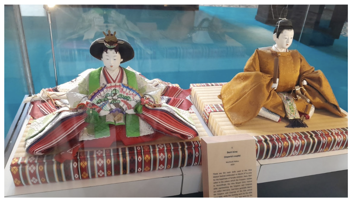
You will see Hina Ningyo of the Hina Matsuri festival at the center of the hall. They are called ‘Dairi-bina (Imperial couple)’ they are the main dolls used in the Hina Matsuri festival celebrated on March 3rd to pray for the happiness of girls.
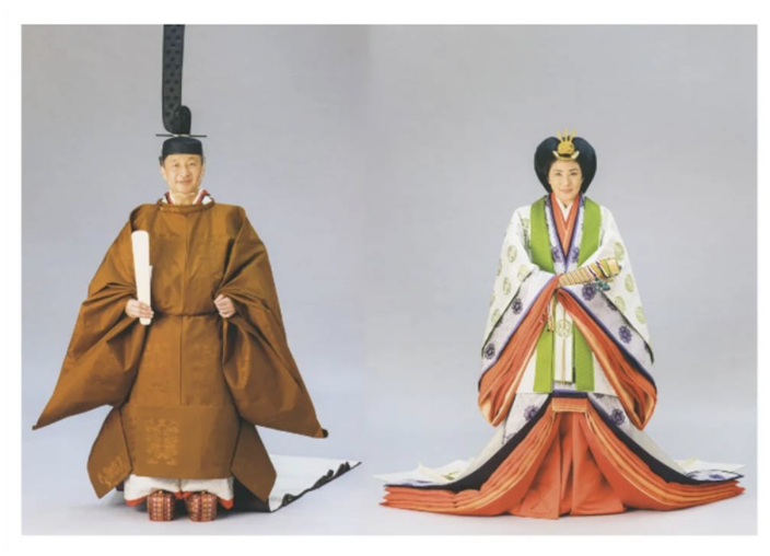
The clothing worn by the doll shown here is designed after that worn by the current Emperor and Emperess during a special imperial rites called the Enthronement Ceremony; Sokui no rei in 2019.
Many of you may have remembered the visit of the current Emperor when he was a prince to the National Museum in 2017.
The second section is ‘ningyo as fine art’, the evolution of the doll making techniques. Around from the 17th century, sculpting techniques, delicate colours, and finely produced clothing evolved so much.
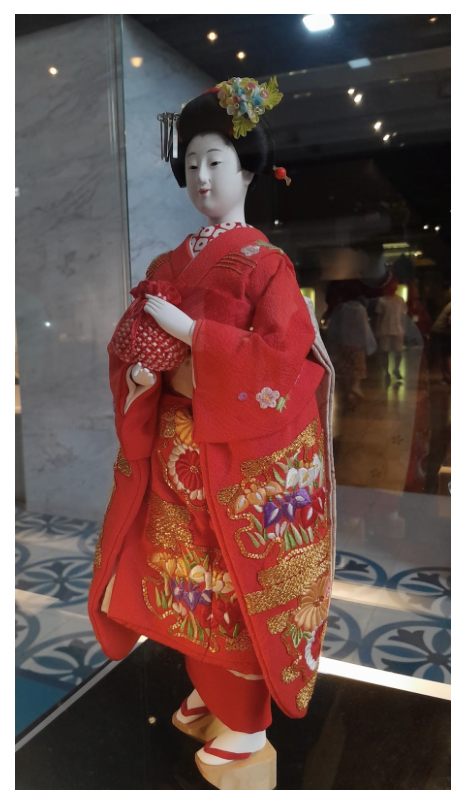
One of the great production is ‘Isho Ningyo; Maiko.’ Maiko is a young girl who performs professionally at traditional banquets in Kyoto.
The same weave, clothing and needlework is used with the same materials and methods to make the doll’s clothing as is used for actual clothes worn by Maiko.
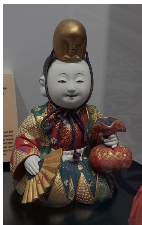
The other doll called ‘Saga Ningyo; Enmei fuku no Kami’, the God of happiness and longevity.
Fuku no Kami is a God who brings good fortune. In his left hand he holds a bag that is filled with all sorts of treasures.
Saga Ningyo are one of the most luxurious Japanese dolls from the Edo period(1603-1868). Its distinctive feature is the finely applied gold leaf and paint on the costumes.
The third section is ‘ningyo as folk art’, featuring traditional dolls from all over Japan.
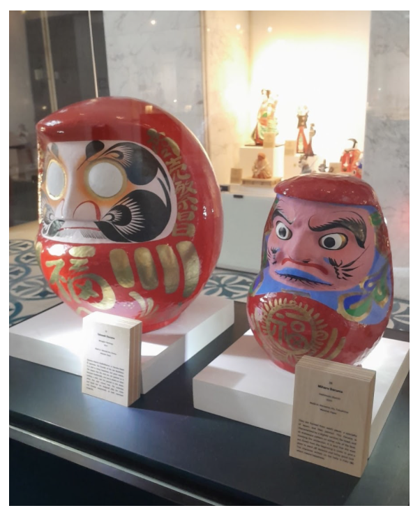
One of the most eye-catching dolls is the bright red, ball-like round doll Daruma.
The Daruma is a traditional Japanese doll that has been worshipped in Japan for centuries as a symbol of luck, success, and perseverance.
If the Daruma is said to bring good luck, how do we make use of it?
In fact, both eyes of the Daruma are empty when purchased.
After purchase, one eye is painted black when a wish is made. When this wish comes true or a goal is achieved, the other eye can be painted as well.
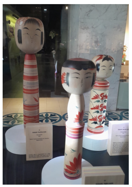
Similar to Darumas, the Kokeshi is a doll with no arms or legs, sold as a souvenir at hot spring resorts in the Tohoku region.
In some regions, it is believed that kokeshi dolls were created as a good-luck talisman to wish for the birth and healthy growth of a child.
Finally, the last section introduces the spread of Ningyo culture.
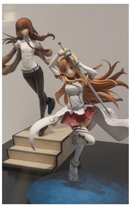
The reappraisal of dolls as art in modern times drove the emergence of many talented doll creators as works of art. As such, Japan’s doll culture further gave rise to the creation of collector figures which are popular throughout the world today.
Collector figures represent popular characters from games and animation. It is actually very difficult to recreate the 2D characters into 3D in a way that satisfies the expectations of the fans.
Come to the museum if you would like to know more about Japan’s Doll! There are many beautiful dolls for you to see and learn about.
It will surely be an enjoyable time for you.
>More videos from Japan Foundation (Japanese/English)
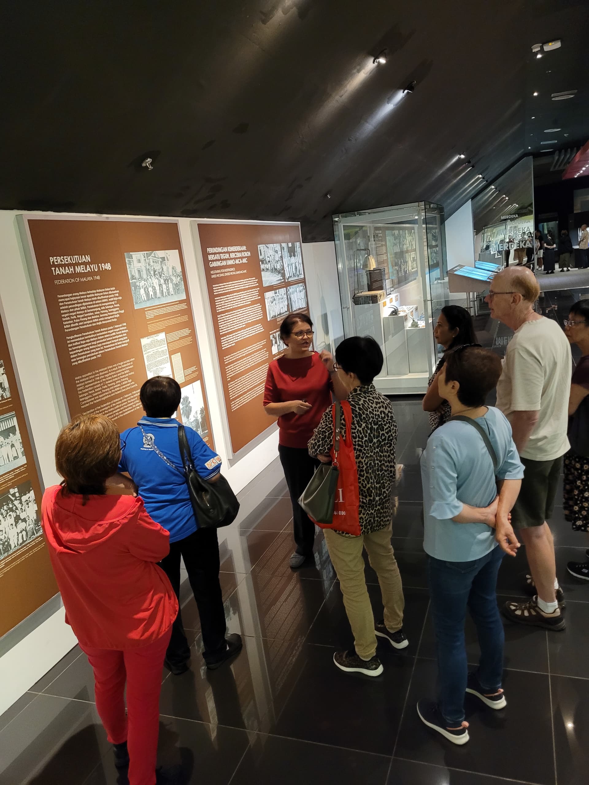
>The staff and curator of the National Museum gave an overvies to volunteer guids.
A MV FOCUS TALK by Professor Daniel Perret (27th May 2024) By Hani Kamal
Professor Daniel Perret, the head of the French School of Asian Studies at the Faculty of Arts and Social Sciences, History Department, Universiti Malaya, is currently serving as a visiting professor at the same institution. His research specialises in the history of epigraphy and archaeology in proto-urban sites throughout Southeast Asia. His presentation, titled “New Research into the History of the Patani Sultanate in the 16th-17th Centuries,” focused on investigating the historical aspects of Patani.
Perret and Jorge Santos recently conducted a translation of a substantial collection of articles sourced from European, Japanese, and Chinese historical records. These sources shed light on the extensive trade relationships established by European powers such as the Portuguese, Dutch, and British in Patani during the 16th and 17th centuries. Through their study “Patani Through Foreign Eyes: Sixteenth and Seventeenth Centuries,” published in 2022, Perret and Santos meticulously translated and re-analysed these foreign historical manuscripts detailing the dynamic events within the Patani Sultanate, particularly the reign of four successive queens.
Perret’s presentation emphasised the significance of combining physical evidence, such as monuments and artefacts, with information extracted from ancient manuscripts. These elements provide valuable insights into the events unfolding in the 16th and 17th centuries, showcasing Patani as a pivotal trading hub in the Eastern Seas under the influential rule of these queens. Examples of such artefacts include ancient royal tombstones such as Batu Acheh gravestones, a sketch of the old citadel and manuscripts documenting the legacy of the Patani queens.
Background of Patani
The word Patani originated from the Malay word “pantai ini” (this beach), and as mentioned in Hikayat Patani, it is where a white mouse deer was spotted. In the early days, Patani covered the entire Thai provinces of Patani, Yala, and Narathiwat and included parts of northern Kelantan in Malaysia. According to Hikayat Patani, which was recorded by various authors between 1690 and 1730, the early history of Patani must have been established in the early 2nd century when the strategic cape of Patani was sought after by ships travelling straight from the Gulf of Siam across from the Vietnamese point before going to the Malay Peninsula ports. According to Teeuw and Wyatt’s translated version of the “Hikayat Patani: The Story of Patani”, published in 1970, Patani was believed to be Langkasuka (208BC), situated in a very strategic location geographically ideal for a very complex Asian trade system. Professor Wheatley, in his book TheGolden Khersonese, A Study of Asian Historical Geography, concludes that Langkasuka transitioned into Kota Mahligai (now Yarang). But it became almost non-existent when the Srivijaya empire became powerful in the 8th and 9th centuries, dominating the Malay Peninsula. There were major power struggles among the Siamese, Khmer Empire, the Burmese Mon/Pagan Empire, the Cholas, and the Javanese in Southeast Asia during the same period. It is not clear as to when Kota Mahligai became Patani before 1500. However, three main themes emerged in the literary sources on Patani: Siamese influence, its conversion to Islam and its economic rise. (Bougas, 1990: Pg 114)
The peak period in Patani’s history is typically identified as the 16th and 17th centuries. However, by the latter part of the 17th century, the influences of Siamese Sukhothai and Ayuthaya began to dominate the region. In 1902, Siam further weakened Patani’s authority by dividing it into seven districts. The Treaty of Bangkok in early 1909 officially acknowledged Siam’s sovereignty over all the northern Malay territories, thus sealing the fate of Patani ever merging with the peninsula Malay states. Consequently, the Sultanate of Patani was dissolved, and its heir resided in exile in Kelantan. Following World War II, the Treaty of Songkhla in 1949 solidified the inclusion of Patani and the other northern Malay states into Thailand. The ongoing conflict and struggle for independence in Patani persist to this day amid continuing disputes.
The organisation of the Patani capital in early 17th CE
No maps portraying Patani during the 16th and 17th centuries have been discovered. The sole visual representation from that era is a depiction of the city, displayed in Figure 1, which was crafted by Jacob van Neck during his visit to Patani. An intriguing account from 1678 suggests that two trading officers from the British East India Company voyaged to Patani specifically to procure this city map, subsequently dispatching it to their office in Ayutthaya. Regrettably, Perret noted the absence of this document in the British Archives.
The illustration or sketch of the Patani capital, featured in Figure 1, offers a broad overview of the city during the 16th century. Jacob van Neck’s rendering highlights key locales such as the palace, the citadel, various town districts, the merchants’ quarters, and the harbour. This visual portrayal of the Patani capital’s layout is derived from on-site surveys, oral traditions and written accounts documented by diverse sources, including the Malay, Dutch, Portuguese, British, Japanese, and Chinese. Based on field data, it is inferred that this depiction dates back no further than 1584, a pivotal year marking the ascension of the first queen.
In Figure 1, Panarican—which appears eight times in the rutter—or “Penarekan” in Malay, denotes the dragging of boats across the river. “Tanjung Lulo”, appearing seven times in the rutter, is described as a headland on the sandy coastline with two bastions, including the largest in the city and its main gate. Tanjung Lulo is certainly the Tanjung Lulup mentioned once in the Hikayat Patani. Kuala Baca, a sandy beach area, was a town in Patani—it is the “Kuala Becha” mentioned in Hikayat Patani, as well as Dutch and Portuguese sources. On the west coast of the citadel, Garzen, which is frequently mentioned, is likely “Kerisik”, meaning coarse sand. This location fits well with the current location of Ban Kru Se (Kerisik). The “PINTU GARBA” mentioned is the Pintu Gerbang (main gate) in Hikayat Patani, large enough for elephants to pass through, also referred to as Pintu Besar (Big Gate) at the west of the Citadel. Kuala Saba (river mouth of Saba River), north of Panarican, has disappeared in the last four centuries.
Fig. 1. Sketch map of the city of Patani (late sixteenth – early seventeenth centuries) (adapted from Perret et al. 2004).
Portuguese sources—recounting a Portuguese attack on Patani in 1524—recorded Chinese living in brick houses in Patani. Dutch sources cite that Dutch lodges were built with bricks and that the English and Dutch lodged near the bay. The rutter also described the city as having a defence system that served as a channel for communication. According to the sources, the citadel walls were about eleven feet high and seemingly had a very imposing fort. Foreign sources also noted the formidable size of a cannon placed near the Pintu Gerbang. The royal family and Orang Kaya lived within the citadel. A small mosque was also located near the citadel. Salt pans, where salt was produced, were situated north of the citadel.
Similar sources also mentioned how the palace walls were adorned with gilded panels and other wood carvings. This is probably the earliest mention of woodcarving in the northeast state of the Malay Peninsula. The balairung (main royal hall) was described as abundantly decorated with gilded material and velvet-trimmed dais, and the queen sat by a large gilded window. A royal graveyard is also mentioned, and, based on oral tradition, the first Sultan of Patani could have been buried there. The tombstone could have been moved out of the city.
Unfortunately, the city was destroyed by fire four times between 1524 and 1613. By 1786, the Siamese had destroyed the entire city in retaliation to Patani’s assertion of independence.
Ancient Islamic Tombstones
Perret divided the tombstones he found in Patani into three styles: Batu Acheh, Batu Patani Brunei and Bai Sema.
The Batu Acheh tombstones, found across the Malay world, offer a unique insight into the region’s Islamic history. Characterised by sophistication and widespread distribution, these tombstones hold rich epigraphical data. Originating possibly in the 15th century around Pasai, these sandstone monuments signified a departure from local traditions. Although sharing similarities with architectural styles from Central Java and Siamese funerary monuments, batu Acheh was primarily reserved for sultans, high-ranking individuals, their relatives, and possibly affluent merchants. Despite a decline in the 18th and 19th centuries, a resurgence of batu Acheh can still be observed in regions like north Sumatra (Barus), Kedah, Pahang, and Penang.
Batu Acheh tombstones are generally made of sandstone, granites, quartz, river pebbles, marble, cement and wood. The types of material used for the tombstones also give an indication of the economic strength of the state—intricate quartz was used during the 17th century while wood and natural stone were used when the state was in decline. The Batu Acheh tombstones were imported from Acheh and had different shapes, motifs and Islamic Khad inscriptions. The grave of Raja Kuning (the last Queen of Patani) is marked with quartz markers found in Kubo’ Barahom.
Batu Patani Brunei (Figure 2) are tombstones brought in from Brunei. Brunei and Patani were trading partners between the 15th and 17th centuries. Two such grave sites were identified with Batu Patani Brunei in Kampung Parit and Kampung Pintu Gajah. The design was very specific to that found only in Patani and Brunei. It has Chinese motifs, such as clouds. One of the tombstones is believed to be that of the son of the founder of the Sultanate of Patani in the 15th century. It has an Arabic calligraphic inscription stating the son of the sultan on the south side and “Malik bin Mohamad” on the north direction. Unfortunately, no dates were found. Perret postulates that these tombstones could belong to the Brunei people who lived and were buried in Patani.
Fig. 2. Tombstone at Kuboʼ Barahom (D. Perret-EFEO, 1999)
Roeloefsz (1601-2) mentioned the existence of royal graves on the Seberang peninsula and this is the only source citing this interesting information. There were few tombstones found but no indication of a royal one. Ludvik Kalus (2004: 193-206).cited that there were two tombstones found and one of them believed to be the grave of the first Sultan of Patani (Fig.2).
According to oral tradition, Raja Ijau’s tombstone was made in the Bai Sema style (Figure 3), which is heavily influenced by Thai-Buddhist engravings. Originating from India, the Bai Sema designs resemble the Kala-Makara design, which is commonly found in the entrances of temples in Thailand and India. This style may have reached Patani from Trowulan, Surabaya. In Patani, Bai Sema tombstones are very rare.
Fig. 3 Raja Ijau Bai Sema Tombstone (Bougas: Pg 39)
Queen of Patani “The Rainbow Queens”
Female Rulers in the Malay World
When James Brooke visited the Bugis state of Waco, Brooke observed that six out of the eight prominent chiefs were female (Brooke, 1848 I, 74-5). In Islamic Southeast Asia, the presence of female rulers appeared to be a common occurrence. Notably, female Muslim rulers were intricately connected to the realm of commercial trading. Throughout the 15th to 17th centuries, women in these regions played a significant role in engaging in trade activities. For instance, Pasai, the first Muslim state in Southeast Asia, had two queens during its prosperous trading era (1405-1434). Similarly, Japara in North Java emerged as a key naval and commercial hub under the rule of its female queen, Kali Nyamt, in the 16th century.
“Similarly, the women rulers of the diamond-exporting centre of Sukadana in Southwest Borneo (c. 1608-22), pepper-rich Jambi in East Sumatra (163~. 1655), and the sandalwood base of Solor, to the East of Flores (c. 1650-70), were on the throne during the brief period these states were important commercial centres.” (Reid, 2020, Pg 641)
In her research on “Ratu Acheh,” Sher Banu explored the lives of the four Queens of Acheh in the 17th century. The first queen, Sultanah Safiatuddin (1612-1675), took the throne following the death of her husband, Sultan Iskandar Muda. She was succeeded by her daughter, and four Acheh Queens ruled the kingdom for sixty years.
Similarly, a comparable scenario unfolded in Patani during the 16th and 17th centuries, with the kingdom being governed by four consecutive queens. Patani served as a significant trading post, particularly with China, during this period. The preference for female rulers stemmed from the cooperation of the Orang Kaya (male royal councillors and religious ulama) with the queens, recognising their adeptness as rulers with business acumen rather than because they were running out of males to inherit the thrones. During the reign of Raja Ijau:
“Patani the first queen has reigned very peaceably with her councillors … so that all the subjects consider her government better than that of the dead king. For all necessities are very cheap here now, whereas in the king’s time (so they say) they were dearer by half, because of the great exactions which then occurred.” (Van Neck, 1604:206)
Patani, under Raja Kuning, the Orang Kaya, paid less levies as Raja Kuning was a wealthy heiress and a capable businesswoman. The Orang Kaya saw how female rulers were more businesslike and profitable for themselves. They were also mild in ruling the states compared to male rulers.
Raja Ijau, the eldest daughter of Sultan Patik Siam, took power in Patani after the sudden deaths of many male family members. During her 32-year rule, Raja Ijau led an army against Pahang and defended Patani against Ayutthaya, fostering diplomatic relations and promoting culture and art. She is credited with the origins of the Mak Yong dance. Raja Biru continued her mother’s diplomatic legacy and was an adept mediator between the Dutch VOC and British EIC. Raja Ungu defied Siamese rule, aligning with Portugal, Pahang and Johor to repel a Siamese force and further solidify alliances through strategic marriages. Raja Kuning enhanced Patani’s economic prosperity and established it as a prosperous Malay trading post. Following her overthrow by a minister, she retired to Kuantan, Pahang, marking the end of female rule in Patani.
As outlined by Perret, the era of female rulers in Patani was characterised by a decrease in violent incidents and massacres within the royal families. This period was notably peaceful, fostering a sense of safety that encouraged traders to conduct business with relative security. However, following the reign of these queens, the Patani throne shifted to male lineages, possibly influenced by conservative factions aiming to enforce Islamic practices that restrict female leadership over men. The subsequent male rulers exhibited intense competition and a diminished focus on trade, leading to a decline in safety and profitability for Patani as a trading hub during their governance.
The Queens’ Title
Perret noted the Patani Queens used the Indian Sanskrit male title “raja” instead of the Islamic “sultanah” or the Malay “ratu.” Historical sources from Patani do not provide evidence of the title “Sultanah” being used. The discovery of a gold coin inscribed with the words “al-sultana-al muazam” (the great Sultanah) and “Khalada Mulkaha” (May God preserve her government) has led some to speculate that it may have been associated with one of the Patani Queens. Perret pointed out discrepancies between this coin’s inscription and those on coins issued by the Sultanah of Aceh, as well as the absence of coinage from the Queens of Sukadana and Jambi in the 17th century. He further questioned the authenticity of the claim that the Patani Queens ever adopted the Islamic title of Sultanah and pondered why there is a lack of mention in Malay sources regarding minted gold coins.
The Color Names
The Patani Queens were named after colours, and thus, the acronym ‘’Rainbow Queens of Patani’’ was coined by Teuuw and Wyatt. Some scholars likened it to how in Malay tradition, females were given names associated with colours, or that green is an Islamic colour, and Raja Kuning (yellow) had yellow skin and was given the colour yellow. Jocelin de Jong’s documentation in 1961 highlighted the prevalent use of colour names among Malays. For instance, titles like Tun Hitam or Tun Putih were commonly bestowed upon Malay women in Sejarah Melayu.
Professor Perret suggested that the tradition of using names based on colour could be rooted in religious or traditional beliefs associated with auspicious symbolism. For example, the Katika Lima system—where a day is divided into five periods, and each period is associated with a colour—is directly related to a Hindu god. Each colour represents the time of birth of the queen. A second possibility is that the colour was related to the day/time of birth, like the zodiac. It could also be related to Buddhist influence. In Buddhism, each cardinal points are related to a colour as also with the Chinese belief. It is also believed that names with colours are linked to the traditional culture of Chinese zodiac practises:
“The centre of the system is Vairocana, associated with the white colour, while interestingly, the colours of the four cardinal points correspond to the names of the four queens: North is associated with Amoghasiddi and the green colour; East is associated with Akṣobhya and the blue colour; West is associated with Amitābha and the red colour; South is associated with Ratnasaṃbhawa and the yellow colour. Moreover, the colours are associated with the same cardinal points in traditional Chinese culture.” (Damais 1969: 83-84: extracted from Perret’s article, 2022)
Perret also found through the sources that the use of colours for the queens was only used within the palace, and as for the foreigners, the queens were referred to merely as “old queen” or “young queen.” These colour names are definitely not by chance but linked with greatness for the royal household, or they were intentionally meant to legitimise the queen’s sovereignty in the state of Patani.
Power Sharing
Perret also noted the unique power-sharing practised by the four queens. The old queen is assisted by a young queen who acts as a regent and is the next in line. This power-sharing system seems to have worked for the Queens, as during their reigns, Patani flourished economically and politically.
Chronology of the Queens
Perret suggested that the dates of the Patani queens require further investigation since dates were never mentioned in Malay writings (namely Hikayat Patani, Sejarah Patani, Syair Patani and Kelantan). However, when various sources written in foreign records surfaced, this suggested that the periods or dates as deduced in Hikayat Patani were different and required re-examination. Some foreign sources cited Christian years while others utilised the Muslim calendar, and confusion emerged.
More confusion arose when understudying the Patani sources as the use of colours for the Queens was only for the internal royal court; thus, for foreigners, it’s either the Old Queen or Young Queen, as names of the queens were never cited in any foreign sources. It was quite a task to identify the period of rule of the Queens also because the Malay sources did not include dates/periods. However, a letter surfaced, the correspondence between one of the queens and the King of Portugal dated 31 March 1637. This threw new light into the confusion of the chronology of the queens. According to Perret, the dates of ruling for the queens require some rearrangement. Perret summed up these reigns as follows:
Raja Ijau (Old Queen: r. 1584 – 28/08/1616; d. 28/08/1616)
Raja Biru (Young Queen: r. ≤ 1601 – 28/08/1616; Old Queen: r. ca. 09/1616 – ca. 03/1636; d. ca. 03/1636)
Raja Ungu (Young Queen: r. ≤ 1629 – 1634; d. between 1636 and 1638)
Raja Kuning (Young Queen: r. end of 1634 or 01/1635 – ca. 03/1636; Old Queen: r. ca. 03/1636 – ≥ 1642; d. ≥ 1642)
Fig. 4 Chronology of Patani Rulers
Patani’s Emergence as a Trading Hub
Following Malacca’s fall to the Portuguese in 1511, Patani emerged as a lucrative alternative trading centre. It was also a strategic port for sailors travelling from China to Java to stop at Patani for shelter, repairs and trading. The region attracted a diverse array of merchants, including Chinese, Malay, Siamese, Persians, Indians, Arabs, Portuguese, Japanese, Dutch, and English traders. The peak of Patani’s trading significance is often associated with the reign of Raja Ijau. Chinese entrepreneurs played a pivotal role in Patani’s rise as they exchanged goods like porcelain, silk, and lacquer for cloves, nutmeg, sandalwood, and pepper sourced from the spice islands.
Historical records indicate that Patani’s influence as a trade hub extended beyond local waters. Patani junks engaged in trade with Banda for nutmeg and mace as early as 1526, while Chinese junks from Fujian frequented Southeast Asian ports like Pahang and Patani in the late 1520s. Indian traders also participated in the exchange, offering textiles in return for pepper, gold, and food items. Chinese and Indian goods brought to Patani were further distributed by Malay traders across Thailand and the Indonesian archipelago. Additionally, the Kingdom of Ryukyu served as a crucial intermediary linking China, Japan, and Patani, facilitating trade growth in the region.
“Like all major coastal trading places at the time in Southeast Asia, Patani was home to a cosmopolitan population. It is thus reasonable to suggest that some twenty languages were in daily or occasional use in Patani during the sixteenth and seventeenth centuries. (Perret, 2022: Pg 143)
However, Perret summarised that Patani’s position as a trading hub declined by the mid-17th century as trade restrictions limited the movement of Japanese traders and hindered Chinese-Japanese trade interactions. Furthermore, shifts in market demands led to a decreased interest in local spices like pepper and a decline in the popularity of Indian cotton materials. Patani struggled to adapt to changing trade dynamics during this period, failing to sustain its earlier prosperity and meet evolving commercial challenges.
Conclusion
Perret and Santos’ examination of foreign sources proved useful in shedding light on how Patani emerged as a significant state during the 16th and 17th centuries. These sources offered insights into the queens’ chronology, Patani’s administrative system, the layout of the old city, and its economic, political, and social structures during that era.
Determining the precise timeline of the queens proved challenging due to discrepancies in various historical texts. Foreign sources often referred to the queens generically as ‘old queen’ or ‘young queen’ and not by their names. Perret’s meticulous analysis allowed for the reorganisation of the queens’ chronology based on available manuscripts.
Once again, foreign sources are abundant and detailed in their description of the city’s location and design, but they are also confusing or, on many occasions, contradictory. Perhaps as suggested by Bougas, where only by excavation of the city/citadel location, artefacts excavated will provide evidence to support the history of Patani. The old city has never been excavated, nor have any archaeological methods been used to verify the sites and compare them with historical narratives.
The extent of real power wielded by the Patani Queens within the kingdom remains a subject of inquiry. Questions arise regarding whether the queens held substantive authority or if the influence lay with other figures like the Orang Kaya, councillors, Islamic leaders, Chinese merchants, or Javanese traders. While Malay sources like Hikayat Patani and Syair Patani remain silent on the queens’ authority, foreign accounts highlight their roles in trade management.
It is possible that the real power was with the court councillors, while the queens handled foreign traders. But then again, the four female rulers reigned for almost a century. It could not have lasted 100 years if it had not been for their skilful manoeuvring of the Orang Kaya and social-economic skills when dealing with foreign merchants.
Perret and the foreign sources may not have found the answers to establish the use of the queens’ titles. However, these sources are able to clarify many questions concerning the presence of female rulers in Patani. They can probably inspire the people of Patani today.
Fig. 5. Salt ponds, Ban Pa Re (D. Perret, June 1997)
References:
MV Focus Talk by Professor Daniel Perret on 27th May 2024, MV Room, JMM.
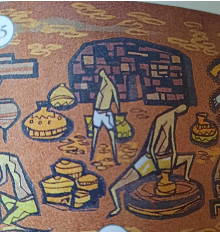
The National Museum of Kuala Lumpur’s west wall isn’t just a surface; it’s a window into Malaysian craftsmanship. Artist Cheong Lai Tong’s iconic mural, “Malayan Crafts and Craftsmen,” goes beyond individual figures. It’s a thematic map, inviting us to explore the core elements that bind these crafts together: earth, fibres, metals, textiles, and wood.
Through this exploration, we’ll unlock a conversation between nature and human ingenuity.
This bi-weekly series will feature seven articles, each focusing on a specific element. We’ll appreciate the mural’s artistry while discovering corresponding collections housed within the museum’s walls.
A Legacy from Earth
The story of Malaysian pottery is a fascinating journey that begins with the earth itself. As early as the Neolithic period, when nomadic hunter-gatherers transitioned to a more agricultural lifestyle, the need for storage and transport vessels arose.
A key element in this tale is clay. Its remarkable malleability allowed these early artisans to shape the earth with their hands, creating vessels that could hold their form after drying and transform into permanent fixtures through the application of fire.
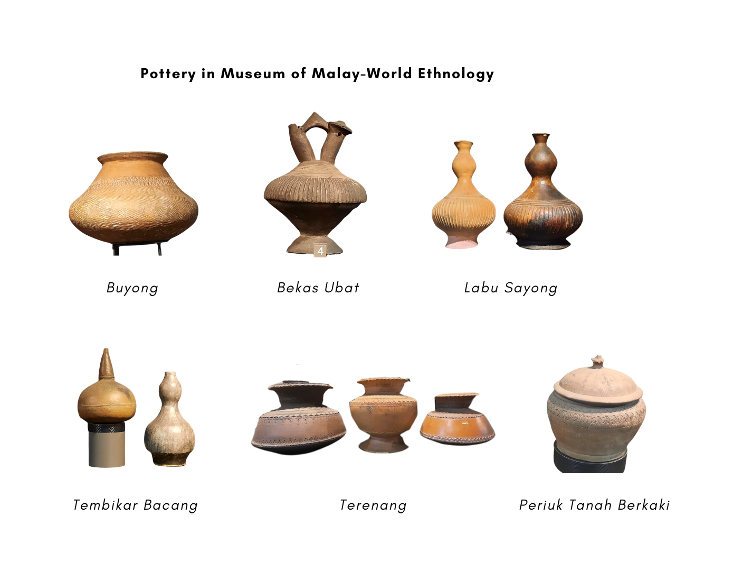
The museum’s collection reveals the multifaceted nature of Malaysian pottery. It’s a story not just of form and function but also of cultural heritage, technological advancements, and artistic expression. It facilitated early barter trade systems, as these functional objects became valuable commodities exchanged across the region.
Location
Pottery type
Description
Museum of Malay Ethnography
Bacong
Large, wide-mouthed jars traditionally used for storing water and rice.
Labu Sayong
Gourd-shaped water bottles made from terracotta feature ribbed bodies and are often adorned with incised geometric patterns. Traditionally, they were hand-moulded without the use of a potter’s wheel.
Buyong
Large, wide-bodied water containers with a narrow neck, often decorated with floral motifs.
Bekas Ubat (Medicine Container)
Small, lidded containers used for storing traditional Malay medicines. This double-spouted kendi is a water container used in Southeast Asian rituals. The name “kendi” comes from the Malay term derived from the Sanskrit word “kundika,” meaning “water vessel.” Unlike most kendi, which lack handles, this specific example features a small handle connecting the two spouts. Their use was prominent in important ceremonies like weddings and funerals. Water from a kendi would be sprinkled during these rituals.
Terenang
Crafted from earthenware, these cooking pots feature a rounded bottom and a wide rim. Decorated with stamped and incised geometric motifs around the body and rim. Terenang’s name derives from the word “tunang,” signifying its original role as a container for engagement rings in Pahang. Notably, Terenang is one of the few types of Tembeling pottery, and the “tali air” refers to the border separating each section of this potteryware.
Periuk Tanah Berkaki (Legged / Footed Claypot)
Clay cooking pot raised on three or four legs, designed for even heat distribution.
Photo credit: Manjeet Dhillon
Location
Pottery type
Description
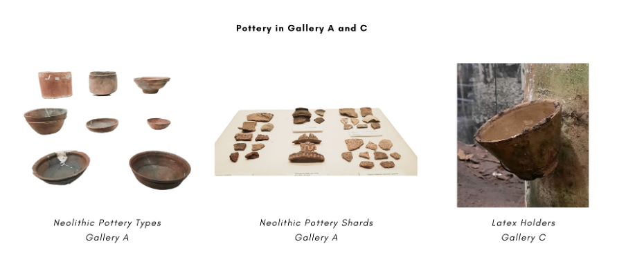
Gallery A
Neolithic Pottery
The earliest forms of Malaysian pottery date back thousands of years. Includes utilitarian vessels, shards with plain, tri-colour, or patterned decorations, unearthed from archaeological sites like Gunung Cha in Kelantan.
Gallery C
Ceramic Latex Holder
Container crafted from glazed ceramic, specifically designed to hold latex collected from rubber trees.
Photo credit: Manjeet Dhillon
Gallery A: Burial Vitrine
While these clay jars in Gallery A’s burial vitrine might seem like local creations, they were transported to Borneo through maritime trade routes, highlighting the interconnectedness of different cultures in the region.
These impressive clay jars, known as Martaban jars, were prized by the Iban people for both practical and symbolic reasons. They served not only as storage containers but also as markers of wealth and status. Interestingly, these jars, also called “tajau” by the Dayak people of Kalimantan, weren’t produced locally.
Some Martaban jars even feature moulded dragons on their sides, earning them the name “dragon jars.”
[Historical Connection]: Martaban is the name of a port on the east side of the Irrawaddy Delta in present-day Myanmar. This port became well known for its trade in huge storage jars. The association was so strong that “Martaban” eventually became synonymous with the name of the jars themselves.
[Cultural Insight]: Traditionally, potters evaluated the quality of Martaban jars by their sound. When struck with the hand or a wooden stick, a high-quality jar would produce a clear, ringing tone. This indicated the jar’s strength, density, and ability to properly store valuable goods. Hence, Martaban jars are often referred to as “talking jars.”
[Cultural Insight]: Among the indigenous communities in Sarawak, Martaban jars also serve as funerary equipment. Within a family home, an upside-down jar might stand out conspicuously. This signifies that an older woman has reserved it for her own burial, indicating her wish that it not be used for its more common purpose of fermenting wine. For further reading, you can explore Trade Objects by Lucas Chin.
With the museum’s collection as our guide, let’s explore some of the broader threads that define Malaysian pottery:
1- Sarawak Pottery: Here, we find two distinct pottery traditions.
Chinese potters near Kuching and Sibu craft stoneware jars (tempayan) in hues of brown, green, and blue with embossed and incised patterns. The pottery industry in Kuching nowadays can be found clustered together on Penrissen Road, Kuching. You can watch a video of Sarawak pottery.
In contrast, the Iban, Murut, and Kelabit communities produce a distinct type of pottery: simple and fired at a low temperature. This pottery is often used in their weaving ceremonies. Interestingly, the style of this pottery bears a striking resemblance to Neolithic pottery found in Sarawak, hinting at a long-standing tradition that may stretch back thousands of years.
Image source: Borneo Post Online
A potter’s toolkit, crafted from natural materials, is laid out here. From left to right:
i) Penempa: a carving tool carved from belian, a strong and durable ironwood.
ii) Batu segala or batu bulat: smooth stones used for shaping the clay.
iii) Simpai and bemban: these tools are made from rattan. The simpai is used for shaping or coiling the clay, while the bemban functions as a stand for the pots.
2- Malay Pottery: Characterised by four distinct forms:
3- Chinese Dragon Kiln Pottery: Over a century ago, Teochew immigrants brought a symbol of Chinese ingenuity – the long, roofed kilns. Fueled by the rubber boom’s demand for latex cups, families from Swatow (Guangdong, China) established clusters like those north of Ipoh near clay deposits. Today, these kilns have shifted their focus, primarily producing stoneware flower pots and water jars for a global audience. You can watch a video of these kilns in action here.
4- Indian Pottery: In Kampung Kedah (Parit Buntar) and Batu Dua (Kuala Selangor), potteries specialise in low-fired terracotta ware. These items are primarily used for religious and ceremonial purposes, such as oil burners and incense holders. One example of such pottery is the pannai pot, a traditional cooking vessel favoured for preparing Pongal, a dish of rice boiled in milk and raw sugar cane.
Pots, typically shaped like belanga or periuk, are decorated with simple stamped designs that reflect their utilitarian purpose. You can watch a video to see the pot-making process in Kuala Selangor.
photo credit : Manjeet Dhillon
Figures on the museum’s mural:
A central figure in the museum’s mural is a potter, busily working amidst a display of finished and in-progress earthenware forms. In the background, a kiln suggests the process of firing these ceramic creations.
From the Neolithic era to the present day, earth has served as a crucial element in shaping Malaysian crafts. As we move through the museum’s collection, we’ll discover how other elements – fibres, wood, textiles, and metals – contribute to this remarkable story of human ingenuity and artistic expression. In our next series, we’ll learn more about crafts made from Malaysian fibres, where bamboo, rattan, and pandanus leaves take centre stage.
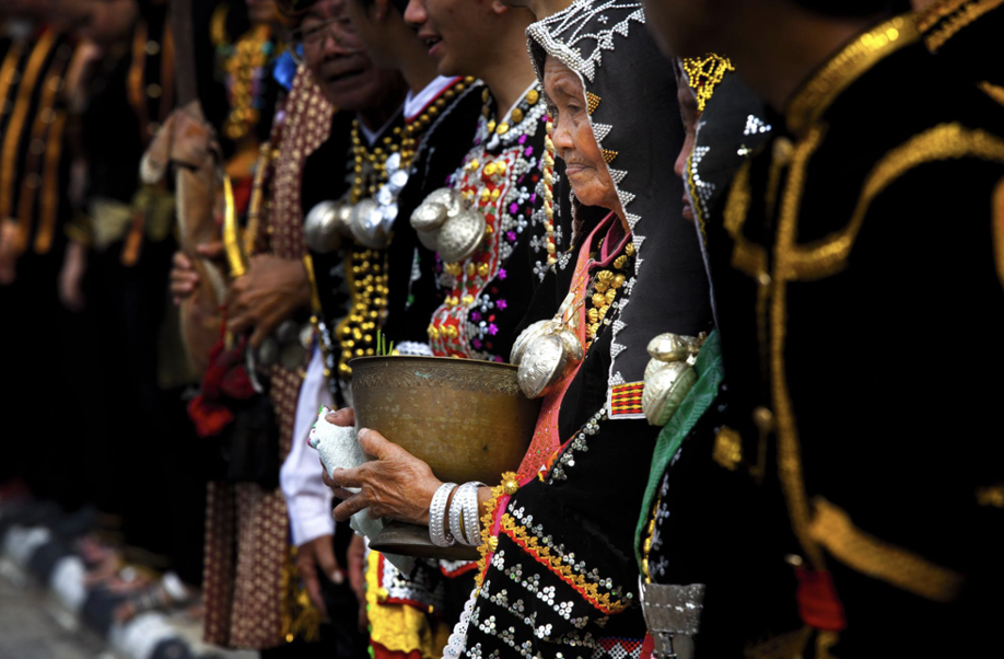
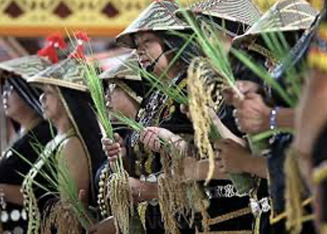
Sabah’s annual harvest festival, Tadau Kaamatan, is a celebration deeply rooted in the Kadazandusun community’s cultural heritage. Centred around the rice harvest, the month-long event features rituals, traditions, and myths that highlight the grain’s significance. These myths, though diverse in origin, often share a unifying theme: the sacrifice of a beloved female relative.
Historically and traditionally, Kaamatan was held at the first sighting of the full moon following the harvesting season. This period, known as “tawang” (literally meaning “full moon”), signified the perfect timing for the festival. The month-long celebration culminates on May 30th and 31st, highlighting the profound significance of rice for the indigenous communities of Sabah.
Credit: Sabah Tourism / Tsen Lip Kai
Rooted in Legend
The roots of Kaamatan stretch back centuries, intertwined with the Kadazan legend of Huminodun. This tale tells of a time when harmony reigned between a benevolent god, Kinoingan, and his people on earth. However, Kinoingan’s son, Ponompulan, disrupted this peace, leading to his banishment to Kolungkud, or the underworld, and a series of devastating plagues upon humanity.
Credit: Sunduan Do Huminodun (The Spirit of Huminodun) by Pangrok Sulap
Faced with drought and famine, Huminodun, Kinoingan’s daughter, made the ultimate sacrifice, she offered her own body to nourish the people. Through Huminodun’s sacrifice, her body transformed into various food sources: rice from her flesh, coconuts from her head, tapioca from her bones, ginger from her toes, maize from her teeth, and yams from her knees. and a variety of other edible plants sprang forth, ensuring the community’s survival.
This bountiful harvest marked a turning point, and Kaamatan became an annual celebration to honour Huminodun’s sacrifice and express gratitude for the blessings of the land.
While the details differ, a similar theme of sacrifice for the community’s well-being emerges in the Murut (tagal) genesis myth of siblings, Olomor and Sulia. In this narrative, Olomor sacrifices his sister Sulia, following a vision during their rice field clearing. Seven days later, various plants sprout, including rice, highlighting the theme of sacrifice for the community’s well-being.
(While the details differ, a similar theme of sacrifice for the community’s well-being emerges in the Murut (Tagal) genesis myth of siblings, Olomor and Sulia. In this narrative, Olomor sacrifices his sister for the same purpose. As the story goes, Olomor and Sulia were clearing land to cultivate rice. Later that day, while resting, Olomor had a vision in which he saw Sulia being sacrificed to produce rice seedlings. Despite his guilt, he felt compelled to follow through with the vision. He brought Sulia to the clearing and killed her. Her body rolled on the ground, and her blood flowed to every corner of the cleared land. Seven days later, Olomor returned to find that various plants had sprouted, one of which was rice.)
Both Kadazan and Murut legends tell of sacrifices made for the community’s well-being. These stories highlight the deep respect these cultures have for the land and the rice harvest it provides.
A Journey of Rituals
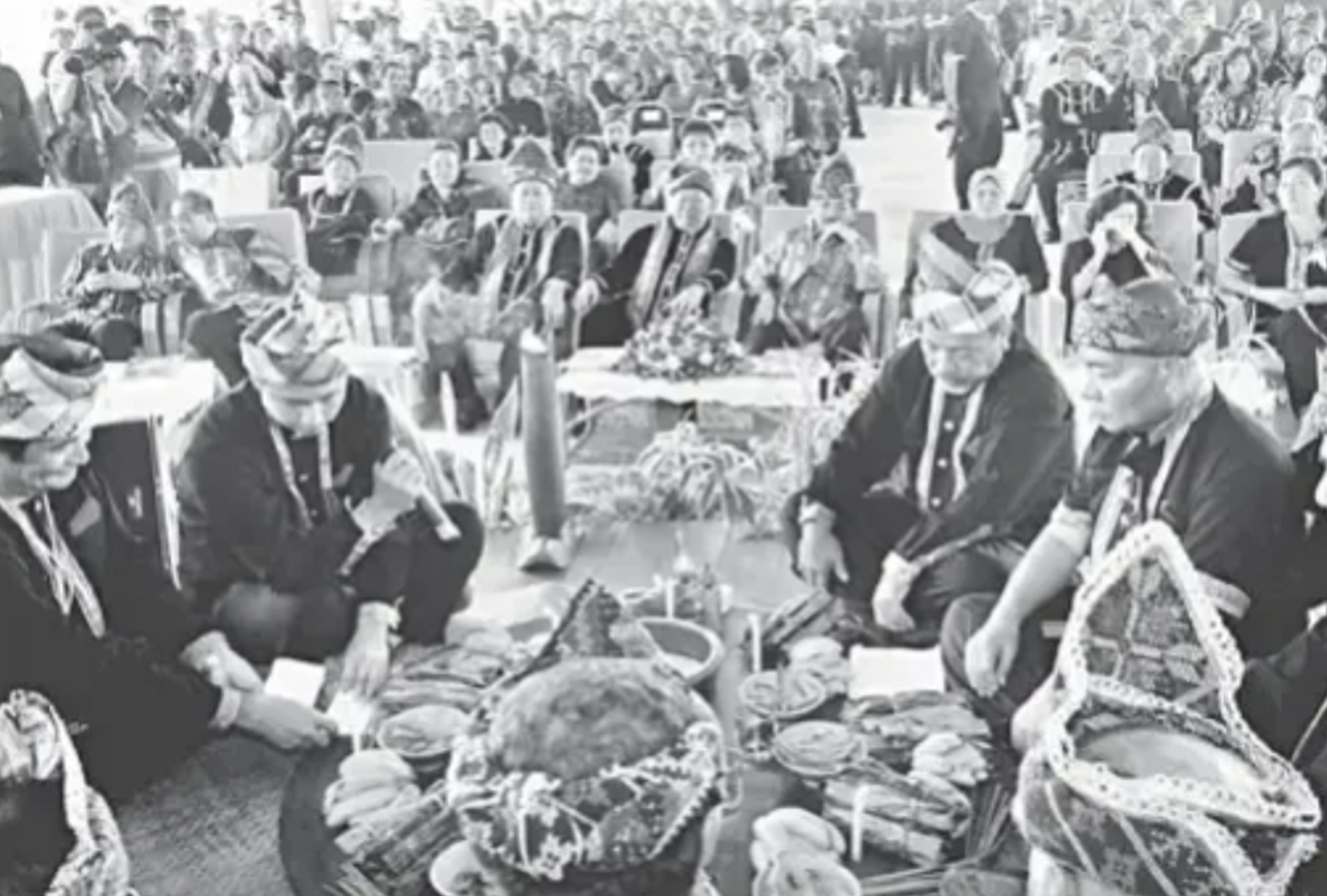
The heart of Tadau Kaamatan unfolds through a series of rituals performed by the Bobohizan, a traditional priest or priestess. The six distinct rituals described below are typical of the Kadazandusun community of the “tangara” in the Penampang-Papar area.
Kumogos: Before harvest, a Bobohizan (priest/priestess) chooses the seven best rice stalks. These are left scattered in the field to appease any spirits and promise an offering after harvest.
Kumotob: Following Kumogos, the Bobohizan selects the best unharvested rice stalks. These are tied together and stored in a tadang (rice basket) for next season’s planting.
Posisip: The Bobohizan carries seven tied rice stalks to the rice hut and inserts them into a bamboo pole kept in the tangkob (container) while chanting prayers for Bambaazon, the rice spirit, to stay and bless the harvest.
Poiib: the Bobohizan carefully pours rice into the tangkob within the hut. This continues until all the rice is transferred, accompanied by chants beseeching the rice spirits to watch over the stored harvest.
Magavau: The most significant ceremony, Magavau restores Bambaazon’s spirit and offers food as a gesture of respect.
Humabot: This final stage explodes with joyous celebrations, featuring traditional dances, sports competitions, and the crowning of the Unduk Ngadau, a maiden who embodies the spirit of Huminodun.
The Kadazandusun are not alone in celebrating this bountiful season. There are other indigenous communities that have each developed unique traditions to express gratitude for a bountiful crop and appease the spirits who ensure their success.
The names for the harvest festival vary across ethnicities. The Rungus call it “kokotual” and the Timugon Murut celebrate “orou napangaan nanantab.” While the festival’s core message of gratitude remains constant, the names and traditions vary across ethnicities. The Lotud Dusun of Tuaran focuses on intimate rituals with animal sacrifices and symbolic dances, while the Timugon Murut of Tenom holds a communal feast with “mansisia” celebrations. The Tagal Murut holds a lively seven-day celebration with activities like cockfighting and dancing. Meanwhile, The Rungus of Kudat perform rituals involving animal sacrifices and a “mongigol sumundai” dance throughout the night. Despite these ethnic variations, all celebrations share a common thread of thanksgiving and respect for the land.
A Celebration of Community
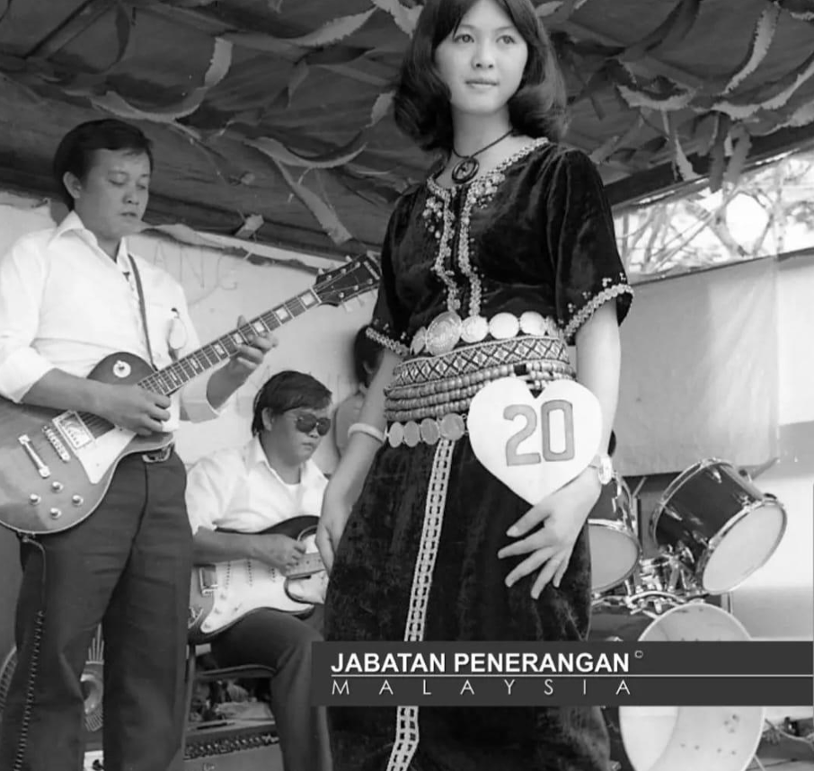
As Tadau Kaamatan reaches its peak, the Unduk Ngadau pageant takes centre stage. Held on May 31st, contestants from various districts embody the spirit and grace of Huminodun, the mythical figure who sacrificed herself for the harvest. Through their elegance and cultural knowledge, they compete to be crowned the Unduk Ngadau, literally meaning “the sun at its zenith—the brightest point of the day” in Kadazandusun.
While the Unduk Ngadau pageant captures the spotlight, Kaamatan also celebrates the rich musical heritage of the Kadazandusun people through a vibrant singing competition known as Sugandoi. The Sugandoi competition features age-group categories, ensuring traditional music resonates across generations.
Credit : Jabatan Penerangan Sabah
Fun Fact: The Spirit Behind the Song: Did you know Sugandoi has a fascinating history? For the KadazanDusun community, Sugandoi was once a “spirit” invoked by the Bobohizan (priestess) and housed in a large jar called a “Kakanan” by the Kadazan Tangaah tribe. This spirit was believed to watch over families and bring good fortune through a ceremony called “Moginakan.” During this ritual, the Bobohizan would chant incantations called “Monugandoi,” which praised the creator (Kinoingan) and the spirit of Sugandoi. These chants laid the foundation for the modern Sugandoi singing competition. No wonder the name stuck!
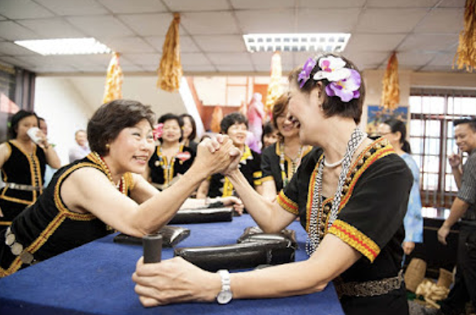
Adding to the atmosphere are traditional games and competitions. From displays of strength in arm wrestling (mipulos) and knuckle wrestling (mipadsa) to showcasing skills in blow piping (monopuk) and catapulting (momolositik), these games provide a fun and interactive way to experience Kadazan Dusun culture. Teamwork is tested in tug-of-war (migayat lukug), while balance and agility are on display during bamboo stilt walking (rampanau).
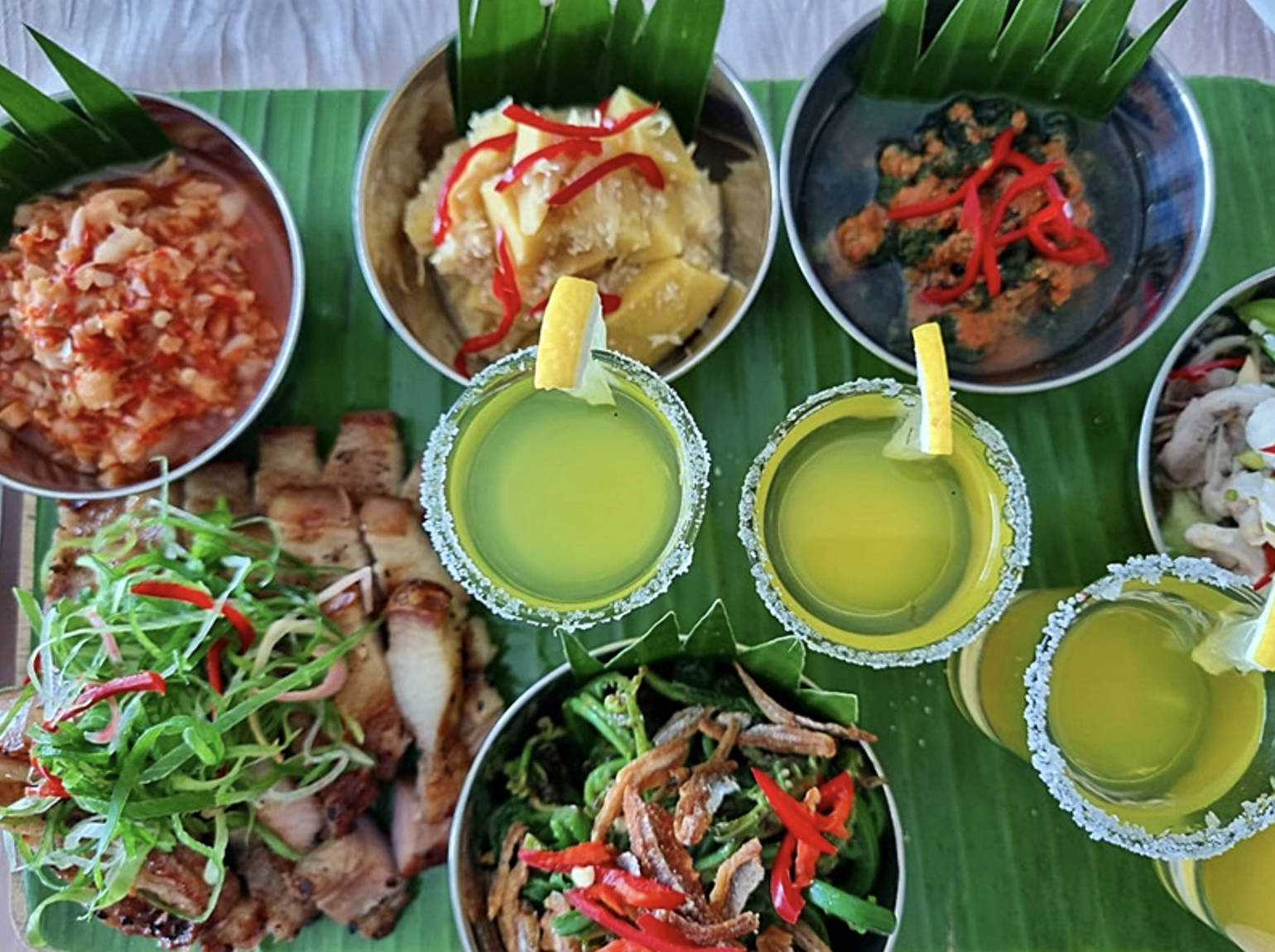
No festival is complete without a feast for the senses, and Tadau Kaamatan doesn’t disappoint. From the tangy zing of Hinava (raw fish) to the textures of Butod (sago grubs), the flavours of Pinasakan (braised fish), the tart tang of ambangan (wild mango), and the earthy warmth of Tuhau (wild ginger), Tadau Kaamatan is a feast for the senses. Lihing, a rice wine made from fermented rice and stored in clay jars, adds a special touch to the celebratory spirit.
Tadau Kaamatan is more than just a harvest festival; it’s a cornerstone of Kadazandusun identity and other ethnicities in Sabah. These age-old traditions, a vital link to the past, ensure their shared cultural heritage continues to thrive for generations to come. It’s a celebration of the land, its bounty, and the enduring spirit of these communities.
Barlocco F., 2011. A Tale of Two Celebrations: The Pesta Kaamatan as a Site of Struggle between a Minority and the State in Sabah, East Malaysia. Asian Journal of Social Science from https://www.jstor.org/stable/43497845?seq=1
As visitors walk through the halls of the museum, they become enveloped in a symphony of sounds that pulse with centuries’ past. Each artefact and diorama emit a vibration, a sensation, telling stories of triumph and defeat, rituals and practices, layering and blending of cultures. Every journey is the start of a story… and what better way to pay homage to our stories than through the art of listening.
Whispers of Stones and Ancient Artworks
The museum walls hold a world of ancient mysteries and forgotten civilizations, with stone tools and ancient artworks offering glimpses into the lives of our ancestors. Stones, once raw and jagged were skillfully crushed, smoothened, sharpened and refined, like a Chef’s set of knives that crush, cut and slice.
Rock art, that adorn cave walls speak of a time when black charcoal and red hematite were splashed across limestone canvas, like a mural, capturing and documenting rituals and ceremonies. Each whispered their stories, the heart-beat of the people.
Larger rocks were artistically sculpted into stone tablets, makaras and statues of beauty and grace. Towering megaliths, inscribed with salient iconography stand as silent custodians, bearing witness to the diverse layering yet harmonious practices that bound humanity.
The sounds of diversity and harmony
Dong Son Drum and Bell
The Dong Son bronze drum and bell, found in various states of the Peninsular, bear motifs similar to those from Dong Son, North Vietnam, indicating long-distance land trade in South East Asia.
The Dong Son drum, a sacred instrument, was used during harvest festivals, weddings and burials to call upon nature and ancestral spirits. When struck, it produced a powerful, resonating vibration that filled the air.
The bell, likely hung around a ceremonial animal’s neck, served as a war warning and also used to store food for the wealthy. The bell’s rich, resonant tones marked its value and the social class of its owner, similar to today’s luxury items.
The resonance of the Dong Son bell and drum
Gamelan: A Percussive Symphony
The Malay palace door invites visitors with its tranquil and grounding sound of the gamelan. Echoes of this ancient melody resonate with the soul of the Malay world. Where it was once the exclusive domain of aristocrats; the gamelan is now enchanting music for all!
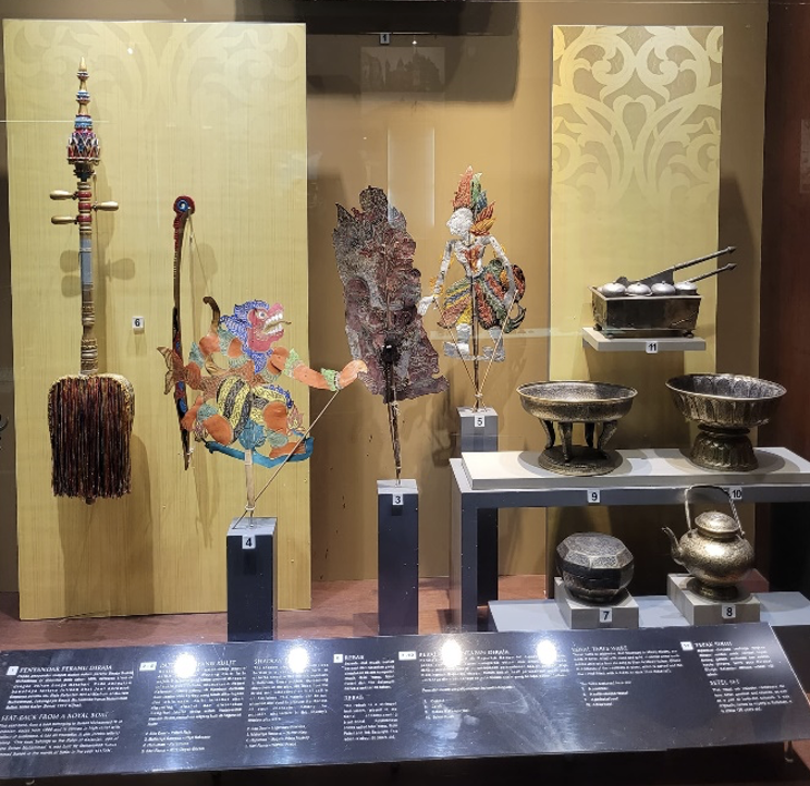
Meanwhile… accompanied by an orchestra of gamelan music, the ‘Tok Dalang’ weaves epic tales in his Shadow Play; as audience cheered, laughed and reflected on the moral and spiritual lessons conveyed.
The enchanting sounds of ancient instruments
The Sounds of Trade
The bustling trade activity in the Straits of Malacca resonated with the voices of Captains as they navigated and competed for harbouring space amongst ships. In this maritime symphony, traders conversed in 84 languages, striking deals and exchanging goods from distant lands.
Spices like pepper, cloves, nutmeg and cinnamon were measured meticulously with conventional weighing instruments for proper governance. These aromatic treasures were sought-after in the markets of Europe, their scents mingling with the salty sea breeze. Silk fabrics and gold brocade, known for their luxurious feel and vibrant colours, were another commodity transported from the Silk route of China. Delicate and beautifully crafted porcelain ceramics exchanged hands, their chime ringing through the marketplace.
Within the hustle and bustle, foreign traders forged connections with the land and its people. They fell in love not only with the promise of prosperity but also with the allure of the local women. While they settled amidst the shifting winds of trade and romance, they blended and became part of this vibrant Malay Archipelago.
Waves of Tales
Seafarers braved and navigated open and treacherous seas. Their courage come alive through the sounds of their flowing sails and crashing waves on uncharted waters. Their heroic journeys were threaded with peril and adventure, heavily relying on monsoon winds as their compass and invisible force.
Stars twinkle overhead in the limitless sky, reflecting their aspirations for trade opportunities in distant lands. Yet, some never reach their destinations, as storms and hidden reefs swallow their voyage quest. Their ships sank together with their precious cargoes.
The marine gateway of South China Sea holds treasures of countless blue cobalt porcelains. Though discoloured, they stood the test of time, telling sunken tales of their journey. Yet many goods were never discovered and remain thrones of the sea. Maybe they needed to be laid to rest, closer to their home…
Arms of Conflict
Iron ore which were smelted under fiery heat, gave birth to the legendary ‘keris’ Local artisans carved each sheath into superior pieces of art. Each blade carried stories of origin and purpose, evoking accounts of power, loyalty and friendship. The clashing of metal on metal, tells of battles fought and victories won or redeemed.
Weapons evolved into modern instruments of war such as guns and large cannons, which ultimately met the same fate of devastation, whether it was the conquest of Melaka or the devastation of Pearl Harbour. These events underscored the transformation of humanity from ‘hunters for survival’ to ‘conquering hunters’, driven by the pursuit of power and wealth. However, history teaches us that every rising power eventually faces its downfall…
Turning Wheels: A Twist of Fate
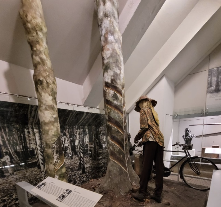
The wheels of the bicycle tirelessly spin in the terrains of rubber estates accompanied by a sonata of insect sounds. Where needed, the bell attached to the bicycle rings out, signalling the arrival of workers to tend to the rubber trees. The latex from the cup is collected and poured into a metal container, flowing like thick milk. Each drop was precious. Amidst the tranquillity of the estates, the occasional rustle of leaves and movements of wild animals, remind visitors of the natural yet tough conditions surrounding them.
The industrious sounds of bicycle and latex
As the nation’s income surged from the export of rubber and tin, Malaya embarked on a transformative journey of infrastructure development, constructing railway tracks and roads to facilitate the transportation of these vital commodities. The rhythmic clatter of steel wheels on tracks and the hum of engines became the soundtrack of progress, echoing the promise of prosperity. This era witnessed an influx of migrant workers, their voices mingled with the sounds of construction, embodying the spirit of resilience and determination.
However, a shadow loomed over Malaya on 8 December 1941. Bicycles – once the symbol of peaceful transportation; were swiftly transformed into instruments of war, as infantry soldiers mounted on them for battle. It forever altered the landscape of Malaya. The terror of war wounded many, a stark reminder of how fragile life can be, when peace is robbed of humanity.
Education – The Song of Catalyst
Schools served as reservoirs of knowledge, sparking enlightenment and offering a future, brighter than that of their ancestors. Within the walls of Malayan classrooms, a symphony of languages reverberated, celebrating diversity.
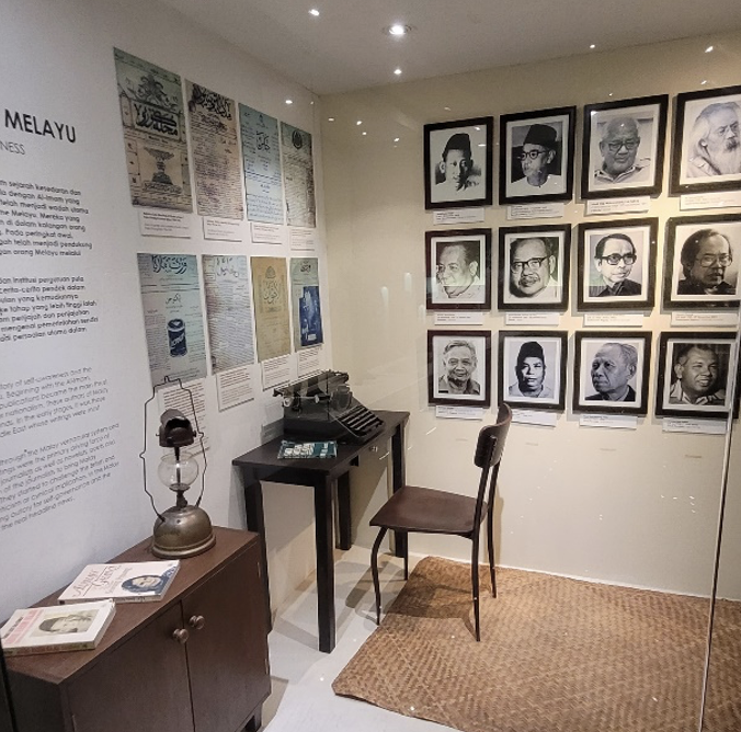
Education served as the catalyst and bridge for expanding minds, fostering awareness and laying the groundwork for Malaya’s independence. From these halls, emerged writers, poets, activists and peacemakers who reshaped societal norms and fuelled the collective dream that – “We too can be the Masters of our Land!”
The liberating sounds of typewriter-keys clacking
Timeless Reminders of Songs
Amidst the echoes of the past, cultural songs and anthems serve as reminders of the more recent history. ’Dondang Sayang pantuns’ and ‘Jingling Nona’ songs represent the rich cultural tapestry of Baba Peranakans and Portuguese Peranakans respectively – the blend of various cultures with the Malay culture.
‘Negaraku’ – our national anthem, symbolised the birth of a nation and became a uniting force among the people. It echoes thru the halls of the museum, for all to hear. And yet it brings goose bumps to older visitors and people of the land, who walked the pre-independence journey with courage and strength.
The sounds of unison of an independent nation
The Sounds of Silence and Rhythm
In the silence of the museum, the sounds of history come alive, inviting us to immerse in the richness and diversity of the human history.
Each sound, each note tells a story. As visitors pause and listen, they become part of that story. Their own experiences merging with those of the past. It is a testament to the power of sound – both the silence and rhythm, to connect with our shared heritage, learnings from the past and into the future. The sounds of museum echoes thru the walls … a moving reminder of the beauty and resilience of the human spirit.
At the MV Focus Talk series, the subject of the day was ‘Lost Diversity of Sundaic Borneo: New Findings from Sarawak.’ Our speaker was Dr. Masatoshi Sone, who shared insightful findings from his recent expedition where he spent a good ten days in the coal fields of Ulu Rajang looking for fossils. The talk began with an exploration of Sundaland, the name of the ancient continent that once included Borneo, Peninsula Malaysia, Sumatra, and Jawa Island. Geologically, Kuala Lumpur is situated in the heart of this vast continent.
Sundaland: A Fragmented Ancient Continent
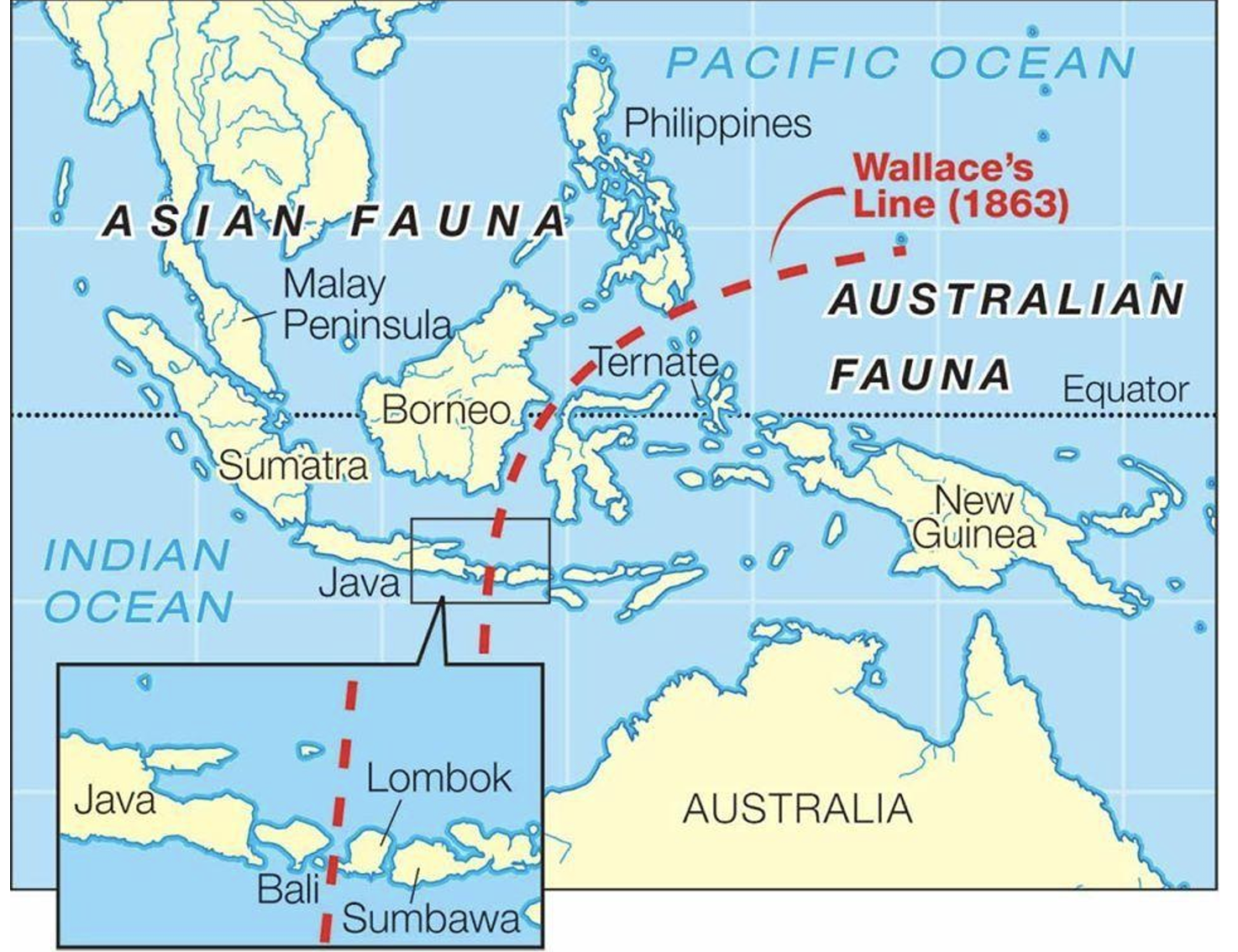
About 11,000 years ago, this was one big piece of land. As sea levels rose, Borneo became separated from mainland Asia and other islands. The Wallace Line, named after Alfred Russell Wallace, a British naturalist who explored the region over a century ago, marks a transition zone between the distinct fauna of Asia and Australasia. This imaginary line runs from the Lombok Strait between Bali and Lombok in the south, all the way up through the Makassar Strait between Kalimantan (Borneo) and Sulawesi in the north. The islands on one side, like Sumatra, are mostly volcanic within a subduction zone with tectonic plates. This goes all the way to the east, including the Komodo islands, Timor Leste, Papua New Guinea, and Australia.
Plate 1: Wallace’s Line
Following Wallace’s Lead: Biogeography and Island Evolution
During his expeditions, Alfred Wallace, a naturalist with a keen eye for geology, noticed a peculiar phenomenon. Many animals, including birds of the same species, were present in Sumatra but seemed to disappear as you moved towards Lombok and the regions west of it. Wallace identified a significant biogeographic boundary between Bali and Lombok. Surprisingly, this invisible line had a profound impact on the distribution of various bird species. Many birds, it appeared, were reluctant to cross even the narrowest stretches of open ocean water. Essentially, Wallace believed that species change over time so they could fit into new environments.
This led Wallace to observe that in Bali, you’d find thrushes, woodpeckers, barbets, trogons, paradise flycatchers, paradise shrikes, minivets, blue drongos, pheasants, and jungle fowl, but colourful exotic birds were a rare sight. In contrast, in Sulawesi, Papua, and Timor, parrots, cockatoos, and lories were abundant.
The Wallace Line extends further between Borneo and Sulawesi, although this boundary is not visible to the human eye. However, animals seem to sense or perceive this invisible division. It’s important to note that Wallace’s discoveries were primarily based on biological observations (where he spent many years obtaining samples of birds, insects and animals) rather than in-depth geological knowledge of the islands. His research led him to a conclusion: animals evolve by adapting to their specific environments rather than by migrating to new ones.
Fueled by a passion to understand how new species arise, Wallace joined an Amazon expedition in 1848 (with Henry Bates). Sadly, a shipwreck in 1852 claimed most of their collected specimens. Undeterred, Wallace embarked on a groundbreaking Southeast Asian voyage (1854) that spanned eight years. His meticulous collection efforts yielded a staggering 125,000 specimens, including the iconic flying frog, and significantly advanced our understanding of the natural world.
A Glimpse into Earth’s Geological Timeline
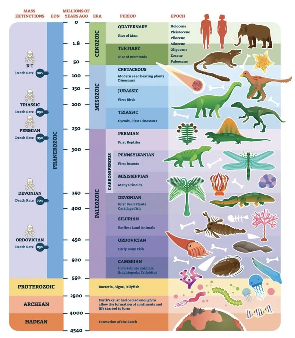
Next ,we looked into the Earth’s geological timeline, which spans an immense 4.6 billion years. A particularly noteworthy period within this timeline is the Cenozoic era, which commenced approximately 66 million years ago. During this era, we witnessed the emergence of mammals and birds, along with the gradual evolution of primates and early hominids.
In the midst of the Cenozoic era (at the boundary between the Cretaceous and Paleogene periods), a large meteorite crashed into our planet, specifically in the area of the Caribbean Sea. This catastrophic impact spelled doom for the dinosaurs and many other species, opening the door for mammals to flourish and diversify.
As we consider Earth’s geological timeline, we find a key division between the Quaternary and Tertiary eras. This shift hinges on the transition from the Tertiary period, encompassing epochs like the Pliocene and earlier, to the Pleistocene and Holocene epochs of the Quaternary. This change mirrors significant shifts in climate, marked by a warming trend and rising sea levels. It’s also notable for the emergence of Homo sapiens, making it a pivotal juncture in our planet’s history.
Furthermore, the shift from the Pleistocene to the Holocene epochs indicates a transition from the last ice age, characterised by glaciers atop Mount Kinabalu. Interestingly, this transition aligns with Earth’s broader climatic cycle, suggesting that we’re gradually heading towards the next ice age in the grand scheme of geological time.
Plate 2: Geological Time Scale
Fossil Fuels: A Legacy of the Cenozoic Era in Malaysia
In the context of Malaysian geology, the Cenozoic period takes on paramount importance. This geological era witnessed the formation of numerous oil and gas (hydrocarbon) resources within the country. Throughout this time, a series of geological processes transpired, which included the accumulation of organic material and the creation of suitable conditions for the development of oil and gas reservoirs.
These developments have solidified Malaysia’s standing as one of the key regions for oil and gas production in Southeast Asia. Notably, substantial reserves can be found both onshore and offshore, underlining the nation’s significance in the oil and gas industry.
Borneo: From Sundaland to Fragmented Islands
Before the end of the ice age, Southeast Asia was part of a landmass known as Sundaland. This area connected many of today’s islands (Peninsula Malaysia, Sumatra and Borneo but also Java, Bali, parts of the Malay Peninsula, and other smaller islands in the region) into a single landmass due to lower sea levels caused by the extensive ice sheets.
As the Ice Age concluded, the rising sea levels, about 110 metres higher, submerged much of Sundaland, including the lowlands between the elevated regions of Peninsula Malaysia, Sumatra, Jawa, and Borneo. This flooding led to the formation of rivers like the Chao Phraya, Pahang, Pekan, Kuching, and Rajang rivers, which were previously part of the terrestrial landscape.
Sarawak’s Caves: A Treasure Trove for Prehistory
Looking at Sarawak, we have some famous caves such as Niah cave, and also Mulu. The caves in this region have been of interest to palaeontologists due to the discovery of prehistoric fossils and archaeological artefacts. These findings have contributed to our understanding of the region’s prehistoric past.
In archaeology, the Niah caves (Sarawak – discovery of skulls in 1958) and Madai caves (eastern Sabah), contain remains of prehistoric human activity, where Niah is famous with coffins together with animal remains, These caves also hold animal remains alongside human artefacts, otherwise for most of Sarawak there is no paleontological record. Evidence suggests human activity in the area began around 30,000 years ago. Fossils, including those of tigers and tapirs, have also been found. Notably, these animals are no longer present in Borneo, having disappeared naturally before human arrival.
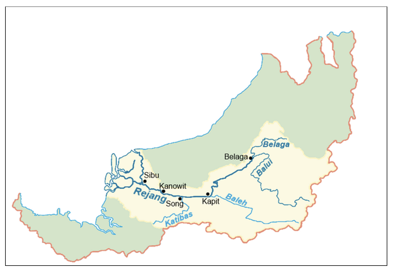
The third largest city in Sarawak is Sibu, where we can journey along the Rajang River (longest river in Malaysia) to Kapit, a town located inland along the river. The Rajang river also flows in the general direction towards the largest dam in Malaysia, the Bakun Dam which is located on the Balui River (a tributary of the Rajang River). Here we now have two smaller rivers or tributaries merging with the Rajang River in Kapit, then continuing downstream towards the river’s estuary, where it meets the South China Sea. This is where the fresh water from the river mixes with the saltwater of the sea.
Plate 3: Rajang river basin
Unearthing Borneo’s Past: The Rajang River and Fossil Discoveries
The Rajang River’s characteristics stand out in contrast to typical slow-flowing and meandering rivers in Malaysia, where it is a straight course and fast flowing. This might be because it originates in or flows through areas with steeper terrain, where the river descends more rapidly. As it approaches Sibu, the river transforms into smaller channels, creating a delta structure. This delta is the product of sediment deposits and the river’s interactions with the sea. It provides a favourable environment for a notable population of large crocodiles, making Sibu their known habitat.
Here at this delta, many fossil remains have been discovered such as spines, fins or ribs of fish. Fossils are often found in black or brown hues, indicating they have undergone the fossilisation process including phosphatisation.
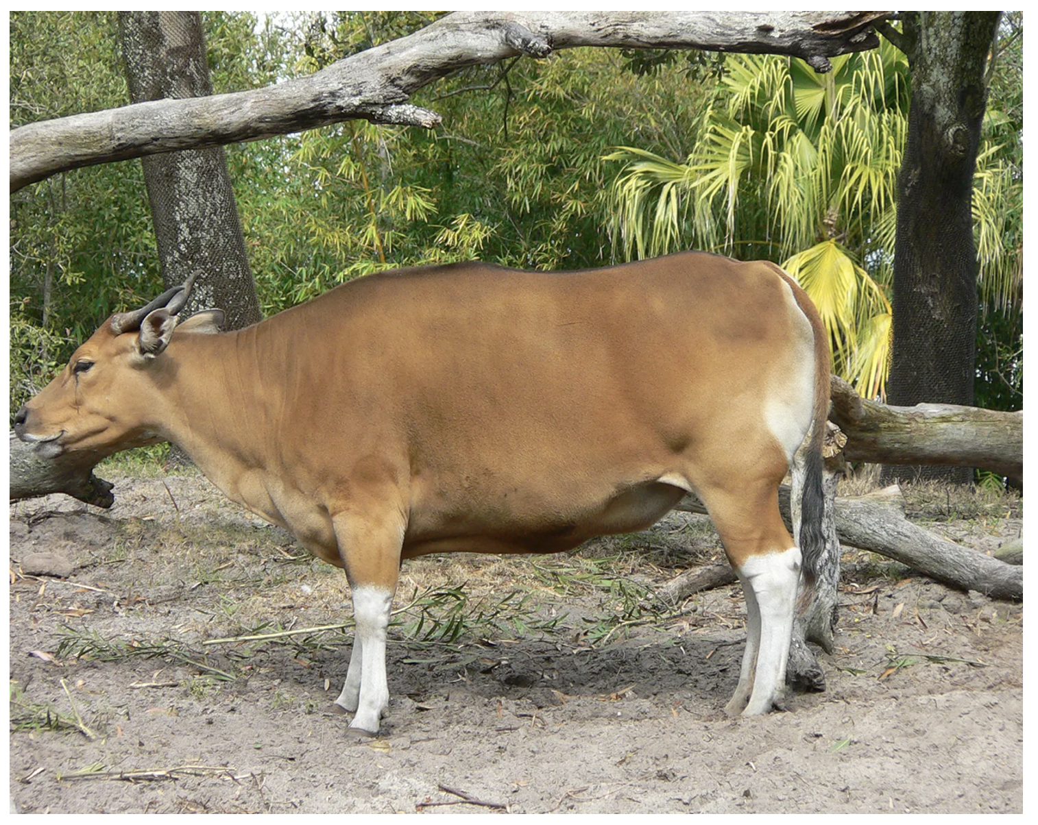
Island Endemism: The Case of the Bornean Banteng
Fascinating fossil discoveries in Sabah include the premolars of the Banteng or Tembadau in Malay (species: bos javanicus), a wild cow species, which we understand has been here before humans and during Sundaic time as well. Bornean bantengs are smaller due to a phenomenon called “insular dwarfism” or “miniaturisation.”, where island-dwelling mammals tend to evolve smaller body sizes over time (same applies for African elephants and Asian elephants). This phenomenon is a remarkable example of how isolated island environments can influence the evolution of species, leading to unique adaptations and characteristics. The Banteng is facing a gradual decline in Sarawak and is on the brink of extinction in Malaysia. Currently, Cambodia hosts the largest population, followed by Australia. It’s important to note that these populations in Cambodia and Australia are not native but were introduced by humans.
Plate 4: Banteng (wild cow)
Echoes of the Past: Fossil Tapirs and Their Relatives
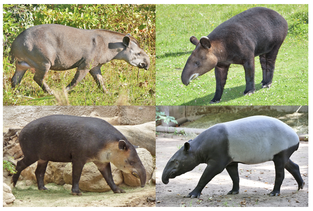
Fossils of tapirs, identified as a type of metatarsal belonging to the extinct Tapirus sp., have been found in the Niah and Madai Caves. However, these tapirs are not directly ancestral to the present-day Malayan tapir. While they may have shared similar black and white stripes, these extinct tapirs inspired legends of a mythical creature that came through China and could eat our trees.
There are four species (four genus) of Tapirs in the world:
Lowland Tapir (Tapirus terrestris)
Baird’s Tapir (Tapirus bairdii)
Mountain Tapir (Tapirus pinchaque)
Malayan Tapir (Tapirus indicus)
Plate 5: Tapir
Today’s DNA studies confirm the Malayan tapir as the sole surviving Asian tapir species, with its closest relative being the American tapir. Evidence suggests tapirs originated in Eurasia, where they are now extinct. The split between Malayan and American tapirs likely occurred around 25 million years ago, predating the most recent ice age. This time frame coincides with periods of lower sea levels that exposed land bridges, allowing many mammal migrations like horses, sheep, and even some Asian monkeys to move from Eurasia to North America and eventually South America. While the tapir story might not directly involve the most recent ice bridge, it highlights how continental movements and changing sea levels have shaped the distribution of animals throughout history.
Extinct Tapir Diversity and Zooarchaeology
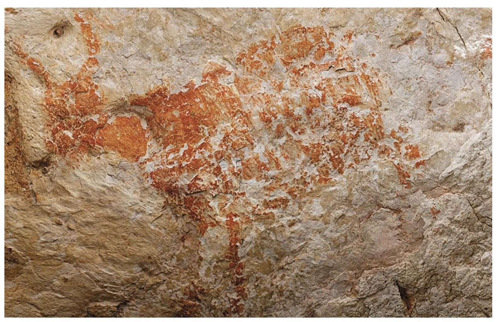
While the Malayan tapir is the only survivor in Asia, evidence suggests a greater diversity of tapirs once existed. A striking example comes from the Lubang Jeriji Saléh cave in East Kalimantan, Borneo. This prehistoric limestone cave, dating back to the Pleistocene epoch, features a large reddish-orange figurative cave drawing of animals. These depictions, alongside fossil remains like those of tigers now absent from Borneo, highlight the valuable role of zooarchaeology in reconstructing past ecosystems. By studying animal remains and artistic representations, we can gain insights into species that no longer roam these regions.
Plate 6: Cave drawing at Lubang Jeriji Saléh, East Kalimantan, Indonesian Borneo
Uncertain Fossil Identity and Regional Rhino Extinction
Some fossils unearthed in East Malaysia reveal animal hooves that could belong to either tapirs or rhinoceroses. Unfortunately, differentiating between them solely based on hoof characteristics is challenging. Sadly, rhinoceroses are already regionally extinct in East Malaysia. The last recorded Sumatran rhinoceros in Sabah died in 2015, prompting the government to declare its local extinction. However, there’s a glimmer of hope. A small population of 10 to 20 individuals was discovered in East Kalimantan in 2016, highlighting the importance of conservation efforts for this critically endangered species.
Fossil Evidence of Sea Cows (Sirenia) in Sarawak
Aquatic mammal fossils, identified as sea cows (Sirenia) or dugongs, have also been unearthed in Sarawak. These gentle giants, related to manatees found in Central America and the Caribbean, once thrived in the coastal regions. They fed primarily on seaweeds. Sadly, sea cows are now locally extinct in Sarawak.
One key characteristic that aids in identifying Sirenia fossils is their density. Due to their composition of calcium carbonate, these bones are significantly heavier than most other animal remains. This weight factor alerted Dr. Sone’s team to the possibility of a Sirenia fossil upon discovery.
The Enigma of the Tambun Cave Dugong
The Tambun limestone cave in Ipoh boasts archaeological paintings, estimated to be around 5,000 years old, featuring an image resembling a dugong. This poses a fascinating puzzle considering the significant distance between the current coastline and the cave’s inland location. Further research, potentially involving geological studies and a deeper analysis of the cave paintings, might shed light on this intriguing mystery.
Plate 7: Tambun (Ipoh) cave painting: dugong
The Story of the Suidae Family and the Bearded Pig
The Suidae family, encompassing wild pigs and boars, boasts a global distribution across Eurasia, North Africa, and the Greater Sunda Islands. Evidence suggests their origin lies in Southeast Asia during the Pleistocene epoch (1.4 million to 11,000 years ago). From this ancestral homeland, they likely migrated outwards into other parts of Eurasia.
Wild Pigs of Borneo: Bearded Natives and Introduced Relatives
Borneo boasts two distinct wild pig species, both belonging to the genus Sus. The first, and likely more familiar, is the wild boar (Sus scrofa). While not native to Borneo, this species can interbreed with domestic pigs. The second, and truly indigenous pig, is the bearded pig (Sus barbatus). Fossil evidence, particularly differences in molar morphology, helps differentiate these two species.
Distribution patterns paint a clear picture. The common wild boar, also known as the Eurasian wild boar, dominates across Eurasia, with introduced populations in Australia and northern South America. In contrast, the bearded pig reigns supreme in Borneo, with a smaller presence in Peninsular Malaysia. Interestingly, fossils from the Niah Caves reveal no evidence of the common wild boar, only the bearded pig. This suggests that the wild boars currently found in Borneo were likely introduced by humans.
However, there’s a twist! Fossil discoveries in central Sarawak showcase the presence of both pig species even before human arrival. This intriguing find remains an active area of research.
Summary
Understanding Borneo’s rich biodiversity, both past and present, is crucial for informing conservation efforts and protecting this irreplaceable natural heritage. Dr. Masatoshi’s team is currently exploring fossils of a fly and plant fossils in a coal mine in Sarawak.
Reading material from MV Library
Here are some books that would likely be excellent reading material for further exploration:
1. Borneo Biodiversity: Tropical Rainforests from the Heart of Southeast Asia (ISBN 9789811073447) by Eric D. Wikramanayake, Michael D. Sorenson, and Thomas J. Conway
2. Island Biogeography: Theory and Conservation Practice (ISBN 9780691166488) by David Wright
3. A Field Guide to the Mammals of Borneo (ISBN 9789834280635) by J. Payne, C. Francis, and K. Phillipps
4. The Quaternary Period (ISBN 9780131174749) by John A. Quaternary
5. Encyclopaedia of Malaysia: Volume 4. Early History by Dato’ Nik Hassan Shuhaimi Nik Abdul Rahman
6. The Malay Archipelago by Alfred Russell Wallace
As we all know, Federal Territory Day has been celebrated on 1 February every year since its inception in 1974 when Kuala Lumpur was transferred to the Federal Government. Of late, areas around Kuala Lumpur Chinatown have come under close scrutiny. Authorities have launched a security operation to curb the influx of foreigners to the area. The area is also affected by the increasing presence of homeless individuals and the worsening rubbish problem.
The relocation of the popular Pasar Karat / flea market to a new location which was supposed to have been carried out at the start of the new year has met with objections from traders of both locations.
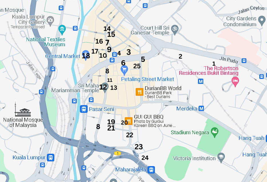
I had the opportunity to participate in an early morning walking tour covering the heritage sites in and around Chinatown, and probably get a first hand impression of the issues as mentioned above.
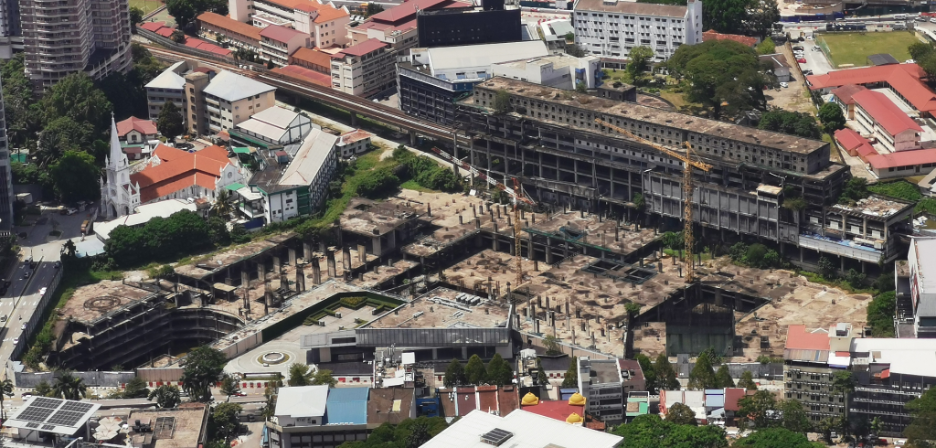
Construction site of Plaza Rakyat, photo taken on 17/3/2023 – Photo source : Wikimedia Commons
The first site was (1)Plaza Rakyat which is located on Jalan Pudu. When the project was first announced in 1993, it was to be a large-scale mixed use development in prime CBD location. Following the 1997 Asian financial crisis, the developer faced financial difficulties and the project was halted. In 2014, DBKL took over possession of Plaza Rakyat and in the following year, it was sold to a new developer. However, there has been little progress in the project until today. With the completion of commercial developments within the city like Tun Razak Exchange (TRX) and Menara Merdeka 118, Plaza Rakyat will have a huge task to market its office and commercial space, and that again, if the project ever sees the light of day.
Prior, the site was a football ground for the Selangor Chinese Recreation Club (SCRC). The club had produced many Chinese footballers who went on to don state and the black and yellow national jerseys. The most illustrious player was the late Wong Choon Wah. He was the first Malaysian player to play professional football in Hong Kong, from 1972 to 1974 and was a member of the national team that played in the 1972 Munich Olympic (the only time that we played in the Olympic). In all, he won 88 caps and scored 20 goals for the country.
UTC KL (Pudu Sentral / Puduraya Terminal) / Photo source : Eric Lim
Sitting next to Plaza Rakyat is what is known today as the (2)Urban Transformation Centre KL (UTC KL). It is one of the initiatives undertaken by the government in providing the urban community with key government and private sector services under one roof. The building was originally built to be a bus terminal / interchange and was known at that time as Puduraya Terminal (Hentian Puduraya in Malay). It was officially opened in 1976 by the late Prime Minister Tun Hussein Onn, the third Prime Minister of Malaysia. It soon became the major transportation hub in the city and as a result, it created massive congestion in the area. Bus operators were then gradually moved to inter-regional hubs in other parts of the city, namely Jalan Duta bus terminal (or Hentian Duta) and Bandar Tasik Selatan Integrated Transport Terminal (BTS ITT) which started operation on 1 January 2011. In 2011, Puduraya was renamed as Pudu Sentral after it had undergone major renovations and upgrading works. The following year, it became the Urban Transformation Centre for Kuala Lumpur.
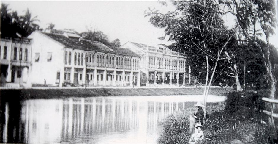
According to Teo Chee Keong, a researcher, architect and co-author of the book “The Disappearing Kuala Lumpur”,the site of the current UTC KL was once a dam. He backed this up with a photo of the dam which he believes to be taken in the 1910’s and an old map showing a stream that flowed from Bukit Bintang (near Jalan Alor) to the dam, and continued westward towards the Central Market area and finally merged into the Klang River. Later, the British built a railway track and a road next to the dam (right and left respectively). The road eventually turned into an arterial thoroughfare connecting Jalan Pudu to Cheras. Further checking on the progress of the dam over the years, there are two historical records from Malaysia National Archives (see link below). The first document is a Minutes of Meeting dated 9/4/1903 which recorded the call for tenders for the Pudoh (the initial name) Dam Fish Farm. This confirmed the fishing activity that can be seen in the photograph taken from the book. And the second record is a document dated 17/7/1914 on the reclamation of Pudoh Dam which by this time, was downsized to a pond and accordingly called Pudoh Pond.
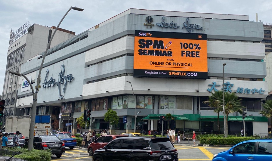
Kota Raya and Wisma Fui Chiu (building on the far left) / Photo source : Eric Lim
We walked across the busy Jalan Pudu intersection towards Jalan Tun Tan Cheng Lock and stopped in front of (3)Kota Raya. Tun Tan Cheng Lock was the first President of Malayan Chinese Association (MCA). It was said that the building was built in the 1960’s but this information could not be true as the first shopping complex built in the country was Ampang Park Shopping Complex which was built in 1973 (sadly, Ampang Park ceased operations on 31 December 2017). Boosted by its high street location, Kota Raya soon became a popular shopping complex when it was opened. Overtime and with the emergence of newer and bigger shopping malls particularly around neighboring Bukit Bintang, it saw a major shift in clientele and it faded into oblivion. Today, the retail podium and kiosks in Kota Raya are mainly operated by foreigners and the fifth floor has been repurposed and converted into a budget hotel. Kota Raya has acquired a reputation as the hub for workers and tourists from the Philippines and is tagged as “Little Manila’.
Jalan Tun Tan Cheng Lock was previously known as Foch Avenue. There were two landmarks along this road, and the first was the (4) Fui Chiu Association Building. The original building was four-storey high and was built in the 1930’s. One of the tenants during its early days was the Communist Party of Malaya (or Malayan Communist Party / MCP). The party stayed on until it was declared illegal in 1948. It also houses the Tsun Jin High School when its campus was destroyed by the Japanese during the war. In November 1985, the building was torn down for the construction of a new (4)Wisma Fui Chiu. The project was delayed and only received the Certificate of Fitness in 1992. The top two floors are being used by the clan association until today.
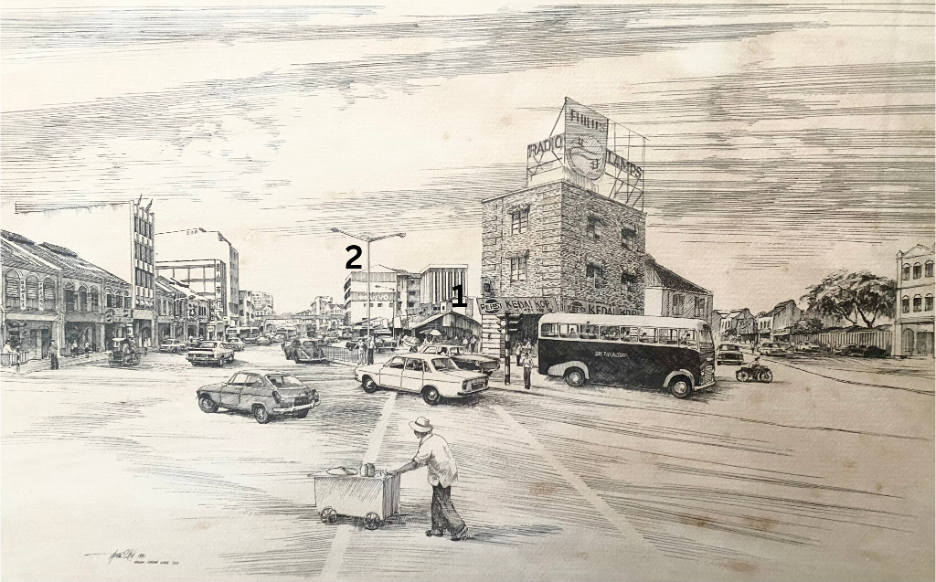
Drawing of Foch Avenue in the 1970’s, showing the exact location of Kota Raya before it was built (1) which was then a bazaar with a row of stalls and next to it on the background was Fui Chiu Association Building (2) / Photo source : Eric Lim
The second landmark was the (5) Sultan Street Railway Station. It was the second station built in Kuala Lumpur, after the first Kuala Lumpur station which was nicknamed Resident Station. The line connecting the first KL Main Station to Pudu through Sultan Street Railway Station was opened on 1 June 1893, and was followed by the extension to Sungai Besi in 1895 and Kajang in 1897. The beginning track between the first KL Main Station and Sultan Street Railway Station ran across the Klang River and between two busy carriageways located at Foch Avenue. This railway track was dismantled in the 1910’s and Sultan Street Railway Station became a terminus station. It remained until 1972 when it was closed for the construction of Puduraya Terminal. Some part of the old route is still being used by LRT Ampang Line
Sultan Street Railway Station in the 1950’s. Photo source : Asian Railways
1908 KL Map showing the railway track from the first KL Main Station to Sultan Street Railway Station (1) and location of the Pudoh Dam / Pond (2) / Photo source : Asian Railways
We have reached the intersection between Jalan Tun Tan Cheng Lock and Jalan Petaling, standing directly opposite the (6) arch / gate entrance to Petaling Street. This bustling section of Petaling Street has recently been given another boost when it was voted as one of the coolest streets in the world’s best cities by global magazine, Time Out. The last few years have seen a renaissance rollicking through this part of old Kuala Lumpur with the emergence of trendy, bold and creative food, drink, and nightlife scenes. We continued our walk on the other section of Petaling Street to its end point and at the junction, it connects to High Street that runs across and a bit further down the road, Pudu Street intersects and joins Jalan Petaling, forming a triangle of sorts. And rightfully, this area was known in the early days as (7) The Triangle. However, for the Chinese, they called it ‘Ng Jee Dang’ (five lamps). This area encompasses mostly goldsmiths and pawn shops and the set up of these lamps had helped to improve visibility and security for the area. At that time, it was believed that it was the most brightly lit area in town.
(8)High Street was so named because of its elevated position above the average flood water level of the nearby Klang River and it stretches across old Kuala Lumpur.
Today, there are many changes to the name of the areas and the streets in Kuala Lumpur. Pudu Street at The Triangle is now changed to (9) Lebuh Pudu. Still, there are a rare few that still maintain its original names and a good example is Petaling Street. Of course, today it is Jalan Petaling. But still, the Chinese, until today, prefer to call it Chee Cheong Kai / Tapioca Factory Street (茨厂街) in reference to the tapioca factory that was owned by Kapitan Yap Ah Loy and was located along the street. The Triangle / Ng Jee Dang is today known as the (7)Historic Triangle. Most of the goldsmiths and pawn shops have moved out or ceased operations, and the area is strewn with rubbish. Many homeless folks are seen in the area too. Save for some newly planted trees and shrubs that add some greenery, the Historic Triangle will never catch up to the other triangle i.e KL Golden Triangle. High Street was later changed to Jalan Bandar, and followed by another change in 1988, to be known until today as (8)Jalan Tun HS Lee. It is in honour of Colonel Tun Sir Henry Lee Hau Shik who passed away in 1988 and he was our country’s first finance minister (1957 – 1959). He was one of the representatives of the Independence Group to London which met officials from the British Colonial Office to demand independence for the Federation of Malaya.
There are several historical landmarks particularly places of worship that are more than 100 years old, located along Jalan Tun HS Lee –
(10) Sin Sze Si Ya Temple(仙四师爷庙)
The temple that Kapitan Yap Ah Loy built in 1864 is believed to be the oldest Chinese temple in Kuala Lumpur. Last year, they started a museum on the top floor of the shophouses in front of the temple, that showcases the history of Kuala Lumpur and Sin Sze Si Ya Temple. The museum is open daily, from 10.00 am to 5.00 pm (effective 1 April 2024).
(11) Guan Di Temple (关帝庙)
In 1886, Chinese immigrants from two prefectures namely Guangzhou and Zhaoqing, both in Southern China, got together and formed the Kwong Siew Association. The following year, Guan Di Temple was built and is dedicated to the God of War / God of Righteousness. Besides the temple, the association also runs a Library (now called Zhou Yu Library and Information Centre after one of its founding members) which started in 1924 and a free school that provides tuition classes in Mandarin since 1927. One of the main attractions is the Guan Dao (Long Knife) which was brought in from China and is more than 100 years old. It will be on display at the centre court on certain festivals.
(12) Sri Maha Mariamman Temple
Initially used by Thamboosamy Pillai (prominent leader of the Tamil community during the pre-Independence years) and his family as a private shrine before it was moved to the current site in 1885. It transformed from attap structure to brick building in 1887 and to the current temple building in 1968. Visitors to the temple will be greeted by an impressive 5 tiered gopuram (temple gateway) which is 22.9m / 75 feet high, decorated with depictions of Hindu gods sculpted by artisans from southern India. During the annual Thaipusam festival, the silver chariot which is kept in the temple will be used to transport the statue of Lord Muruga and his consorts through the streets of KL to Batu Caves. The temple is open daily from 6.00 am to 9.00 pm.
(13) Madras Theater
Opposite Sri Maha Mariamman Temple is a small alley which used to be called by the name of Madras Lane. It was called in conjunction with the Madras Theater which was sited inside. The theater shows only Chinese movies despite its name and was run by Shaw Brothers. It was burned down in a fire in 1978 but was never rebuilt and has since turned into an open air car park. And this is the new site for the relocation of the Pasar Karat / flea market which was to be carried out at the start of the year but it did not happen.
Moving ahead, we have arrived at another intersection where Jalan Yap Ah Loy is directly opposite where we stood. It is a short street and probably the most distinct structure located here is the (14) Maybank Tun HS Lee Branch. This corner lot, seven storey building is where Maybank first started its operations on 12 September 1960, becoming the first homegrown bank to serve Malaysian society. In its early years, Maybank was nicknamed ‘coffee shop bank’ because their branches mostly occupied shop lots that were formerly coffee shops or were situated next to one! Maybank Tun HS Lee Branch continues to operate, thus making it the oldest Maybank branch in the country. Opposite the bank and next to a red building is an alleyway called (15) Lorong Yap Ah Loy, and this is where a colourful information board depicting the life of Kapitan Yap Ah Loy is located. Lorong Yap Ah Loy was one of the laneways around the vicinity that was upgraded in a project in 2018 by DBKL and Think City (a community based organization) that aimed at creating clean, safe and vibrant spots for pedestrians and tourists. Also sited here is a pushcart lady offering cake, swiss roll and kaya puff; and farther down, a popular Chinese noodle eatery which was established before Independence.
Maybank Tun HS Lee Branch (left) and the red building (right) / Photo source : Eric Lim
We stopped for a breather on Leboh Pasar Besar, before we continued on until we reached the front of Pacific Express Hotel. Looking across the street, we have a clear view of the (16) Medan Pasar Clock Tower. And it was here at Medan Pasar that the first few wooden huts, stalls and a market were set up and it soon developed to become the commercial hub of the town. During the late 1800’s, most of the businesses were controlled by Kapitan Yap Ah Loy and the street was then known as Hokkien Street or Macao Street by the Chinese community. In 1884, Kapitan Yap Ah Loy built the first two storey brick shophouses here and some of these buildings are still standing until today. Later, under the British administration, the street name was changed to Old Market Square. The clock tower at the centre of the public square was erected in 1937 in commemoration of the coronation of King George VI but the original plaques have been removed sometime after Independence. The structure was designed by Arthur Oakley Coleman who also designed a number of buildings in Kuala Lumpur including the Odeon Cinema which was designed in 1936. Returning to the (17) Pacific Express Hotel, it was believed that it was once the location of Kapitan Yap Ah Loy’s house and Leboh Pasar Besar was then called Market Street. Leboh Pasar Besar continues past the Klang River Bridge, to the west bank of the river until it meets Jalan Raja. At the right side of the Klang River Bridge, there is a platform that offers a wonderful view of the confluence of Gombak River and Klang River (left and right respectively) with Masjid Jamek Sultan Abdul Samad (renamed in 2017) nestled in-between. In 2011, both rivers were roped in to the River of Life project which aimed at transforming its river basin areas from a previously uncompetitive and dirty river to a dynamic and habitable waterfront icon with high economic value. In the evening, the fog and lighting effects will further enhance the vicinity by transforming it into a Blue Pool. This lookout point is fast becoming a popular area for locals and tourists to gather.
2 storey brick shophouses built by Kapitan Yap Ah Loy / Photo source : KL City Gallery
Confluence of Gombak and Klang river and Masjid Jamek Sultan Abdul Samad lookout point / Photo source : Eric Lim
We then returned to the other side of the road to Jalan Benteng that runs along the embankment of Klang River, to our next destination, (18) Central Market or now known as Pasar Seni. The Central Market was to replace the earlier wet market that was built by Kapitan Yap Ah Loy at Medan Pasar. It was built at the same location and still functions as a wet market. It opened in 1888. Since then, it had undergone many expansions and upgrades until it was declared obsolete in 1930. The new Central Market was moved to the current site and a new building was constructed and was ready in 1937. It is built in the Art Deco architecture which was trendy during that era. The two structures mentioned earlier i.e Medan Pasar Clock Tower and Odeon Cinema are also of the Art Deco style. Art Deco comes from the French word ‘Arts decoratifs’ which literally means Decorative Arts. It was used until the 1970’s, and due to the rapid development and the massive traffic congestion in the city centre, of which the neighbouring Puduraya bus terminal which was opened in 1976 contributed much to the traffic woes, a new market was deemed necessary, thus Pasar Borong Selayang (Selayang Wholesale Market) came into being. Plan was afoot to re-develop Central Market and the surrounding area by the new owner but it was saved by concerned citizen groups including the Heritage of Malaysia Trust (Badan Warisan Malaysia), and the building was saved and declared a heritage site. In 1985, it underwent renovations and transformed to a centre for Malaysian cultures, arts and handicraft. It was officially opened by Dato Seri Rafidah Aziz who was then the Minister of Public Enterprises in 1986, in conjunction with the PATA Conference. There are new additions made to this popular tourist attraction, which include added mezzanine floors in the main building, Central Market Annexe which is located at the back of the building and Kasturi Walk; a covered pedestrian sidewalk market which took part of Jalan Kasturi (thus the name) which was formerly known as Rodger Street (named after the first British Resident of Pahang 1888-1896, Sir John Pickersgill Rodger). The Central Market / Pasar Seni is a successful example of the adaptive reuse of a historical building.
Postcard showing the first Central Market that was built in 1888 at Medan Pasar. The description from this photo source also went on to inform that the rotunda (round building with a dome on top) in the foreground is the approximate location of the Medan Pasar clock tower.
Photo source : Wikimedia Commons
Interestingly, there is an old British Colonial Post Box erected on the left side of the main entrance. According to the information available, it was placed there in 1989 and it is one of 27 such post boxes that still remain in our country. The cast iron pillar post box was made / crafted by McDowell, Steven And Company Limited, an iron foundry which was established in Glasgow, Scotland. It went on to say that the markings on the post box indicates that it was made during the reign of King George V i.e from 1910 to 1936. However the ‘GR’ insignia indicating the reign is missing. Pillar boxes were first installed on the island of Jersey, Channel Island on 23 November 1852 before it moved to the British mainland the following year. They were painted green and only changed to red in 1874 when people complained that they were difficult to find the green post boxes! By the end of the 19th century, red pillar post boxes were distributed to other Commonwealth nations.
The red pillar post box at Central Market / Photo source : Eric Lim
We are now coming to the last leg of the tour as we made our way through Jalan Tun HS Lee, passing by Guan Di Temple, Sri Maha Mariamman Temple and turning left at the MRT Pasar Seni Entrance A gate to Jalan Panggong, then to Kafei Dian for our lunch. This cafeteria is housed in an (19) old Post Office that was established in 1911. The cafeteria is conveniently located next to (20) Kwai Chai Hong which is just across the road and (21) Gurdwara Sahib Polis, located in front, on the connecting Jalan Balai Polis. And located just next to the Sikh temple is the Four Points by Sheraton Kuala Lumpur, Chinatown hotel.
Kwai Chai Hong is in the Cantonese dialect which translates to mean ‘Ghost Lane’ or ‘Little Demon Alley’, was launched in 2019 and has since been attracting visitors with its insta-worthy interactive murals,many instagrammable spots and interesting seasonal art installations. Incidentally, one can see a century old lamp post here, and it may probably be the same type as the ones installed at Ng Jee Dang!
Gurdwara Sahib Polis was originally known as Gurdwara Sahib Police High Street and it was built in 1898 by the Federated Malay States Police. At that time, more than half of the FMS Police were Sikhs. It is the second Police Gurdwara to be built in KL, the first being Gurdwara Sahib Police Jalan Parliament (previously Club Road). It was reported that there have been no major changes to the original structure of Gurdwara Sahib Polis.
Old Post Office @ Jalan Panggong / Photo source : Eric Lim
Gurdwara Sahib Polis / Photo source : Eric Lim
Now turning to the (22) southern end of Jalan Petaling which the Chinese community once referred to as Coffin Street due to the appearance of numerous funeral coffin shops along this section of the street. One of the participants remembered seeing one such shop in the 1980’s. It is the beginning point of Jalan Petaling for motorists coming in from Bulatan Merdeka. And situated at the corner, next to Lorong Petaling, is (23) Chan She Shu Yuen Clan Ancestral Hall. Looking at the facade, many would have guessed it is a Chinese temple but it is actually a clan association building. It is an association for Chinese people with the surname ‘Chan’, ‘Tan’ and ‘Chin’, all of which are written in the same Chinese characters. The association was founded in 1896 and in the following year, one of the founding members, Chan Sow Lin won a bid for seven adjoining shoplots (current location) from the Selangor Government. Construction of the building which follows the original association hall in Guangzhou, was delayed several times and was finally completed in 1906. In a recent restoration work, grey roof tiles were used in deference to the original model in Guangzhou.
Just a short distance away and situated on a hill to the right of Chan She Shu Yuen Clan Ancestral Hall is (24) Kuan Yin Temple. This temple was originally built by the Hokkien Chinese in the 1890’s and it served as a place to offer prayers for those buried in the graveyard that was once located on the hill. And right behind Kuan Yin Temple, is Menara Merdeka 118 which is currently the second tallest building and structure in the world, standing at a height of 678.9 m.
We made the last stop in front of the former (25) Rex Theater. It opened on 28 July 1947 and was operated by Shaw Brothers. It caught fire in 1972 and Golden Screen Cinemas (GSC) took over from 1976. Another fire destroyed the building in 2002 and it ended its glory days as a cinema. It came back to life in 2007 as a hostel but in the same year, fire again brought it down on its knees. In 2018, the building was repurposed into a cultural and creative hub known as REXKL. It also featuresF&B outlets, a bookstore and the newest addition of a digital art gallery on the first floor.
Rex Theater in its early days / Photo source : RXPKL
By Julian Candiah – MV Focus Talk of 24th February 2024
Written By Hani Kamal
Julian Candiah is a collector of antique maps and sea charts from Malaysia and Singapore. He read Engineering at Magdalene College, Cambridge University, and graduated with a First-Class Honours in 1991. He started off as an international banker at Credit Suisse Financial Products, Bear Stearns, JP Morgan, and BNP Paribas in London, Hong Kong and Singapore (1994 to 2007) before joining Merrill Lynch in 2006. In 2007, he was into private equity and investments. In April 2009, he worked pro bono for the state of Penang, acting as the Special Advisor to the Chief Minister. He is currently working on short articles on the history of Johor from the early 19th Century. He has a collection of over 20 sea from the English, Dutch, French and Italian cartographers in his 40 years of collecting. For him collection is genre. A specialised pursuit to acquire old maps involving very distinct set of skills related to acquiring, preserving, and sharing his knowledge about these maps.
The first half of the talk centred around maps about the Straits of Malacca drafted by connoisseurs of sea charts, Sebastian Munster (1530s), Ortelius, Antwerp (1570), Jan Huygen Van Linchoten (1595), De Bry Frankfurt (1598), John Thornton (1701) and Johannes van Kullen (1753). He ended with sharing maps from the English, like Robert Dudley, Florence: Straits of Malacca (1646); Jacques Nicholas Bellin, Paris: Straits of Malacca (1755); Jean Baptiste de Mannevillette, France: Straits of Malacca (1775), and William Heather, London: Straits of Malacca (1803).
Map 1 First SEA Standardised Atlas
Map 1 This the first South East Asia standardised atlas from 1570 created by Abraham Ortelius. Ortelius collaborated with geographers worldwide to standardise the map, which was then compiled into a book that became one of the most expensive works of its time. It is obviously evident that the sizes of Malaysia, Java, Borneo, Philippines, Japan, Australia, and Papua New Guinea are significantly distorted on the map. The map of Japan has no Hokkaido and Luzon is missing from the Philippines. Interestingly, the map accurately depicts the smaller islands known for clove or spice production.Historically, the strategic port of Malacca was captured by the Portuguese and Dutch due to its essential services such as loading/repair facilities and a readily available food and water supply. These colonial powers then swiftly moved on to the spice islands in search of valuable spices, often referred to us “gold” due to their immense value. Remarkably, current assessments indicate that this historic map holds a significant value of USD4000 or more on eBay.
Map 2 Linchoten Colored Map
Map 2 A full coloured map in 1595, but originally in black and white by Jan Huygen Van Linchoten (1563-1610). He was a Dutch and he spent five years working for the Portuguese as secretary to the Archbishop of Goa. His materials and information were gathered from sailors and he made multiple copies of it. Linchoten is noted to have contributed to the maps of South East Asia in his book “Itenerario”. This map is one of the earliest to depict Singapore as “Sincapura”. Linchoten’s map,obtained secretly through Portuguese sailors, shows seafaring and trading routes; subsequently allowing other European powers to sail safely into the spice islands and breaking the Portuguese monopoly in the spice trade.
Map 3 Inverted Map in B&W
Map 4 Inverted Map in Color
Map 3 & 4 This map is inverted as the direction is coming in from India. As it was from the Portuguese nothing much was described on Java or Borneo, nor Korea, and Japan is out of perspective. However, mappings of Peninsula Malaysia was very much established. As the map was compiled from sailors, sailing lines were notable. Current value of the Linchoten map is worth USD19,000.
Map 5 First Printed Map of SEA in B&W
Map 5 The first printed map of South East Asia in black and white, and later added with colours.Theodore de Bry was born in 1528 in the Prince-Bishopric of Liège, in the southern Netherlands (today Belgium). He was trained as a goldsmith in his father’s workshop and later as a copper engraver in Antwerp. He moved to London and lived near a printing house, and it was here that he was inspired to produce maps that made his name known. This particular map is decorated with beautiful ornate cartouches on map title and filled with rhumb lines showing bustling crossings. A lot of details were found along the Straits of Malacca indicating robust activities and frequent stops by trading ships. Copy of the de Bry map was auctioned and acquired by the The National Museum of Singapore.
Map 6 English Map
Map 6 Map of Malacca and Singapore by John Thornton, Hydrographer of East India Company, London, 1701. This map is a 100% copy of a Dutch map of Malacca and Singapore. At this time there were free flowing sharing of information and usage of English was beginning to appear in maps. By 1753 maps were printed commercially. The map above has detailed travel routes of the islands, but the island of Singapore was still hardly visible. This map is worth USD12,000-15,000.
Map 7 Series of Maps 1803-1855
Map 7 The series of four maps between 1803 till 1855 illustrate the transformation of Singapore from a relatively obscure island to a thriving trading centre frequent by ships. In earlier maps, Singapore was often spelt as Sincapore and was barely discernible on English maps. Its significance as a trade centre for the British only grew after the British withdrawal from the settlement in Java. By 1855, one can see through the sea charts incorporated with land details such as street names, rivers, etc in detail.
Map 8 Map Made with Vellum
Map 8 Vellum vs paper: These are maps printed on vellum, sheep skin. Vellum was used since early 14th century by Italian navigators, one Bartolomeo Crescenzio (1587-1602) in his Mediterranean quest described vellum and maps, “Bartolomeo Crescenzio: “Nautica Mediterranea”, published in Rome, 1602 and 1607 by Bartolomeo Bonfadino. He was employed in the Naval Ships of Pope Sixtus V and Pope Clement VIII. Professor Ferro wrote as follows;
“There is little uncertainty, for instance, about the materials used and the techniques of execution. Nautical charts were hand-drawn on sheep vellum. The larger ones took up an entire pelt, preserving all of its characteristics and dimensions, i.e., a rectangular shape longer on one end (corresponding to the animal’s neck), where it forms the so-called linguetta [small tongue] or umbilicus; the opposite end was generally attached to a stick around which it was rolled (this explains the tears now visible, caused by forcible attempts to detach it). Of course smaller charts, depicting less extensive areas of sea and land, have other shapes (though still generally rectangular). These were mounted on wooden tablets or cardboard and met a different fate as far as preservation is concerned.
Following the tanning process, the parchment was treated and prepared in a timely manner, according to a procedure that was fully illustrated around the year 1600 by Crescenzio. To bleach its inner side (the side on which the design was to be traced) and to make it smooth, the vellum was rubbed with white lead and dried with a white cloth. Then the leftover skin bits were boiled in water until the mixture became thick and viscous. Another cloth (or a sponge) soaked in this fluid was then passed all over the well-stretched parchment. Once dry, this was rubbed with white lead a second time so as to render the surface perfectly white and smooth, eliminating any unevenness that might impede drawing or writing. The outer side, on the other hand, was left thick and rough, thus serving to protect the chart, at least partly, from temperature variations, humidity, and salinity.”
According to the speaker this map is worth USD500,000.
Map 9 Robert Dudley’s First Sea Chart
Map 9 First Sea chart atlas by Robert Dudley 1646, is perhaps the most rare and revolutionary during that time. It was the first sea atlas in the world, first to use various sophisticated seafaring engineering and created with accuracy reflecting his extensive knowledge as a cartographer. It was the first to reflect magnetic deviation, first to detail water currents and prevailing winds. It was also the first to explain the advantages of ”Great Circle Sailing” (shortest distance between two points of the globe). A magnificent and very rare sea atlas, currently worth USD 1 million.
Map 10 Series of Maps by William Heather, London
Map 10 The first important 19th century sea chart of the Straits of Malacca was mapped by William Heather (London, 1803) depicts the status of EIC’s role in Penang and along the Straits of Malacca. The Straits was the busiest shipping highway at that period and so sea charts were utmost important. For the British this was the gateway between India and the Far East. Maps with details of rhumb lines, sandbanks, mountains, street names, total population, etc were very useful. Singapore was hardly noticeable during the early 19th century and the maps on Singapore were totally wrong in shape and size in the earlier maps. This map was impressive at that period of time and soon ran into many revisions due to its deficiencies and lack of information about the Straits. Current value at USD17,000.
Conclusion
After going through the extensive history of sea charts, we tend to reflect on the maps found at Gallery B, Muzium Negara; Almost all of us referred to those maps as depicting Malacca’s popularity and the crucial role the maps played to European explorers sailing to Malacca looking for spices. However it is worth noting these were not intricate sea atlases or charts but rather simple maps highlighting the significance of Malacca during that era. Consequently, the portrayal of the entire Malaysian Peninsula as Malacca underscored the paramount importance attributed to this strategic location, with no information provided on other regions of the peninsula.
Three books were recommended by the speaker in reference to antique maps:
Early Mapping of South East Asia by Thomas Suarez
The Cartography of East Indian Islands by Dr David E Parry
Maps of Malaya and Borneo by Dr Frederic Durand
Reference:
MV Focus Talk by Julian Candiah at the MV Room, JMM on 24/02/2024
The past six months have been an enriching and transformative experience for me as a Museum Volunteer (MV) intern. From September 2023 to March 2024, I embarked on this journey, alongside fellow trainees who completed the program at varying paces.
The MV Program
The MV program consisted of a comprehensive 16-week curriculum. Every week, we attended four-hour lectures by trainers and seasoned speakers who were experts in their fields. For Tuesday’s Batch 42, our trainers were Dato Patricia, Rama, Debbie, Marie, Young-ju, Jenny and Ee Lin. Afidah is our current MV President at the Department of Museums Malaysia.
The trainers and speakers covered the rich tapestry of Malaysian history and culture, as succinctly summarised and displayed on the two external mosaic murals of the National Museum. We were a colourful tapestry ourselves, woven together from diverse ages, backgrounds, nationalities and levels of appreciation.
In Class with Speaker “Lee Su Kim” on Baba Nyonya heritage (photo: Sarjit Kaur)
Assignments and presentations followed a structured progression. First, we explored specific artefacts, delving into their significance and context. Next, we tackled half a gallery, curating exhibits that resonated with our newfound knowledge. The final build-up was a comprehensive presentation of a full gallery, putting together our learnings and creativity.
“A whole new world unfolded, a dazzling place I’ve never been”
Princess Jasmine’s words from the movie Aladdin echoed in my ears. Stories of trade weaved in each gallery; echoes of the rise and fall of empires were heard and soulful blend of cultures felt in hearts. My newfound museum world!
Moment of Truth
The moment of truth arrived during our presentations. Another skill we had to develop through hours of practice! As we stood before our trainers and the vitrines in the museum, hearts racing, we awaited their judgment. And then, like a magic charm, we heard those two words – “You passed!” Yes! It was a validation of our hard work and commitment.
But sometimes, our trainers would add a gentle caveat – “It’s good, but we’d like you to refine it further and present again.” In other words, we hadn’t quite hit the mark. Some took this feedback in stride, while others grappled with disappointment and sadness.
I marvelled at my non-native English-speaking Korean and French course mates who had to work extra hard, to not only get the history, but the right choice of words at some juncture. If I had put in five hours of studying, I know they had doubled the time for sure. I salute them for their perseverance and devotion.
Mentors would also pose thought-provoking questions that left us momentarily stumped. How could we not know the answer? Those probing questions made our research quest even more purposeful! Yet, we learned to gracefully admit, when the scope of questioning by visitors exceeded the confines of our museum information boards.
Enthusiastic course mates in front of the MV room (photo: Sarjit Kaur)
Student vs Adult Learner
Reflecting on my history books, I realise they often focused on the ‘what’ and ‘when ‘. The dates, events and names were etched into our memory. But what about the ‘whys’ and ‘how’s’? Some questions were left unanswered.
How did Parameswara, the founder of Melaka, attract marine traffic to the Straits of Melaka. What strategic moves did he employ?
And the colonial powers, why did they vie for control over Melaka?
What were the British’s original plans for Malaya, what ignited their territorial expansion and how did they eventually acquire Malaya?
The answers lie beyond mere facts; they reside in the complex web of strategic motivations, decisions and historical context. As an adult learner, I now seek not just the surface knowledge but the underlying narratives – the stories behind the story.
My MV journey has ignited this curiosity, and I find myself exploring history with fresh and eager eyes, ears and spirit. In the halls of the museum, I continue my quest – a voyage that transcends dates and embraces the essence of the human experience.
Following MV Guides
We were required to attend a total of three MV guides, at the minimum. I eagerly learnt from each. Every guide possessed a distinct brilliance. And yet beneath their uniqueness, a common thread bound them all – the MV credential! It was more than a badge, it was a mark of dedication earned through countless hours of exploration, study and training.
MV Guiding in process (photo: Sarjit Kaur)
It’s My Story Too
As I delved into the museum’s exhibits, I realized that it wasn’t just ‘His-Story’, it was My-Story too! The rubber diorama and the mining displays, held echoes of my ancestors’ lives. Reading about their migration journey to Malaya stirred a profound sense of honour and appreciation. Their struggles, sacrifices and vision for a lasting legacy that became tangible. And that was my conviction – to learn and know more, as I was part of them.
Eye for Detail
My first assignment which centred around the Dutch East India Company armchair, opened my eyes to the intricacies of craftsmanship. The iconography of eagle, flora, fauna, dragon and grounded claws spoke of cultural fusion, blending Javanese and Dutch influences. It was like deciphering a hidden language embedded in its wooden and rattan materials. I see works of art in a different light now, appreciating the details that would have escaped my senses before.
The dutch heritage – an armchair (photo: Sarjit Kaur)
Building Research Capability
Our assignments demanded rigorous research. While the museum boards provided authoritative information, our additional research added depth. My greatest hurdle was connecting the dots, the stories. The ‘what, when, why and how’. That’s when I turn to my trainers and mentor who patiently guided me through.
I didn’t know where to begin on my 7-minute assignment on ‘Education in Malaysia’ in Gallery D. And where do I end … education being the catalyst to creating writers and poets who opened minds? Or education paving the way to independence?
I approached Rama outside the corridor of our MV room. He had delved and written much on this topic. With his scholarly aura, he shared his treasured weapon – the Andaya & Andaya book on ‘A History of Malaysia’. “Read it”, he urged and explore the various themes and angles that await you. Like a guardian of wisdom, his time was precious, yet he generously shared the essence that just roller coaster-ed me to research and read more.
Nurturing the Love for Reading
Historical reading materials and books have steadily become my companions. The MV Library and ‘Kinokuniya’ in KLCC were the harbour for historical collections. Our helpful and knowledgeable MV librarians, Lai Meng and Jean guided us to the right books for our assignments and leisure reading.
Becoming a Storyteller
Relating history through story-telling is definitely an art. Further, the intricate dance of weaving continuity in the story-line from one artefact to another, and one gallery to another, is another skill to master. Over time, I moved from a mere historical fact regurgitator into a storyteller.
Animation and drama have been my family traits, often unravelling during our gatherings. Coming from a family of ten siblings, only the best story tellers had the luxury of extra time and space at the family’s hall of fame. Now, I channel this feature into the museum. Witnessing my audience becoming immersed in the subjects – whether discussing the weighty Gallery C’s Colonial era or other captivating chronicles, brings me great joy.
Inquiries
Visitors’ questions have become my compass for further exploration. One recurring inquiry is, “Is this real or a replica?” Other questions like “Who were the early map makers or cartographers for East Indies?” has led me down to fascinating research paths. It’s a reminder that curiosity fuels learning.
The Museum Comes Alive
I realise that gradually, the museum was coming alive for me. Well, a symbolical representation of ‘Night at the Museum’ on the silver screen. I began to see them in reality. They took shape and form in my world, outside the museum.
Take the 35-kilometer stretch between Bali and Lombok divided by the Wallace line. A mere sea tranche separates them, yet it contrasts ecosystems. I was brought to Sanur, Bali’s eastern embrace in January this year, and stood there appreciating the subtle distinction etched by tides and currents. I saw varying Makaras adorning Balinese homes, hotels, and shopfronts – a testament to their enduring Hindu culture.
And then, an adventure trip to Perak including ‘Gua Tempurung’ manifested, inspired by the numerous visits to the cave diorama in Gallery A with the almost complete skeleton of a homo sapien called ‘Perak Man’.
Together with my daughter, our tour guide led us to venture into the cave’s depths with cave paintings whispering ancient sagas and high burial grounds echoing forgotten rites. In pitch-black corners, where history hid during the Japanese occupation, I glimpsed resilience in the ordinary folks who had to leave their homes to find salvage there.
Mentorship: A Guiding Light
The mentor is silent yet pivotal, who threads through our museum journey. My mentor was Deborah or Debbie, who invested precious time, dedication and commitment. Together, she navigated mentees, through the labyrinth of galleries and refined our presentations. When we lacked substance for certain vitrines, she shared materials and guided a revisit of narratives until they bore the quality stamp of an MV guide. Her encouraging smile and silent clap in the background, always lights us up!
In those hallowed and dim halls, mentors assessed our presentations. They listened patiently, as we stumble through explanations, shaping us into storytellers. Their dedication mirrors the artefacts – the unseen support that upholds the museum’s magic.
The final stamp of – You Passed! from Debbie came when I completed all 4 galleries in March 2024. It was a milestone, manifesting what seemed like a distant dream! It slowly opened doors to the MV community group and focus talks.
After a mentoring session by Debbie (photo: Sarjit Kaur)
A Grateful Journey
My journey has been woven with threads of inspiration, resilience and growth. Amidst the twists and turns, there stands a pivotal figure who had shaped my path. Kulwant, an MV, encouraged me to explore this trail.
She is my sister, confidante and teacher! Whether it was poring over research materials or books, she stood by me and guided all the way. As I reflect on this journey, I am filled with gratitude. Our shared voyage in the museum, is etched in my heart as one of life’s cherished highlights.
My Guiding Journey
As MVs, we embrace the essence of the ‘Tepak Sirih’ or betel nut set caricature – extending warm hospitality to those who step into our historical haven.
On my maiden guide, a visitor from Arizona pleasantly remarked, “You brought the museum alive.” The 6-month odyssey, the midnight toil, the stress – it was worth every moment! My guiding journey has just begun. I see a trove of learning, exploration and deepening wisdom lying ahead.
The Secret
“Let the vitrines speak through you”
Our legendary lecturer, Jega once shared a secret, “Let the vitrines speak through you”. While I am not there yet, I can feel the vibration of his words lighting my path. Like ancient sages, the vitrines whisper their tales through us. Their voices echo across time, carrying a gentle breeze of curiosity and wonderment. Each glass case becomes an energetic portal, just waiting for the guide to unleash the mystery behind the history.
Batch 42 interns and trainers (photo: Astrid Belliot)
When you google Stamford Raffles, the first sentence that you will most likely come across is, “Sir Thomas Stamford Raffles (1781 – 1826) was the founder of the city of Singapore, and was largely responsible for the British Far East Empire”. That was my perception of him as well.
The talk by Professor Dr. Farish Noor to the museum volunteers on January 27 was very fascinating. He is a well-respected academic and is currently professor at the Department of History, University Malaya. Dr. Farish believes that the 19th century was the most important century as far as Southeast Asia (SEA) is concerned, because the construction of SEA during that century by the forces of capitalism and imperialism remains a potent aspect of political, economic, and cultural disputes in the region today. He told us that it is important to look at historical as well as institutional context to understand history. His talk focused on Stamford Raffles’ administration in Java, and he explained very interesting insights into why and how Raffles is recognized as a hero today.
Professor Dr. Farish Noor (Photo taken by Noriko Nishizawa)
He opened his talk, “Raffles in Java”, with a question: What makes Stamford Raffles special? His answer was “nothing”. Of course, he was exaggerating, but he wanted to make a point. He told us that when we look at Raffles in Java, historical and institutional contexts need to be taken into account.
First, we need to know about the historical background. The war for independence fought by the Netherlands against Spain became a commercial competition as well as a military and naval war. The United Dutch East India Company (VOC) was founded to operate and organize trade. The VOC became a chartered trading company and the first joint-stock company in the world. This was very significant because, throughout the European history of politics, the states were always dictated by kings and a handful of elites. For the first time, the Dutch citizens invested capital and sponsored the formation of the VOC which acted as an arm of the state.
The Dutch government granted the VOC the right to conclude treaties, build forts, maintain armed forces, carry on administrative functions in colonies, etc. The VOC became a trading colossus and is considered the world’s first multinational company. The success of the VOC sparked a chain reaction throughout Europe, and the English East India Company (EIC) was founded as well. This was the start of the middle class merchants gaining power and control.
Stamford Raffles came from a humble background and joined the EIC as a young man. Naturally, as Dr. Farish mentioned, the power vested in Raffles later, came not from himself, but from the mechanism of the institution (the EIC) that shaped British colonialism. He also said what was special about Raffles was that he understood well how the mechanism of the company worked. At the age of 14, he started working as a clerk in London for the EIC. Nine years later, he was sent to Penang. Raffles did not complete a formal education, but he studied science, natural history, and languages, since he had started at the EIC, which made him unique in the company. It didn’t take long before Raffles’ knowledge of the Malay language and their customs, as well as his paternalism and concern for the Javanese, helped him to become a protégé of Lord Minto, the governor-general of India. The British were given an opportunity during the French revolutionary wars to invade Java, when Prince William V of Orange requested Britain to take control of Dutch possessions until the wars were over. Raffles’ intellectual and administrative abilities played a large part in planning the capture of Java from the Dutch. Minto gave considerable credit for its success to Raffles and put him in charge. Raffles, at the age of 30, became lieutenant governor of Java; to administer the island of Java and govern over several million Javanese. Java was under British rule from 1811 to 1816.
Incidentally, the invasion of Java was controversial, and it was criticized by the British public. William Cobbett was a popular English journalist who played an important political role as a champion of traditional rural England against the changes wrought by British colonialism. Cobbett pointed out that the invasion of Java was not simply an extension of the war against Napoleon and his Dutch allies beyond Europe. He questioned if the rights of the natives of Java themselves were denied, and whether the British crown possessed the moral right to usurp power from the Dutch.
Nevertheless, Raffles suddenly possessed enormous power in Java. He inaugurated a mass of reforms aimed at transforming the Dutch colonial system and improving the condition of the native population. Raffles’ reforms were generally well accepted in Java. He introduced partial self-government. He also attempted to replace the Dutch system of forced labour and fixed quotas with a cash-based land-tenure system. As Dr. Farish explained, we must be aware that Raffles was a very modern individual with innovative ideas, who also became renowned for his outstanding liberal attitude toward people under colonial rule. As a result, Java was elevated in a few short years to a degree of liberty and prosperity. However, upon the Dutch’s return to power, Raffles’ reforms were phased out. The new government returned to the system of enforced labour, production restrictions, etc.
Raffles’ reforms, however, proved too costly to the EIC, which was primarily concerned with profit. His lieutenant-governorship in Java ended just before the Dutch came back to Java, after the Napoleonic wars ended. That became Raffles’ greatest disappointment in his life. Raffles was removed from his post by the EIC on account of poor financial performance, financial misconducts, and more. His reputation was tarnished.
In order to reinvent himself, he wrote a book: The History of Java, that was published in 1817. The book (volume 1 and 2) contains plates depicting Javanese costumes, some describing language and music, others illustrating Javanese weapons, and one showing traditional masks and shadow puppets. Interestingly, the book is not much about the history of Java, but contains enormous information about the Javanese people and culture, which he had catalogued during his stay. His original motive to write the book might have been purely humanitarian, fundamentally favourable to the Javanese, but unfortunately, he was more concerned that his tenure as lieutenant governor of Java would be seen in a favourable light. In order to do so, he needed to show the British that he was capable of transforming these natives into a “civilized nation”. According to Dr. Farish, Raffles also had a typical colonialist view of this country when he said, “Java and the Javanese are a land of antiquity trapped in the past; therefore, they needed to be conquered in order to be rescued.” This wasn’t based on a political rationale. Dr. Farish explained that their culture was in a sense considered reductive and regressive. In fact, this colonial bias was the common sentiment and logic of colonialism during the 18th– 19th centuries.
As previously mentioned, Raffles was a modern individual with innovative ideas. It was only during the British occupation of Java (1811-1816) that men like Stamford Raffles and John Crawfurd, who was appointed to the post of Resident Governor at the Court of Yogyakarta,would begin to compile vast information about the island and its people. Dr. Farish emphasized that Raffles’ idea of data collecting was actually a very modern technique. It could have been used as a powerful tool to maintain power/control over the people. Not many people at the time realized how significant that was. We could wonder what would have happened to Java if Raffles had stayed there longer. Incidentally, under Raffles’ instructions, ancient monuments such as Prambanan and Borobudur were catalogued and uncloaked out of overgrown vegetation by his officers. He had a large number of troops at his disposal, and he sent them out everywhere to collect information. Eventually, he succeeded in reintroducing himself as a scholar to the British public. He was invited to join the Royal Society, the leading body of scholarly investigation in early 19th-century Britain and was awarded a knighthood in 1817.
Thomas Stamford Raffles Map of Java (Central Java) Thomas Stamford Raffles, Public domain, via Wikimedia Commons
Although Raffles was sent back to the East by the EIC later; he became the lieutenant governor in Bencoolen, and also negotiated the right to establish Singapore, etc., these roles came with only reduced and restricted authority. He never regained the same status and glory that he had in Java. Due to his deteriorating health, he went back to England, and he died in 1826 at the age of 44. Then he seemed to be forgotten by the public for a few decades.
Dr. Farish continued to tell us that the story about Raffles didn’t end at his death, and it wasinteresting to see how history turns around in a very funny way. When England was at the peak of its power during the Victorian Era (1837-1901) the politicians and writers questioned Britain’s imperial systems and responsibilities. When imperial rule was seen to be done particularly well or particularly badly, it attracted considerable public attention, and this attention often focused on individual imperial agents. This Victorian mentality needed to create heroes as imperial agents to glorify the British Empire. As a result, Raffles was brought back as an icon of imperial colonization in the late 19th-century. He has been commemorated by statues, institutions and establishments were named after him, to solidify and justify a British presence in the region and larger imperial history.
Sir Stamford Raffles statue Singapore (Photo taken by Noriko Nishizawa)
Dr. Farish reminded us that although Raffles genuinely tried to help the Javanese and Victorians presented him as a hero, he had flaws that have to be looked at from a historical and institutional context. Today he is known as the founder of Singapore. Although his work in Java was short and he didn’t have a significant impact on its history, what Raffles tried to do in Java cannot be overlooked. He is remembered today because he was a true modern thinker for his time.